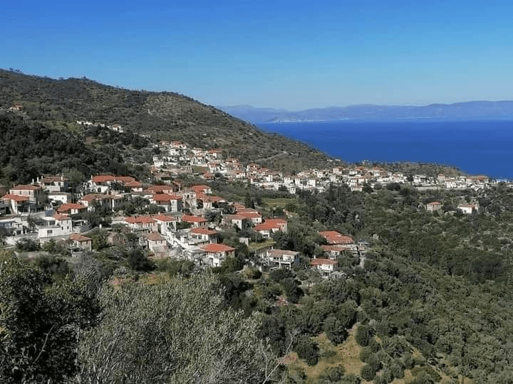
Recently, on August 13, 2021, the cultural center of Agiannis was inaugurated, which includes a folklore museum, a shadow theater exhibition and a lending library.
A wonderful job, as the president of the landscaping association of Agiannis Stratis Dalianis said, is the work of a group of people who helped to make it happen. The members of the landscaping association of Agios Ioannis and the friends of Agiannis, out of love and excessive interest for our village and our place, did what they could with their time and offerings, without powers, static studies and seals. Let them be followed by our competent and other fellow citizens, so that they become more self-evident for our place, such as the final and irreversible opening of the “Holy Space” of the 2nd National Assembly of the Greeks and its promotion on the website of our municipality, and finally, after so many static studies, the opening of the Archaeological Museum of Astros.
The folklore museum is housed in the primary school of Agiannis that was built in the 1960s, at the entrance of the village in Koutri, in the place that was the famous marble School of Karytsioti. Our great benefactor Dimitrios Karytsiotis <1741-1819>, was born in Agios Ioannis <Agiannis> and according to the Agianniti tradition, he left “with one tsarouchi”. Our great benefactor, a powerful Agiannitis patriot of the Diaspora, found a way to allow the 400 years of conquering Turks, before the Greek revolution of 1821, the acquisition and operation of the Karytsiotis school in Agiannis in 1798 and in the Karytsiotis school branch , which opened in 1805.
The museum will be open every day from 6pm to 8pm, otherwise if anyone wants to learn more or visit it can call 6973738850, Mr. Stratis Dalianis.
Also on the 13th of August 2021, in the place Koutri in Agiannis, an event was held by the landscaping association of the village with the theme of Dimitrios Karytsiotis Great Benefactor, School of Karytsioti, Unveiling of his bust.
Our compatriot Nikolaos Barlas, son of Michael from the Diaspora and distant Toronto, Canada, responded to the first call of the president of the landscaping association and financed the bust of Dimitrios Karytsiotis, expressing his love for the place where he lived. Nikos Barlas, a successful businessman in the foreign land he lives in, has from time to time helped other clubs and for that we are grateful and we wish him to be always well and to always have his mind in our village. The club decided to honor Nikos Barlas by appointing him an official member and awards a plaque and a commemorative diploma of honor. At this point, the niece of Nikos Barlas received the commemorative plaque and the diploma of honor and with the request to convey to her uncle the love and gratitude of the people of Agianni to him. Then the unveiling of the bust of Dimitrios Karytsiotis took place.
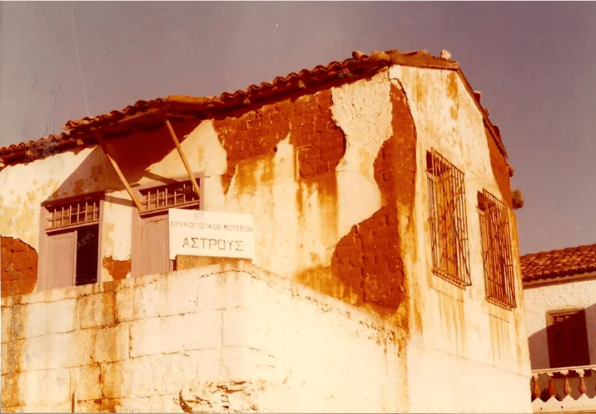
It is relevant to our topic how the Astros Museum started and operated in the 1950s and 1960s, our late fellow citizen “ancient Greek” our respected professor Kyriakos (Koulis) Hasapogiannis. The idea of the Astros Museum was started and became a reality by our late respected professor (it was not “transformed” by anyone, it was “made” by our late respected professor). In the 1950s and 1960s Astros had a museum and today the Archaeological Museum of Astros remains closed after the pretext of the crack and with the trap of studying the pretext of static adequacy. At the same time, our municipality “forgot” the creation and catalytic offer for the Astros museum of our respected professor Kyriakos (Kouli) Hasapogiannis and distinguishes unjustifiably and narrow-mindedly on the website of our municipality by chance employees of the Ministry of Culture in 1985, let there be a museum 1950.
Our fellow citizens, members of the landscaping association of Agiannis, friends of Agiannis and the Agiannites of the diaspora practically take in their hands what belongs to them, do not wait for the Ministry of Culture and the authorities to “study” them, approve and seal them. As they did recently in Agiannis and as our professor did in the 1960s, they will soon open the “Holy Space” of the Second National Assembly of the Greeks and the Archaeological Museum of Astros, there are no more unjustified excuses and pretexts.
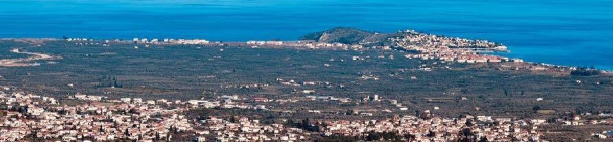
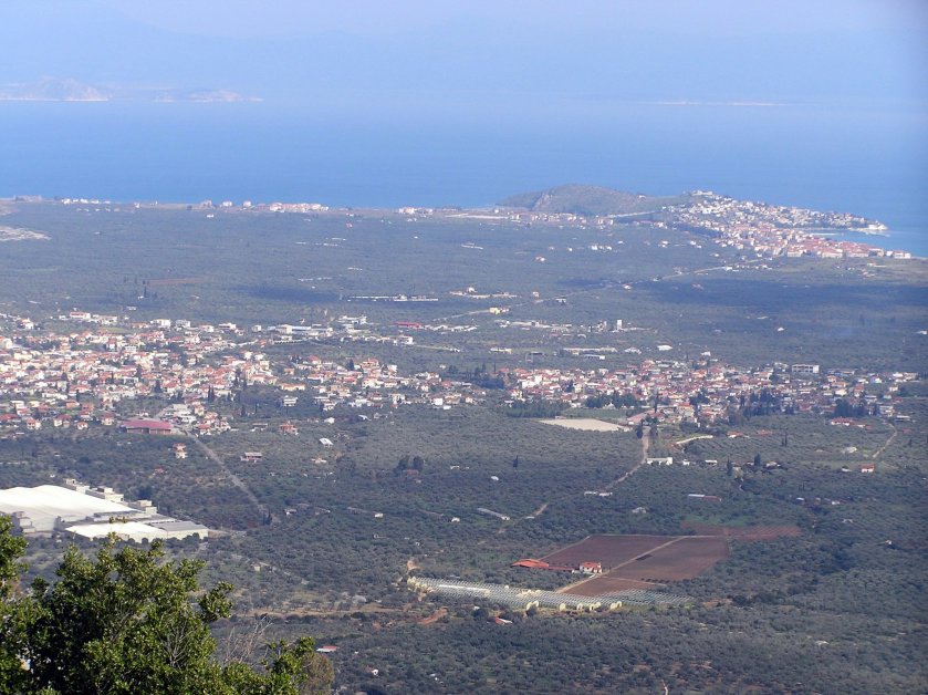
Agiannis was the capital of Greece of the Provisional Government of the Revolution, from August 15 to October 1 and the neighborhood of Soulinari was the metropolis of Agiannis. “The church of Agios Vassilios was a large church which was located at the bottom of the village and specifically at the place of Matthew and near the source of Soulinari. The church, which was the metropolis of the church, was completely destroyed in 1826 and in its place today a simple shrine has been erected. many mansions of important Agiannites (such as Perros, Sarigiannis, Matthew etc. (of the Zafeiropoula brothers)) and various churches (Agios Efstratios and Agios Petros) ”, by our fellow citizen Giannis D. Kourbelis
In the summers when the village was “full”, many residents came for holidays, in Soulinari we had a festival every day. It was very crowded with about 20-30 people, who waited 2-3 hours sometimes for their turn to get water with the linens, the tessas and the barrels loaded on the donkeys. It was a pleasant social event and the gossip from the women “go cloud”, who looked at who and the like. Many went more for the gossip and supposedly for water with a small pitcher. Sometimes my grandfather would send me to the tap for “some cool water” and I would go with a very small pitcher, a clever trick, and the women who were waiting to fill their barrels would leave me first, since “I had a small pitcher”…, but most likely and for not listening to gossip.
The young men and women of the village also went to Soulinari for strange hours for a bridal market, to go elsewhere .., they went for water and they were very thirsty and when they were lucky and there were no people, they felt the first heartbeats. The young people then always made the first move, indicatively with the following ..
From Smaragdi Arvaniti.
“In Agiannis there is water, they call it Soulinari,
and whoever suffers from love to go and drink, to become!
My little Agiannitopoulos, you have burned my heart “.
And so that there is no doubt they continued their siege
The little water that ran at night, when the residents did not get it, we share with the barber Theodore Maglis, for watering our orchards and trees in front of the house. There was a small concrete ditch and our own small cistern made by my “versatile” grandfather. In the orchard we had tomatoes, zucchini, beans, cucumbers, aubergines, okra, maize, we even watered the large arbor about 30-40? meters that made beautiful grapes, heptakilia, aetonychia and the red agiodimitri, and our figs, how not to love Soulinari…
We are lucky that our house was close to Soulinari. At night, my mother, who was not very crowded, would carry water with the tassels and the tins for washing clothes and would fill the two cauldrons that were in our yard under the mulberries, when when I helped too. Once our teacher Tassos Kalfagiannis inspected us at the school for cleanliness, I would have been 7-8 years old then. Most of us went to school barefoot. When he reached me he told me to go home to wash my feet. I run to our house and dip my feet in the cauldrons that had water for washing. and on the way to school, my mother shouted from behind “Turkish boy” you ruined my water. I go to school my feet as they were wet were filled with dust, street gallows and when the teacher saw me like that he laughed non-stop, well done you washed them nicely, but next time your mother washes them
Just above Soulinari was the house of Tsaroucha who came in the summers, he was very old in the 80’s, and he played music non-stop even at noon with a musical instrument that he played on foot, a lantern? I did not know his name. On the roof of this house once around Easter, the tsarouchas had not come yet, all the children of the neighborhood <girls and boys> had a party and danced, I was very young, suddenly the dancers inadvertently pushed me under the roof in Soulinari, but hard nut I did not suffer anything, I was accustomed to the hardships. , it seems that Santa Claus saved me that time .. Once again I had straightened Sourlis’ elbow in the well with my head, I still have the marks, when the oss of our donkey was cut or my echo
Someone called me and knocked me down. the cork, or both together, I do not remember what we called them.
Since we are talking about caravan and cork, the best was when I was carrying the bundles from our fields to the “kakoleo” with our mules. russia and cobra. My father would load them for me and wait for me in our fields, and I would manage to get rid of them and put them hard on our lawn. On the way back I was enjoying the carriage, as if once the cobra loaded with limbs in the xerokambi turned me over and I cut the ingla with rags and I came back empty-handed and scared, but my father welcomed me with a smile, as I always did.
We had our policies even then. Once my mother, above our oven in the fig tree, was caught by the hair with her neighbor with a lot of French… because the neighbor wanted us to let old Kapyla, my grandfather’s brother, vote for her party. When I was very young I was sitting with the old man Kapyla, barba Costa Kourogiorga, on our porch, he could not move because he was crippled, he had fallen from his arbor on the terrace with the stones behind our house, and we were enjoying the spectacle, it was nothing Dozens of women and men who were trying to separate them, but were holding their hair tightly .. Natos and the barba Giannis Stathogiannis, almost squealing, were very old, over our cistern on the side of the road to Soulinari he was coming with his big mustache and his white hair with a curl up and he was shouting loudly \
Fortunately, at that time, Pagios came again, he was coming from Soulinari, he would be in Xerokambi, riding a horse with also a big mustache and white hair, with the tsemberi tied like a fez and his dark fustanelles and behind him with many mules loaded on foot about a dozen servants of Agiopetrites. Do you want out of respect for Pagios to pass or did they get bored of the debauchery, the battle stopped, and those involved withdrew, continuing their French, and Barba Kapylas made his cross ..\
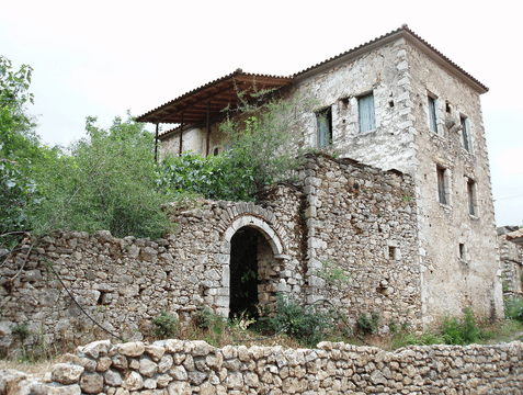
The former house of Panagiotis Giannoukos (Pagiou), benefactor of the community of Astros. This mansion belonged to Agiannitis, a friendly and friendly Panos Sarigiannis. Panos Sarigiannis was one of the most important personalities that Agios Ioannis has highlighted. He was the son-in-law of the also prominent Anagnostis Papazoglou, the protagonist of the struggle, with active participation in the It is located at the bottom of the village, between the Old School and the Soulinari spring. A few meters lower were the ruins of St. Basil, once the metropolis of St. John, which was completely destroyed by Ibrahim in 1826. This building has a large size and impressive dome. Next to this house there are the mansions of Perros and Matthew “, by our fellow citizen Giannis D. Kourbelis
“The mansion of the Kourogiorgas – Fourliga family in Agios Ioannis. It is located in the place “Elagos – Agios Vassilios”, near the source Soulinari. A lower school of the village was housed here during the Turkish occupation “
When Ibrahim in the revolution in 1826 burned down our homeland and the school of Karytsiotis in Koutri in Agiannis, also then there was no state and our politicians were forced to run to the mountains to be saved. Our ancestors, the people of toil and everyday life, did not bend or surrender. They did what they could in the ashes to say in their own way the state is here, as they still offered their homes to be used for schools, after the school in its place had burned down.
Our house was relatively large, had a large loggia in front and a wooden balcony downstairs where our threshing floor was located on the border with the area of Santa Claus. It had a large linen of about 25 sq.m. My grandfather Michalis Stravosogias was always in front of such people, he was always in front of them for such things, singing them with his stories. Knowing the place, I guess linen was the school room in 18 they were finished with the sea bream we were looking forward to playing with the sea bream, we are leaning and belly up to the threshing floor. It also had the basement, about 20 sq.m. under the winter house, which was something like a hiding place since there was a waterfall with a vertical staircase from the winter house, and the stones from the wall that were built quickly in an emergency or in possession of the small inner door so that nothing but a wall could be seen, is still inside our homes. You should have known to find the one covered under the chest and a rag and shaker to enter the basement. In the 1950s we had two large wine barrels in the basement, for about twelve barrels of wine, two meters long and almost two meters high, which I stepped in to clean in the fall. one still exists today. In the neighboring house of Kapylas, old of Matthew, there was a similar hiding place that some said reached the hiding place of the forerunner ???. Before the harvesters came, our threshing floor was used by many neighbors for threshing, I remember 20? piles around. The good thing was for fun we slept on the lawns and at night we listened to the stories about ghosts and fairies from the older neighbors. We were fed up with threshing when we were threshing, with mules and horses crawling around, and many times we crawled behind the haystack in the straw, but you had to be very fast if you fell because the mules would step on you, that’s why my uncle Costas Kourogiorgas the joke, leather strap. saying “sputum” you will leave as if the mules are pressing. In front of our house was Soulinari, below the border with the threshing floor is the area of Agios Vassilis, behind the mansions of Matthew, Barleika, Pagios, Perros, then two houses, after the old primary school and more beyond the neighborhood of Prodromos, other houses and Prodromos. This was the Soulinari neighborhood.
The mansion of Matthew with its peculiar big chimney, which had the underground large crypt, today owned by Kapyla (descendants of Kostas Kourogiorgas).
In the 1950s it was beautiful in the village. There was excellent social contact and mutual respect with everyone and everything, at festivals, in churches, in daily life in the precincts of the precursor and in Soulinari, in joys and sorrows. We respect the elders, they were all barbarians and aunts (uncles) and aunts).
During the holidays we wore our “goodies”, we went to the church and to the dances, which everyone danced in the square, if we had any drachma we drank an orange juice. We are happy and happy for what we had and we did not know better, nor did we want to know. We had it all and it was enough, they just did not have money but we do not need it… ..
Personally, I did not feel comfortable during the festivities and the big riots with my ornaments and my “good”. I felt better and I preferred to go to the “tsoulaftra” for watering and to play with the neighbors with the tsipoura, the letharia and the soil in Soulinari.
5-6 years ago we published the following, today it seems something is finally happening or will happen soon, after all the obstacles collapsed. With a few small changes we publish them again, because we believe they are still relevant today.
We recently read about the small problems with the road signs, which we are still waiting to be corrected, better late than never, because they are very important for our visitors, certainly not so important for the competent and locals who know where to go without looking at them. our road signs, and we ask everyone who knows about these mistakes to report them to the competent service of the municipality, someone has to do it, no autopilot will do it, maybe the municipality does not know them or forgot them to correct them We want to believe that one day the municipality will understand these small mistakes are very important and we will not forget them ……….
We remembered that it was Astros in the sixties that everything changed drastically and so hastily, as if everything happened in the sixties.
In the sixties many great changes took place in our daily lives locally, nationally and globally. This “generation of sixty” decided to change everything everywhere. Let us mention some such as May 68, Che, the peace movements, the emancipation of women, the hippies who used to tell us every day “Make Love, not War”, “socialism with a human face” by Dubeskek and the insight of Willy Brandt At the national level, the dictatorship of 1967 stopped the social and political changes and temporarily put this “generation of sixty” in plaster, killed its Levantine soul and restored the morale of the cops and collaborators with the known results. We will leave the global and national for others and for the past. Let us come to Astraina of the sixties.
Here the idea of the Astros Museum was built by the “ancient Greek” Koulis Hasapogiannis, (these we had, we could always do with “measure”, these we did)
The Astros Museum
Astros before 1960 had a museum and promoted as much as possible our cultural heritage. In the photo above is “the first Astros museum as it was before the demolition. Here the “ancient Greek” Koulis Hasapogiannis built the idea of the Astros Museum, carried the marble statues with his fellow villagers and sometimes asked for the help of Panos Kampilis, who was younger and stronger, to raise them on the staircase. His age also caught him ostensibly from one end to help. The railings on the windows for safety by the archaeologists were not put by Karytsiotis or the agronomist and gardeners of the garden, they were put by his hands μας our late professor and inspected them every time he opened the Astros Museum.
The Karytsioti School became the Astros Museum and served the place beautifully for several years, (we had these, we could always do this with “measure”, we did these), until it became the “pretext of the crack” and closed indefinitely.
I’m sure if he lived today, he would gather us all in the square, give us a nice festive speech and put us all in front with trowels and cement to close the “pretext of the crack” today …… Everyone, the mayor in front, would have him convince him certainly would not disappoint him. He would sit next to you and do whatever he could to help or stir the mud, but more to make sure we did a good job and finished it, today.
The “ancient Greek” Koulis Hasapogiannis, was accidentally born 2,500 years later. His whole social and professional life was full of “mutual respect”, “Greek measure”, unparalleled “ethos”, and “excessive courtesy” for the smallest detail, even when some of his students teased him, he smiled sweetly and politely and he quickly turned to his own subject so that the students could learn something, even though they wanted a break…. , these were our teachers. ”
Today we do not have a museum and today we do not want to promote our cultural heritage, because we let some “stupid employees”, as one of our great poets used to say, insist on having closed and inaccessible today, not only the Museum, but still without any excuse the pretext and the “Sacred Space” of the Second National Assembly of the Greeks.
Today the head of EFARK, Ephorate of Antiquities of Arcadia, decided without any excuse and does not want anyone to see the walls and an inscription of the archeological service of the “Sacred Space” of the Second National Assembly of the Greeks, nothing else exists in this area, and this in her opinion highlights our cultural heritage. We do not understand this persistence, crookedness and narrow-mindedness.
We know that we “must build Romeiko in the space and sector in which we are” and we must all take public positions on all issues. We wonder why until today the local “leadership”, our elected representatives, the mayor, the regional governor and our deputies do not make a public intervention to the competent “stupid officials” and on the issue of the “Sacred Space” of the Second National Assembly of the Greeks. At least let us tell them their position publicly. We will soon find them in front of our elected representatives.
In the final analysis, not all these “competent” people do nothing, but it is our fault that we allow them and as we understand, they will soon take their place.
We do not understand why “the stones do not rise” to open the “Holy Space” permanently and irrevocably.
The water
The whole village before the sixties had 3-4 fountains. We went with the barrels and the sinks very far for water. Around sixty they brought fountains all over the village in every neighborhood and slowly added water to the houses later. With the water, the village slowly changed, the inhabitants planted the first oranges and cultivated their pergolas.
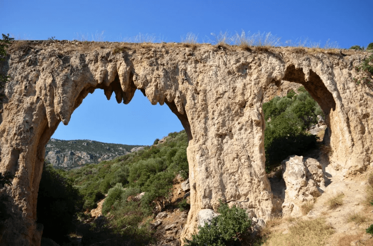
The “farm”, the large space that starts from where OTE is located, and this space belonged to the farm, to the cemetery and from “west to east”, with all the schools, stadiums and squares, its space Zafeiris Foundation, were donated by the biggest benefactor of our place D. Karytsiotis to the School to pay for tuition the teachers of the school with the fruits and the fruits of the “farm” such as grapes, medlars. The water was also brought by Karytsiotis from the “manna of water”, above Loukou, with a stone spit, (aqueduct) that still exists, so that the village has water and the farm garden is watered so that the School is open . ”
At this point of the aqueduct it had been spread by the older and the younger ότι. That Karytsiotis had given instructions to the Arab keeper and gardener of the garden “to cut the water” from the village, when he learned the Astros museum was closed. Of course he would pass the farm back because there was no reason for the residents to have it anymore. Two hundred years ago the great benefactor brought us water for the village, gave us the farm and built the school. Today, two hundred years later, we are not even worthy to open the “sacred space”, let alone the museum, which we left to be demolished ten years ago….
Electricity
Electricity also came around sixty. I still remember reading with the oil lamps and the lamps.
The streets, The society and the politics of the time
After the water and the electricity, it was time to open the roads, another great work of the time. Before the sixties in Astros there were three taxis and 2-3 trucks, people were moving by buses, in Agiannis There were two buses upstairs and two downstairs. Children in Agiannis we went on foot. Let us remember how the roads were made.
Let us say a few words about the society and politics of the time to better understand what we are saying. After the occupation, the civil war and the guerrillas, the people of toil closed themselves to survive one more day. The left was now defeated and chased in relentless persecution. The democratic faction was frightened and also persecuted by the dictatorship of Metaxas and the civil war, it was questioned and despised by the establishment. The right was in its greatness.
The deputies of Arkadia in 1958 were the 6 of the right-wing EPE, Triantaphyllakos, Papailiou, Aposkitis, Michas, Pavlopoulos, Kalteziotis, Papadimitriou, and N. Bakopoulos of the Democratic Party, Liberal Party and in 1961 the E, T Aposkitis, Michas, Pavlopoulos, one of the right-wing Markezini Tsakalos KP and one the democratic N. Bakopoulos EK. The numbers tell the truth convincingly, no analysis is needed. At that time, the leftists in Astros were counted on the fingers of “one hand”, leftists, there were no communists then, because the word was “myasma”, no one said that word. The Democrats were a little more numerous, but most of them for the sake of survival hid and read the Democratic newspapers secretly or folded them in when they bought them so that they would not be seen. Astros was more right-wing than Arcadia and almost everyone in Astros voted for Dimitraki and Apostoli, say about 80% and almost all the other right-wing party leaders…. At that time, the village was ruled by Dimitrakis Efthymiou and Apostolis Hasapogiannis. They were the two “big party leaders” of the village, there were other small party leaders, who as more affluent had many political friends, some of whom worked part-time in their jobs and out of obligation always voted for their friends, the powerful political deputies for many years. .Triantaphyllako and E. Papailiou, father of the current MP Arkadia of SYRIZA, here we are not talking about nepotism and family rule, but the people say in similar cases “the kingdom goes to work” …… Although Dimitrakis and Apostolis belonged to the same party of the right (EPE) were fierce enemies for their own reasons, perhaps for the plots they shared. They and their friends, or as their leaders or minions called them, hardly talked to each other, they were political opponents.
Then a miracle of unity and understanding took place. Dimitrakis and Apostolis agreed to make Saranto Kanellopoulos, a left-wing communist, not an “initiated” communist, president of the community, to do any work. Sarantos was “a leftist ideologue, but respected by the inhabitants..His first job was to open the streets. He would go in front of the bulldozer with the cigarette in his mouth and a chisel and say to the bulldozer “varto, varto” .. to throw the olives. , and kept Sarando for good and for bad for his boss Dimitrakis. In fact, a cousin of my uncle, let’s not say names, took him to court because he opened the way for him to pass and the judge assumed and asked the cousin “there is his house across the street, he also cut from his own field” the cousin as she was honest without thinking he confessed “he cut more of his own” which was the truth, and so the judge easily concluded “the accused is innocent”, with the cousin looking curious .. My father came from Agiannis and saw the hatred Our pergola was missing the fence spikes, the zucchini and the “batakes” were on the way down the road. My Uncle had overdone it. He disliked the trout and the zucchini, but he liked the road, as a progressive man he was he laughed with joy, he could not go and his brother to the courts. Besides, my grandfather built the house at this point in 1915 and had entered a lot since then, on the contrary, many did and let them have space, once the road in front of our house used to pass by with difficulty only a donkey loaded…. So somehow fortunately the roads we have today opened ..
Paralio Astros in the 1950’s
The Karella factory
I happened to be present when the late Tzimis Gardikiotis and Alkis Hasapogiannis both started with a lot of passion and love for the place the first conversations in the late sixties to build a factory in Astros “for the good of the village” the factory became later and changed the village.
University fees have been abolished
We mention this here, let it not be a local issue, because it had very great, I would say indescribable effects on the Greek and local society.
In November 1963, the Democratic Party and the old man of democracy won the national elections and the old man of democracy, under the influence of E. Papanoutsos, abolished the tuition fees for the universities. Then, in order to go to university for a year, your father had to sell a field if he had one. As a result, all the toiling people could now more easily educate their children to change their lives. When I finished high school we are 40 students and I think 36-38 went to universities, in Law we are 6.
The names of the streets
I do not know what happened to the street names, I did not follow that, and I’m sure, mistakes would be made that we can correct later, we all have to have suggestions. I will be allowed to suggest some street names that I consider important, if they have not been made and do not exist, I hope that those in charge will take them into account in the future.
We must have a road in Astros called.
Giannis Mattheou, Kyriakou Hasapogianni, Sarantou Kanellopoulos, Tzimis Gardikiotis. (the street that is our home), Alki Hasapogianni
These names are with us, they are full of Astros, let’s say otherwise there can be no Astros without… .Kyriakos Hasapogiannis… ..My uncle vice-president, I will not mention him for anti-nepotist reasons, let his cousin’s descendants mention him ……….
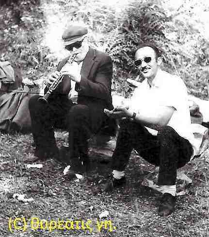
Barba Panos Barlas or Katsianos was a real helper, without knowing who Epikouros was, who played the clarinet in Agianni in the fifties to entertain himself more and less his fellow villagers. His house was next to the traditional guesthouse “Fountas”
Barba Panos decided with his savings from the clarinet to acquire a ribbon, a small carpentry craft for the younger ones, next to his house which was a rock, so that he could easily supervise.
The work on the ribbon was done by his two older children, the work was good and they needed more space to expand their industry. Barba Panos supervised everything and caught a board in grace and appearance.
Then he decided to build a carriage, which was a larger cart, with two large wheels, to throw away the soil and rock that his children dug almost every day for about 20 years to grow the area of the ribbon, where today is traditional hostel “tassel”.
Loufolias did a lot of work, for a glass of wine or 2-3 cigarettes, from time to time and for a plate of cuts. Loufolias, when he did not carry the trumpets from Karamatzanis alone today on the ribbon, very large wood for planks, carried by 2-3 people normally if Loufolias did not want, most of the time he worked the cart and threw the soil and the rocks outside the village, on the side of the road in Perdikoneri.
But Barba Panos was forward-thinking and had reserves.
Plastira was putting Giannis Koutivas to pick up other children and throwing some carts, because Loufolias would be drunk somewhere.
The plan was for everyone to push or pull the loaded body up to the peridoneri, you could see maggofa uphill, and on the way back everyone went up to the body and Plastiras confidently and confidently led the body downhill back to the ribbon quickly to catch up and we go many times… ..
One fine summer day, when I beat all the players of Plastira behind the school of Agiannis, we had to go late to the ribbon of Barba Panos, it was arranged.
We went out to the pond and gathered about a dozen children to help us take the carriage to the perdikoneri and the maggoufa uphill, mostly younger ones I do not remember now. Was it written that day to stop temporarily or for a few years…? Barba Panos’s plan to grow the ribbon, I think the program stopped that day.
Plastiras was driving the carriage full of children too fast, from his coffin that he lost the players earlier, a very big case, or because we were late, his carriage left at the turn that was the hut of Loufolias and the side over the Canelias’s house, fortunately no one died or was seriously injured and the wheels got lost in the paddocks in the mills under the forecourt, they are still rolling… and Barba Panos’ body became a mess.
Little by little, all of us limping and groaning, we kicked her under the lacquer, so that Barba Panos would not take us for granted, and we left him waiting for the carriage, which you could see, and other soils that he left necessarily and definitively for Founta.
Let us mention here something about the organ players and a nice story.
The ones I remember are Barba Panos Kon. Barlas or Katsianos ►8 on the clarinet that he always played with fun, in times of need his brother Barba Mitsios- Mitsiaronis also helped. Tassis Dikaios – Drapetis – on the lute, Marinos Aloupogiannis on the violin, Sakkas (Tassis Kon Barlas) on the pipe and Lampis Kampilis on the drum.
From the surrounding villages the most famous were Angelletos or Bahatis from Meligou on clarinet, barba Giannis Mourloukos or Seliverdes from Verneva on lute and Perrai from Platanos on violin.
But let’s say something about Barba Panos Katsianos. He was a very gentle and happy man with what he had. He told us that he had never been ill, had never had a headache and had never taken medication or aspirin. In the summer evenings we took him for chants to Agiannis guys then. He was very happy to play the clarinet with us for many hours.
Stratis Dalianis or Lokanikas, an old mayor, was collecting money from everyone to pay Barba Panos. I remember once he had a penny (50 drachmas) and he put it in a pocket of Barba Panos. After a while he would take it and put it in the other pocket and he did it all night to make Barba Pano believe that he was putting a lot of money into it.
Of course, Barba Panos understood that, but he continued the clarinet with joy the next day when he finally found it. the fifty asked us on the ribbon we were going when we were going to sing. He wanted to play the clarinet and enjoy watching everyone have fun.
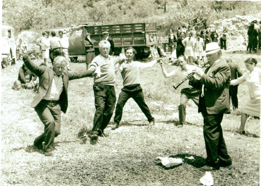
At that time, at the festivals, everyone danced together in Agiorgis Square, let’s say without exaggeration, and 100 people danced together. Anyone who had money and was anxious – got into fun and threw something for the instruments.
Later, Bahatis from Meligou, after each dance after each song, played the clarinet for a long time to give him money to play and dance. This tuning had been exaggerated, which people no longer wanted, but it gradually became a habit for everyone.
Once it was Easter days and people were dancing in Agiorgi next to the mulberries and then the other organ players started playing for money and since no one was throwing anything because they could not, with the loud crowd, who usually spoke very slowly, hear it everyone, Barba Panos Katsianos, said: “You guys are dancing, let the world dance in the air, we are selling them !!!” and he started playing alone and then the others followed him what to do. ”
Since we mentioned our friend Plastiras, who greeted us for the other world, I remembered another short story. Plastiras, Stelios Katsianos, who also greeted us for the other world, Giannis my cousin Lefikis, and I Giannis the Lord, we had good company, we smoked in the house of Korobokos which was closed under Katsianos…. and at noon we went for nuts and cucumbers to the pergolas in the mills, everyone slept at noon and whoever gets the grace…. the guard Tsioros and Matzouranis did not catch us with anything., that we did not eat we played in the mantra of Prodromos until the final victory and at the end everything was taken by a lucky person of the day. My cousin John left for Canada when he was young and when he returned after many years he found his company. old friend and after they kissed warmly he said.
Look at “the chief thief <he meant the nuts ,,,> they called him chief warden” and they started laughing non-stop that they remembered our glorious days ..
Mystras, also known as Myzithras in the Chronicle of Morea, was a fortified Greek city and former municipality (Municipality of Mystras) in Laconia in the Peloponnese Region [1]. Located in Taygetos, near ancient Sparta, Mystras was the capital of the Byzantine Despotate of Mystras in the 14th and 15th centuries, experiencing a period of prosperity and cultural flourishing.
The Despotate and the Ottoman conquest
In 1348 the Despotate of Morea was created, with the first despot Manuel Kantakouzinos (1349-1380), son of the emperor John VI Kantakouzinos. He was succeeded by his brother Matthew Kantakouzinos (1380-1383) and his son Matthew Dimitrios I Kantakouzinos (1383-1384). The latter was confronted by the emperor John V Palaiologos, when he claimed greater independence from Constantinople, and gave his place to the emperor’s son, Theodore I Palaiologos (1383-1407). In the years that followed, the despotate expanded throughout the Peloponnese, upgrading the political, administrative and spiritual importance of Mystras.
In 1429 a second despotate was created in Moria, based in Glarentza, whose leader was Constantine IAI Palaiologos, while in 1430 a third was founded, based in Kalavrita, with Thomas Paleologos, brother of Constantine and Theodore II, as despot. Paleologos, who was despot of Mystras in the period 1407-1443. In 1443 Constantine became despot of Mystras, a position he held until 1448, when he was anointed emperor – the last – of the Byzantine Empire. The last despot of Mystras was Demetrios Paleologos (1449-1460).
On May 30, 1460, Demetrios Paleologos surrendered Mystras to the Ottomans without a fight and clung to the sultan’s court.
The churches of Mystras
Mystras is dominated by 7 important churches:
• Agios Dimitrios (Diocese). Royal wooden roof, with beautiful sculptures on the iconostasis and frescoes. In its courtyard is the Metropolitan Palace, today the Museum of Mystras.
• The Evangelistria, single-storey with a characteristic wide narthex.
• Agioi Theodoroi, with the characteristic famous octagonal dome, the largest and most ancient church of Mystras. It preserves impressive frescoes, including a portrait of the emperor Manuel II Palaiologos dated 1423. Here is the tomb of the despot of Morea Theodoros AD.
• The Virgin Hodegetria (Boss). This is the name of the three-storey two-storey domed church with two chapels on either side, that of the “gold bullions” because it is internally covered with a hagiographic composition of angels holding gold bullions of the years 1314, 1319, 1320 and 1322, and the other of Andronikos depicting the emperor Paul despot of Mystras Theodoros I Palaiologos.
Hagia Sophia, above the palaces, of 1350, was the catholic of the monastery of the Life-Giver Christ and probably constituted the church of the Palaces. Many members of the ruling class of Mystras have been buried in it and in the tomb of the northern portico was found the silk female dress of a noblewoman of the beginning of the 15th century, which is in the museum of Mystras.
• The Predictable.
• Pantanassa (nunnery), whose church is the best preserved monument. There are also the tombs of Miss Cleopa Malatesta and Theodora, the wife of the emperor Constantine IAI Palaiologos.
These churches were catholic monasteries. In general, the churches of Mystras were a place of learning of Byzantine architecture, painting, hagiography and spatial study of the time shortly before the Renaissance. Today, only Pantanassa functions as a monastery. Many of the churches owe their present form to maintenance work carried out by Anastasios Orlandos shortly before 1940. The form of the churches is connected with the natural relief of the place where they were built. Thus, all the churches deviate to the east, in violation of the relevant rules of religious tradition. One of them, Agios Georgios, faces north to south. In terms of architectural form, the simple royal type and the typical for Mystras type dominate, combining the basilica on the ground floor and the church with domes in the gallery. The external galleries are also a trademark of the churches. Overall, the architectural form and building materials form a perfectly harmonious whole with the environment.
In the ancient Greek world Delphi was considered the centre of the universe
From the Time Machine
At the foot of Mount Parnassos is built the oracle of Delphi, the navel of the earth according to the ancient Greeks. According to legend, at this point the eagles sent by Zeus from the East and the West met in search of the center of the earth.
The original photo of Loukas Hapsis depicts our Galaxy from the Navel of the Earth ….
Here was the navel of the earth where the eagles of Zeus met and Apollo killed the dragon Python. What should the faithful do to get an oracle for the future (drone video) – TIME MACHINE (mixanitouxronou.gr)
From Wikipedia, the free encyclopedia
Delphi was an ancient Greek city in which the most important oracle of the ancient Greek world operated. The city is mentioned from Homeric times with the name Pythos. At the beginning of historical times it was one of the cities of ancient Fokida, but gradually the role of the city was strengthened and developed into a pan-Hellenic center and a sacred city of the ancient Greeks. It was also the center of Delphic Amphitryon. Delphi maintained its important position until the end of the 4th century AD, when the operation of the oracle was finally put to an end by decree of Emperor Theodosius.
Apollo was officially crowned ruler and protector of Delphi, and at the point where Python was slaughtered, the supreme god Zeus threw the sacred rock, a huge white stone in the shape of an egg, and so Delphi became known at the end of that time. of the world as the “navel of the Earth”.
Delphi is known as the navel of the earth. According to legend, when Zeus released two eagles, one from the East and the other from the West, they met in this place that was considered the center of the world.
Before the recent health crisis in 2019, thirty-four million visitors came to our country and the number is increasing every year. We had a 62% increase in ten years (in 2010 it was 21 million, in 2006 it was 14 million). Most of us visit for our rich history and basically to enjoy the “sun and the sea in the Aegean islands” and to see our most important archeological sites.
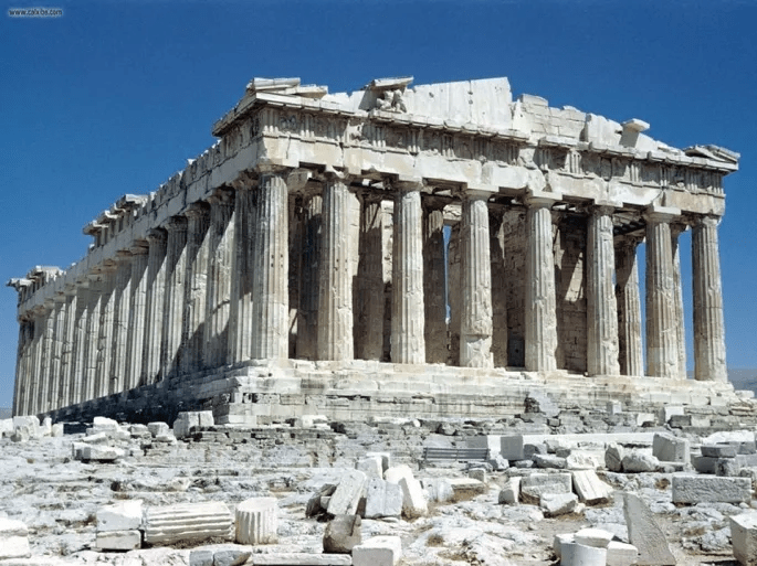
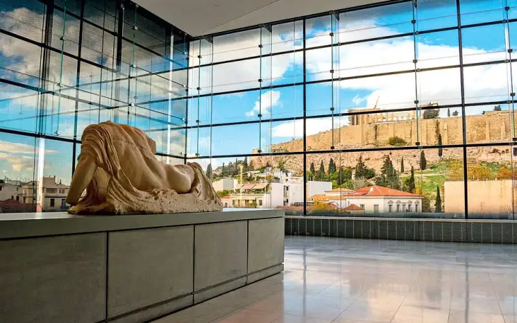
It is no exaggeration to say that most people come to see the Parthenon, which undoubtedly symbolizes the Greek Miracle, the Greek measure, human mutual respect and is admired as a symbol of universal and enduring values of excellence, democracy, art and global human evolution.
As soon as we go up the propylaea and see the Parthenon, it causes admiration in general for the human race and our ancestors. We stop speechless, admire him and enjoy him with awe and emotion.
We want to confess that in every visit to our homeland, we always find time to visit every year the Parthenon and the prison of Kolokotronis in Palamidi. They are our great miracles of the Greeks, which we like to visit many times, we are not satisfied with them, they inspire and guide us.
The Parthenon is undoubtedly the greatness of the world, full stop.
The stolen Parthenon Sculptures.
The Parthenon Sculptures (also known as Elgin Marbles by the English because of Elgin), are a collection of sculptures from the Acropolis of Athens. They were removed and stolen by Thomas Bruce, the 7th Earl of Elgin, ambassador to the Ottoman Empire from 1799 to 1803, and transported to Britain in 1806.
England never had legal possession of the Parthenon Sculptures. The possession of the Sculptures is a robbery and the international community and the EU must isolate and condemn England financially until they return the Parthenon Sculptures to the Acropolis Museum.
Melina Mercouri passionately claimed the return of the Parthenon Sculptures and blasted everyone who referred to them as “Elginia”. Melina Mercouri as Minister of Culture in 1982 was in Mexico at the Unesco General Conference. “Or you need to understand what the Parthenon Marbles mean to us. It is our pride. They are our sacrifices. It is the supreme symbol of kindness. It is a tribute to democratic philosophy. It is our ambition and our name. It is the essence of our Greekness… »
From Wikipedia, the free encyclopedia
The Parthenon is a temple built in honor of the goddess Athena, patron saint of the city of Athens. It was the result of the collaboration of important architects and sculptors in the middle of the 5th century BC. century. The era of its construction coincides with the ambitious expansion plans of Athens and the political prestige that followed vis-.-Vis its allies during the period of Athenian Hegemony in Ancient Greece. The architects of the Parthenon were Iktinos and Kallikrates.
The Parthenon is one of the most recognizable monuments in the world. According to the prevailing view, the modern interest in the monument appeared during the European Enlightenment of the 18th century, and is admired as a symbol of universal and lasting values of excellence, democracy, art, etc. In Greece it also has a special place in the national feeling, both the monument itself and the sculptures that have been removed from it and are exhibited in the British Museum. [26] According to the UNESCO World Heritage Center, the Parthenon as part of the wider monument complex has been on the World Heritage List since September 11, 1987. However, it is not the formal addition to a list that makes the Parthenon part of the cultural heritage. As a material project it is the most reliable testimony of a technologically and aesthetically advanced culture, which has significantly influenced the development of the modern Western world ………
The monument
The Parthenon is the most brilliant monument of the Athenian state and the colophon of the Doric style. Its construction began in 448/7 BC. and the inauguration took place in 438 BC. in Megala Panathinaia, while the sculptural decoration was completed in 433/2 BC. According to the sources, the architects who worked were Iktinos, Kallikratis and possibly Pheidias, who was also responsible for the sculptural decoration. It is one of the few all-marble Greek temples and the only Doric one with all its metopes in relief. Many parts of the sculptural decoration, the entablature and the ceiling panels were painted in red, blue and gold. Pentelic marble was used, except for the pillar, which was made of limestone. The wing had 8 columns in width and 17 in length. The placement of the columns is unusually dense with a ratio of column diameter to column height of 1: 2.25 (cf. the ratio 1: 2.32 in the temple of Zeus at Olympia and 1: 2.65 in the temple of Aphaia in Aegina). On the narrow sides there was a second row of 6 columns that created the illusion of a double temple. Another peculiarity was the existence of a frieze that surrounded the nave along its entire length and is perhaps the most obvious of the Ionic influences. The metopes on the east side depict the Battle of the Giants. The Amazon depicts the Battle of the West, the Centaur War in the south and scenes from the Trojan War in the north.
From Astros, Tripoli – Ancient Olympia 170 km, (2.20 hours)
From Wikipedia, the free encyclopedia
Olympia was the most glorious sanctuary of ancient Greece dedicated to Zeus. It was the venue of the Olympic Games which were held in the context of the Olympics.
Olympia was called Altis, meaning Holy Grove. It was built on the north bank of the river Alfeios. There are traces of human presence from the Neolithic period. Initially it was a rural settlement and gradually evolved into the largest religious center of the ancient world.
There was for about a thousand years the ivory statue of Zeus, work of Pheidias, which was known in antiquity as one of the seven wonders of the world. It was 12 m high and consisted of wood inside, but gold, ivory, silver, mountain crystal and semi-precious stones outside.
The starting point of the Olympic Games is placed in 776 BC. and was held every four years. But the Games are already much older, because according to their tradition, Pelopas started, who defeated the king of Pisa Oinomao in a chariot race. The various buildings, of religious and secular character, were gradually erected until the 2nd c. AD the form it has today. The oldest building is the temple of Hera and the newest is Nymphaeum. In Roman times, many buildings were completed and rebuilt as the Romans continued the games without interruption.
The operation of the sanctuary continued normally during the first Christian years during the reign of Constantine the Great. In 393 AD The last Olympic Games took place and a little later the Byzantine emperor Theodosius I, by his decree, banned their performance because they were considered pagan, while during Theodosius II, the final destruction of the sanctuary took place (426 AD). [2 ]
From Astros, Argos 34 km, Mycenae 43 km, Tyrinth 33 km, Epidavros 70 km
Ancient theatre of Epidavros
The theater of Epidavros is an admirable monument of acoustics that we can not acquire today with all the technologies .., they sound without exaggeration and the breaths, I do not exaggerate.
Once we visited the Epidavros Theater with our children, after a long trip from Canada and we went near a group of foreign visitors who had a guide. The tour guide went to the central point which was the place for the actors and said something like that.
Now I will clap to hear them sound clear throughout the theater ,, now I will drop a coin to clearly hear the banging noise all over the theater, everyone is impressed, we are sitting away in the seats… now I will take a deep breath to hear me throughout the theater…. the guide did not stop breathing and everyone started applauding, non-stop, these are our monuments that we have… ..Once the civilized people had theaters,….
From Wikipedia, the free encyclopedia
The ancient theater of Epidaurus is located at the southeastern end of the sanctuary which was dedicated to the healing god of antiquity, Asclepius, in the Asclepieion of Epidaurus. It is built on the western slope of Mount Kinorti. It is located near today’s Ligourio of Argolida and belongs to the Municipality of Epidaurus. It is considered the most perfect ancient Greek theater in terms of acoustics and aesthetics.
The ancient theater of Epidaurus was built by the architect Polykleitos the Younger as reported by Pausanias [4]. Pausanias [5] praises the theater for its symmetry and beauty. With a maximum capacity of 13,000 – 14,000 spectators, the theater hosted the musical, vocal and dramatic games that were included in the cult of Asclepius. It was also used as a means of treating patients, as there was a belief that watching dramatic performances had beneficial effects on patients’ mental and physical health.
It is considered the oldest city in Mainland Europe due to the existence of many archaeological monuments dating back to the Late Bronze Age, when it was one of the most important centers of Mycenaean Civilization and one of the oldest in Greece. The symbol of the city since ancient times is the wolf.
Mycenae (Mycenae, Mycenae) was an ancient city of Argolis near Mount Tritos and opposite the Argolic Gulf. The archeological site of Mycenae is located about 90 kilometers southwest of Athens, in the northeastern Peloponnese.
During the 2nd millennium BC, Mycenae was one of the largest centers of Greek culture, being a strong military fortress that dominated most of southern Greece. The period of Greek history between 1600 BC. until about 1100 BC. is called “Mycenaean”, referring to Mycenae. At the height of their glory, in 1350 BC, the castle and the lower town had 30,000 inhabitants and were 32 hectares in size. [1] Homer is the first to mention the city, describing it with the words “broad-shouldered, golden”.
Mycenaean Civilization refers to the culture of the Late Bronze Age, which developed in 1600-1100 BC. mainly in central, southern mainland and island Greece. [1] The adjective “Mycenaean” comes from the first archeological site where it was located, the Mycenae of Argolis, which are one of its most important centers. During its heyday it spread to Crete, the Aegean islands and the Eastern Mediterranean but also to Cyprus. Mycenaean Civilization is identified with the Late Helladic period. It is traditionally classified as prehistoric, as our knowledge of it to date is based mainly on archaeological finds. [2]
Mycenaean culture – Wikipedia (wikipedia.org)
Tyrinth
The low hill of Tirynths, at the 8th kilometer of the Argos-Nafplio road, was inhabited continuously from the Neolithic era until late antiquity. In prehistoric times the area flourished mainly during the early and late Bronze Age. In the second phase of the Early Helladic era (2700-2200 BC) there must have been an important center with dense habitation and a uniquely constructed circular building, 27 m in diameter, at the top of the hill.
• The castle of Larissa, built in prehistoric times, which was repaired and expanded several times since antiquity and played an important historical role during the Venetian occupation and the Greek Revolution of 1821. [46] It is located at the top of the eponymous hill, which is the highest point of the city (289 m.). The castle is first mentioned on the occasion of its occupation in 1203 by Leontas Sgouros. In ancient times there was a castle on the neighboring hill of Aspidos, which however is not preserved. Attached to walls, these two castles fortified the city and protected it from enemy invasions.
• The Ancient Theater, with a capacity of 20,000 spectators, built in the 3rd century BC. replacing the older neighboring theater of the 5th century BC, and connected to the Ancient Agora, it was visible throughout the ancient city and the Argolic Gulf. In 1829 it was used by Kapodistrias for the 4th National Assembly of the new Greek state. Today it houses cultural events during the summer months. [47]
• The Ancient The Agora, near the Ancient Theater, was formed in the 6th century BC. at a central point where roads from Corinth, Heraion and Tegea ended. Bouleuterion, built in 460 BC, have been excavated in the area. when Argos adopted the democratic state, Sanctuary of the Lyceum of Apollo and a palaestra, among others. [48]
• The “Criterion” -Nymphaeum of Argos, an ancient monument in the southwestern part of the city, at the foot of Larissa, which took its current form from the 6th to the 3rd century BC. It originally served as a court of ancient Argos, similar to the Supreme Court of Athens. There, according to mythology, Hypermnistra, one of the 50 daughters of Danaos, the first king of Argos, was tried. Later, during the reign of Hadrian, a fountain was created in the area for the collection and channeling of water from the Hadrian’s Aqueduct, which was located north of the city. The space is connected by a paved path with the ancient Theater. [49]
• The Spyridon Trikoupi House (built in 1900), where the politician was born and lived in his youth. In the following years it was used by the National Bank of Greece as a residence for the respective director of the local branch. In the building, which is not open to the public, there is also the chapel of Agios Charalambos where Trikoupis was baptized. [54]
• The chamber tombs of the hill of Aspidos.
• The pyramid of Elliniko near the village of Kefalari, southwest of Argos. It dates to the end of the 4th century BC. century and there are several theories about the use it may have had (tumulus, fort, frying pan). Contrary to the date accepted by the scientific community, some claim that this pyramidal building was built shortly after the tombs of the Pharaohs, the famous pyramids and indicates the relationship of the Argives with Egypt.
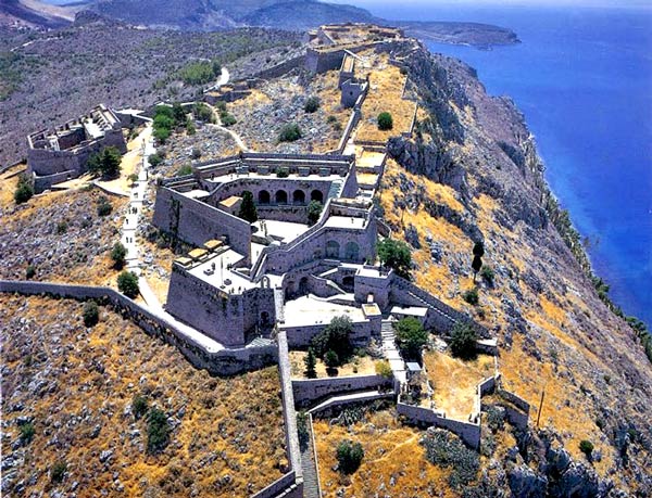
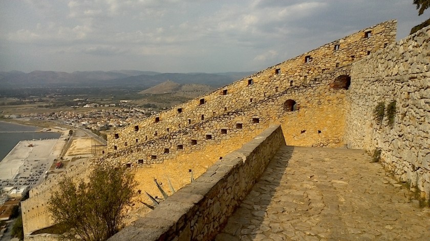
Nafplio is 33 km away from Astros and is a vast museum with many attractions and historical monuments. The most important are Kapodistria Square and Palamidi Castle, where the prison of the old man of Moria is located .
In the castle of Palamidi is the prison of the old man of Moria. In the background on the left is the entrance of the dungeon, which when you go down the stone steps out of emotion and awe catches your breath. The stone steps lead to the place, where with his tsarouchia the iron-clad old man of Moria dug the rock out of his anger for the Kotzabasides.
We welcome the anniversary events to celebrate the 200th anniversary of the Greek Revolution.
In the first very important victories of the Greek fighters of 1821 in Valtetsi, Vervena and Doliana, the fate of the liberation struggle was decided and the way was opened for the liberation of the enslaved Tripolitsa, which was the most ingenious and grandiose plan of the Elder of Moria, final success of the match. Typically before the battle of the Doliana and the Berbena, the Greeks said “the Turks are coming” and hid and after the decisive victory they said “where are the Turks” to slaughter them. The “Turkophagus” with his blood-stained sword raised high chased the Turks to Tripoli, shouting loudly “Persians, stand up and fight”. In fact, in historic Vervena and historic Doliana, “Moria’s roads were closed” so that we can be free today. “
On May 12 and 13, 1821, a decisive battle took place in Valtetsi, Arcadia, between Greeks and Turks. This was the first “regular” battle, which lasted 23 hours according to Theodoros Kolokotronis who was the leader of the Greeks. Our ancestors achieved a great victory which gave them great confidence, as they were convinced that they could face the Turks. If the Turks won the battle of Valtetsi, the future of the Revolution was bleak. Kolokotronis writes in this regard: “That war (in Valtetsi) was the salvation of Greece”.
The defeat of the Turks in Valtetsi meant, among other things, the failure of their plan to advance to Messinia from the road to Megalopolis. Their defeat had to be offset very quickly by a victory. Just five days later, Mustafa Bey Kehajabeιs, who was the leader of the Turks in Valtetsi, decided to campaign against the Bervena camp, which he considered an easy target as it was more isolated than the rest. He believed that the camp would be disbanded and the Turks would reach Mystras and from there to Messinia to quell the Revolution. But even in case of their defeat, the road to Argos and Corinth would be open for reinforcements to come down from the Eastern Mainland.
On the night of the 17th to the 18th of May 1821, Kehagiabeis started from Tripoli with a large force (4,000 men and cannons, according to Sp. Trikoupis), with the aim of disbanding the Greek camp at Vervena.
When he reached the Rizes, Kehagiabeis divided his force into three phalanxes.
The first phalanx attacked Vervena.
The second phalanx attacked Doliana, with the ultimate goal of attacking the Bervena camp from the southeast.
The third phalanx (mainly cavalry) attacked Dragouni. With a plan to join later with the other forces fighting in Vervena.
The liberation of the nation is not donated but is won on the battlefields with the blood of our heroic ancestors who practically did their patriotic duty. Unfortunately in Dragouni on May 18, 1821, the Turks with the supremacy of the cavalry defeated the Greeks and there the Agiannitis chief Panos Zafeiropoulos Georgakis Digenis and 17 Agiannite fighters were killed. Panos (Akouros) Zafeiropoulos this day participated in the battle of Vervena.
Nikitaras had passed through Doliana but as soon as he was informed that Mustafabei’s men were attacking the village, he returned there together with his brother Nikolas Stamatelopoulos and they were fortified in 13 stone houses. Another 100 men from Agios Petros Kynourias rushed to his side while two local chiefs Mitromaras Athanassiou and Elias Konstantopoulos joined forces with those of Nikitaras.
Kehagiabeis had more than 2,000 men, most of whom were Turkalvans
Kehagiabeis made the church of Agios Georgios his headquarters and after placing his cannons in key positions he started shelling the village of Doliana to disperse the defenders. The houses of the Doliana proved to be durable and the Greek warriors, motivated by Nikitaras, fought bravely. In fact, a fighter from Varvitsa killed the Turkish chief gunner. The battle continued but the same was happening in nearby Vervena.
There were about 2,500 warriors in the Vervena camp, led by Panagiotis Giatrakos, Antonis Mavromichalis, Anagnostis Kontakis and Panagiotis Zafeiropoulos. Vresthenis Theodorito
Panagiotis Giatrakos initially tried to hit the Turks when they arrived in Vervena but in an unguarded place. So his effort did not pay off. Gradually the siege around Vervena narrowed especially when it reached the section that passed through Dragouni. Soon the Turks occupied the hill above the village and raised their flag (the flag as it was called then) on it.
However, they were not happy with their success, because two excellent Mani snipers promised to kill the bayraktar (= the flag bearer), after first receiving as a reward 10 bullets (ie cartridges) each and the wish of the despot Theodoret. That really happened. The people of Mania killed the flag bearer and threw down the flag. Another bayraktar raised a second flag, but the Mani killed him as well.
This event gave courage to the Greeks, while on the contrary the Turks considered it a bad omen. So they decided to leave, fearing a catastrophe similar to that of Valtetsi. Then they were attacked by those imprisoned in Vervena. According to the prevailing version, they were fortified in a church between Vervena and Doliana. The battle lasted from 9 to 11 in the morning. Nikitaras and his men from Doliana had also come to the scene of the conflict.
The Turkalvanians were forced to retreat to Doliana, where they continued the battle until 2 after midnight. Exhausted, they fled and disappeared in the plain of Tripolitsa. There, however, some brave Greeks were waiting for them and beating them, because it was “deep darkness and the mortals could not be distinguished from the enemies”. A sudden rain saved them from slaughter.
The losses of the Turkalvanians were not very great. Spyridon Trikoupis writes about 70 dead, while Anagnostis Kontakis, who took part in the battle, states that the enemy losses were greater and that the main battle took place in the gorge between Vervena and Doliana and lasted all day. The losers left many spoils on the battlefield.
The battle of historic Vervena and historic Doliana on May 18, 1821 thwarted the dismantling of the Bervena camp and the plan of the Turks. It also boosted the morale of the revolutionaries and paved the way for the liberation of enslaved Tripoli.
The Turks after their defeat in Vervena and Doliana were permanently closed in Tripolitsa. The old man of Moria was undoubtedly justified and began to “close the armies of Moria”… for the consequences.
Undoubtedly, the “camp of the Berbens” played a catalytic importance for the organization and success of the liberation struggle. It is no exaggeration to say that the “camp of the historic Berbens” started the liberation of our homeland, both militarily and militarily.
Nikitaras gained great glamor and then he was given the nickname “Turkophagus”. In a way, he took revenge on his father and his eleven-year-old brother John who were massacred in Monemvasia in October 1816.
Nikitaras, whose real name was Nikitas Stamatelopoulos, was born in 1782 in Megali Anastasitsa (today Nedousa, Messinia). His mother was the sister of his wife Th. Kolokotronis. His bravery and contribution to the Struggle are well known. His selflessness was also special. Only once, after the battle of Dervenakia, did he agree to take a valuable sword from the rich booty, which he later offered to a fundraiser for Messolonghi.
After the Revolution, he was imprisoned because he was considered the leader of the “Orthodox Society” (December 1839). He was tried and acquitted on July 11, 1840, but the Government did not release him then, but only on September 18, 1841. He was almost blind as he was suffering from diabetes. After his release from prison, he was given a “begging permit” every Friday in Piraeus, where the church of Evangelistria is located today. After 1844 he was given the rank of Lieutenant General by Otto along with a meager pension. He died on September 25, 1849.
From the “Mount Parnon and Moustos Wetland Management Agency, 2015. Guide for the protected area of Mount Parnon and Moustos Wetland. Nature, Culture, Ecotourism. Astros of Arcadia
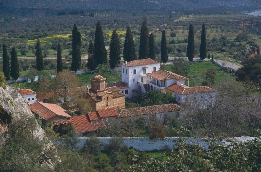
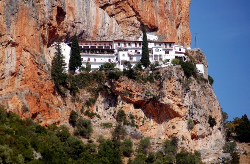
Loukous Monastery is one of the most important living monasteries in Arcadia. It is located on the road between Astros and Kato Doliana and is 4 km away from Astros. 205), while the river Tanos flows opposite it.
According to archeological findings in the wider area, the monastery seems to have been built near or on the site of ancient settlements. Here was also the sanctuary of Asclepius and the sanctuary of the Warrior. The various sections of ancient buildings, as well as the descriptions of statues or architectural members found in its area, confirm that Loukou was the sacred place where a wonderful composition of ancient Greek and Christian culture could be created.
Many views have been expressed on the name Loukou. According to them, A. Orlando and G. Sotiriou, there were probably many wolves in the area and initially the monastery was named “Lykou”. According to G. Konstantopoulos, the name probably came from the “gullies”, ie the canals that exist in the monastery. Another hypothesis, recorded in code by the abbot Joseph Coralli, the place name may be of Latin origin from “Lucus Feroniae”: the forest, where Herod’s mansion was inside. Forest full of prey, springs, plane trees (“Lucus” in Latin means sacred forest, grove, forest).
The monastery has been called “of Luke” since at least the beginning of the 17th century, confirming the existence of its cruciform status. The year 1649 AD is recorded as the year of the hagiography of the temple, probably, according to its scholars. Other important dates for the monastery are: in 1730 AD, when Abbot Fourmont destroys hundreds of valuable testimonies, inscriptions, statues, as well as works of speech and art of the monastery, so that only he has the privilege of copying them! In 1826 AD, Ibrahim ordered its cremation and thus gold bullion, precious heirlooms and valuable documents were destroyed. However, the katholikon was saved from destruction, as well as the wood-carved iconostasis and the sacred icons, which were fled by the fathers of the monastery. The monastery of Loukos in its modern form generally maintains an impression of harmony, picturesqueness and beauty. The large rectangular building complex, which surrounds the Luke Cathedral, gives it a fortified character. In the courtyard of the monastery there are many capitals of Corinthian and Ionian type, marble bases of columns and amphitheaters, capitals of pilasters, entablatures and columns. Other architectural members are built as decorations in the church, mainly in the SE vertical wall and in the other buildings of the monastery. At the beginning of the 19th c. The monks collected ancient sculptures and placed them in the courtyard of the monastery, while later, the most important ones were transferred to the National Archaeological Museum. In 1977 the Hellenic Archaeological Service carried out excavations in the area, with significant results. The inner courtyard of the monastery is dominated by the katholikon, which has decorated the SE sides, with early Christian and ancient Greek architectural members and there is a strong imitation of a brick-enclosed building. It is a masterpiece of architecture and temple construction. It is of the four-column type, a complex inscribed cross with an octagonal dome and has three three-sided arches of a sanctuary on the east side. Inside there is the so-called four-chamber and the four corner smaller apartments that are housed with shields. According to recent research by both M. Hatzidakis and C. Bouras, the katholikon of the monastery belongs to the post-Byzantine temples in imitation of Byzantine models. The katholikon is recorded internally with frescoes by an unknown artist, which, although they bear traces of history, such as damage to the faces of the depicted saints, are, for the most part, preserved in excellent condition. The monastery maintains a rich library where manuscript codes and patriarchal documents are also kept. One of them on film is by Gregory ED. The catholic of the monastery is dedicated to the Transfiguration of the Lord and celebrates on the 6th of August. Early Christian iconostasis colonnade (left of the door)
From the “Mount Parnon and Moustos Wetland Management Agency, 2015. Guide for the protected area of Mount Parnon and Moustos Wetland. Nature, Culture, Ecotourism. Astros of Arcadia “.
Pera Melana
Pera Melana, built on the slope of Mount Parnon at an altitude of 200 µ., Is 7 km from Tyros and 13 km from Leonidio. It is a village that has been characterized as a traditional settlement and most of its inhabitants speak the Tsakonian dialect. It consists of two districts, Livadi and Dernikeika. Between the two neighborhoods is the church of Panagia which is honored on the 15th of August.
In Pera Melana the visitable for the common Folklore Museum is housed in a beautiful traditional stone building, where the old school of the settlement operated. The museum includes local Tsakonian costumes, local textiles, the famous Tsakonian tagaria that were made with great skill by the weavers in the village, typical local costumes, photographic material, traditional everyday objects and tools, etc. In the sanctuary of Apollo Tyritas at the top of the Prophet Elias Melanon, a square altar and a retaining wall of the 4th c. e.g. The worship in the sanctuary of Tyritas began in the 8th c. e.g. and was more intense in the 7th, 6th and 5th c. e.g. with a glimpse of the 4th century. Tyritas was probably an old local deity who helped produce milk and cheese, but over time he was identified with Apollo, keeping the old name as an adjective. Its sanctuary experienced the greatest prosperity of all the sanctuaries of the region in the archaic period, perhaps due to its central location in Kynouria
From the “Mount Parnon and Moustos Wetland Management Agency, 2015. Guide for the protected area of Mount Parnon and Moustos Wetland. Nature, Culture, Ecotourism. Astros of Arcadia “.
Traditional Tsakonian settlement at an altitude of 200 m. Pragmatefti used to be called “Capital”, because it was the largest of the surrounding settlements. It was inhabited about 350 years ago and is located 9 km northeast of Leonidio. The Ionian inhabitants of the village are engaged in agriculture, animal husbandry and fishing. Because they traded their production themselves, they called them “Pragmateftides” and their village Pragmateftis.
Pragmatefti includes two settlements:
a) Sampatiki, a picturesque fishing village with a small harbor and a very beautiful beach with sand and fine pebbles. The name Sabatiki came from the phrase “as you go there” or from its cape called Savatiko.
b) Livadi, a seaside fishing settlement located immediately after Sampatiki in the direction of Tyros. West of the village there is a small basin, the Lakes, where the ruins of an older settlement are preserved.
In the center of Pragmaveti there is the church of Agia Triados, in the cemetery the church of Agios Ioannis of the 18th century, in Limnes Agios Georgios, in Livadi Agia Paraskevi and in Sampatiki Panagia, to the east of which are preserved ruins of old buildings (cells and auxiliaries spaces). Characteristic of the village are the beautiful stone houses, the clean streets of island character and the unrestricted view to Myrtoos, the Argolic gulf and the fertile fields of the area with olives and citrus
From the “Mount Parnon and Moustos Wetland Management Agency, 2015. Guide for the protected area of Mount Parnon and Moustos Wetland. Nature, Culture, Ecotourism. Astros of Arcadia “
Municipality of Tyros
The Municipality of Tyros was a municipality of the prefecture of Arcadia that was created in 1993 with the merger of the former Communities of Tyros and Sapounakaika, which are residential and constitute the town of Tyros. In 1997, with the “Ioannis Kapodistrias” program, the former Community of Pera Melanes was added to the Municipality of Tyros, constituting the Municipal Department of the Municipality of Tyros. It operated in the period 1993-2010, when it was abolished with the implementation of the Kallikratis program and joined the new Municipality of South Kynouria as a Municipal Unit of Tyros, with a total population of 1,779 inhabitants, according to the 2011 census. The seat of the Municipality is Leonidio. It is located in the east of the prefecture and is bathed by the Argolic Gulf and the Myrtos Sea. It is 180 km from Athens, 20 km from Leonidio, 30 km from Astros and just 14 nautical miles from Spetses.
Tyros, one of the oldest naval states of the Peloponnese, belongs to the area of historic Tsakonia, where the Tsakonian dialect is still spoken. The town of Tire has been characterized as a traditional settlement and enchants the visitor as it impressively combines mountain and sea. It has a modern tourist infrastructure and in its modern port tourist boats of all types can be moored. At 18 km of coastline it has many beaches: the coastal settlements of Kryoneri and Tserfo on the road to Agios Andreas, the small resort of Agios Christoforos and the beautiful beach of Zaritsi located in the bay of the same name. Nearby are the beaches of Livadi, Kissakas, Lygeria, as well as Tigani beach at the end of the pine-covered slope. At the edge of this beach is the “cave of lovers”. At the southern end of the port, at the top of the rock, above Lygeria beach, there are three windbreaks built around 1920, with a wonderful view to the sea.
Tyros has been inhabited since prehistoric times. Remains of an ancient settlement and cyclopean walls are located at the top of Kastro hill, above the current port. Ancient finds have been found on the Paliochora plateau of Tyros and on Mount Orion (1,194 m.), Which are now in the museums of Sparta, Tripoli, Astros, the Benaki Museum, as well as the Louvre museum. In the place that today is the chapel of the Prophet Elias, on the homonymous hill, are the ruins of a temple dedicated to the god Apollo Tyrita, a local deity who was worshiped in the area and who probably gave its name to Tire. In Tyros every Easter you will see some of the most beautiful Easter customs of Greece. On Good Friday the epitaphs are processed on the coastal road of the town accompanied by the boats of the fishing fleet, on Holy Saturday night at the time of the Resurrection the burning of Judas in the sea on a floating platform (See p. 272). On Easter Sunday, the Tsakonian feast takes place in the central square, with the reading of the Gospel in the Tsakonian dialect. Several events and festivals are organized in the area. In Tyros Beach, Agia Marina on July 17 (image procession) and Several events and festivals are organized in the area. At Tyros Beach, Agia Marina on July 17 (image procession) and the Transfiguration of the Savior on August 6, Agios Christoforos on May 9 (Zaritsi), Agios Ioannis on June 29 (Paliochora), Profitis Ilias on July 20 at homonymous chapel of Agios Panteleimon on July 27 (Stenoma) and Agios Dimitrios on the first Sunday of September (Soha). On the plateau of Paleochora of Tire, at an altitude of 755 m., Is the sink of Dersios known since antiquity, which in recent years has been explored by foreign and Greek speleologists (See p. 134).
Leonidio is about 50 km from Astros, 220 km from Athens and 250 km from Athens airport. On the Astros Leonidio route there are many enchanting beaches where “the sun and the sea of the Argolic” are in their grandeur.Leonidio is today the capital and the center of Tsakonia. At a close distance from Leonidio about 17 km is the holy monastery of Elona, which as a symbol of Tsakonia is hung and inaccessible to the red rock.
From the “Mount Parnon and Moustos Wetland Management Agency, 2015. Guide for the protected area of Mount Parnon and Moustos Wetland. Nature, Culture, Ecotourism. Astros of Arcadia “.
The Tsakonian dialect, the Tsakonian dance, the costume, the customs and traditions of the Tsakonians, are another dynamic of the Parnon area. According to the “Chronicle of Monemvasia”: “And the prefectures and peasants of Thremte were settled in the rugged places adjacent to it, and finally the jaconia were named”. The Tsakones, as true descendants of the Dorians, kept their roots intact and the Tsakonian language is still the living expression of the Doric dialect. In the cradle of Tsakonia, today insists on walking and creating in the footsteps of yesterday in a perpetual and uninterrupted breath of Greece.
The special linguistic treasure of our place. The Tsakonian dialect has been included in the list of endangered languages of UNESCO and is recognized as a cultural achievement and a unique treasure of culture. The language was preserved genuine and unadulterated in the mouths of ordinary people, peasants, shepherds and farmers. In the wishes, in the greetings, in the curses, in the everyday expressions, in the teasing and the jokes, there is for centuries now the linguistic treasure of the Tsakonians. In this special part of the Greek land called Tsakonia (the cradle of Tsakonia was Prastos, Kastanitsa and Sitaina), in these rugged places, the inhabitants of the area, with few means, not only survived, but left behind a precious heritage, the Tsakonian tradition, the beautiful language, the unique evocative Tsakonian dance, the Tsakonian songs, the weaving art, their habits, what we call today customs and traditions. All this composes the identity of the place with a living language that is in the hands of the Tsakonians, but also of all Hellenism, to embrace it and protect it from oblivion
Leonidio, the capital of the sea, with a long naval history, is located at the beginning of the valley of the river Dafnonas (known since antiquity as Selinountas). It is built at the base of imposing red rocks that are a natural observatory with unrestricted views of the sea horizon. According to the 2011 census, it has 3,826 inhabitants, mostly Tsakones, with a strongly developed religious sentiment. The riverbed passes through the middle of the city like Psandros and continues to flow through its fertile plain ending in the sea of the Myrtos Sea. It is 93 km from Tripoli and 200 km from Athens. Leonidio took its name from the small church of Agios Leonidas, which refers to a gold bullion of Andronikos BI Palaiologos, in 1293 and in Tsakonian it is called “Agielidis”. It has been characterized as a traditional settlement and a historical place with two-storey and three-storey mansions with paved and pebbled courtyards, flat tiled roofed porches, high whitewashed stone walls and carved and painted, carved and painted visitor For a first taste of the local architecture.
In Leonidio are saved three of the most majestic pre-revolutionary Funerals of the Peloponnese. The tower of Tsikaliotis (1808), which from time to time hosts art exhibitions and events, is one of the oldest preserved buildings in the Peloponnese and is accessible to the public (See photo p. 367). Inside it has a nice wood paneling and a huge fireplace. Second is the mansion of Polytio (1816) and this preserved and third important building is the mansion Katsikogianni (1807), located at the northern end of the house. The Hatziroudis tower is also interesting. A real gem is the six-grade Kallia primary school, which has been operating since about 1910, while the new gem of Leonidio and the area is the “Fabrika”, the building of the Center for the Promotion of Rural History and Sea Roads in the Eastern Peloponnese. with a long and multifaceted history.
Remarkable and of historical importance are several churches of the city, such as the Diocese (the Annunciation of the Virgin) with important icons of the 17th century, Saint Catherine, Saint Kyriaki, the Three Hierarchs, the Saints Taxiarches and Panagia Hatzaliou. On a green hill south of the city is the church of Prophet Elias, which celebrates with a festival in the summer. On a hill that dominates the city, to the right of the eastern entrance, are preserved three characteristic traditional windmills.
At 4 kg. from Leonidio is the port of the city, Plaka, with its picturesque port. There is a beautiful organized pebble beach near the port, as well as luxury accommodation, rooms to let, organized camping, restaurants and taverns with seafood delicacies. From the cape of Pelia, located a little north of the coastal settlement of Lakkos, to the port of Plaka, stretches a flat beach (2 km long) with coarse sand and pebbles. South of Plaka starts a rocky but gentle shore, which is suitable for underwater fishing.
The ancient name of Leonidio is Vrasies or Prasies, whose location was above the port of Plaka, on the hill with the chapel of Agios Athanasios. Plaka is today the port of Leonidio. Here, according to mythology, the sea in Larnaca washed away the unprotected little Dionysus, who was received by Ino and hid in the Cave of Sintza (See p. 128) and since then it is called the cave of Dionysus.
Leonidio, the “safe place” according to Theodoros Kolokotronis and the “Dionysus garden” according to Pausanias, is the homeland of the painters Nestoras Varveris and Vrasidas Tsouchlos, the poet Costas Ouranis, George Sarantaris, Elisabeth Ps. It is the homeland of many fighters, shipowners and financial sponsors and military leaders of the Struggle for Freedom of 1821. When Ibrahim’s Egyptian army in 1826 destroyed the historic capital of Tsakonia, Prastos, its inhabitants fled to Leonidio, where it began to develop. The once isolated Tsakonia, tightening its ties with the major urban centers of Europe and the East, smells the wind of freedom that blows from the West and due to its strong economic position, leads the Greek Revolution that shocks the Ottoman Empire. It is worth noting that the armament of Leonidio and the whole of Tsakonia played a very important role not only for the development of the region, but also contributed decisively to the Revolution of 1821.
The cape of Leonidiο produces a variety of agricultural products, citrus fruits, olives, tomatoes, lettuce and other vegetables. A typical product of the region is the Eggplant (Tsakonian, as it is known), which is sweeter than other varieties, mainly due to the climate and soil and is famous as the most delicious in Greece. At the port of Leonidio, Plaka, at the end of August, the “Festival of the Tsakonian eggplant” has been established (See p. 279) while in Leonidio is also organized the now famous Melitazz Festival (See p. 270).
Easter in Leonidio is impressive (See p. 271), so much so that Dimitris Psathas once wrote: “Carnival in Patras and Easter in Leonidio”. At a distance of 5 km from Leonidio, west on a rock, is the monastery of Agios Nikolaos Sintzas (See p. 192).
In all the great battles and sieges the rebellious Tsakones give the thunderous present. It is said that they fought and shouted: “The nutcracker of the tanu is jealous of the saddles, and Eona is guarding the tsakonops”. That is, “The nutcracker thunders on the saddles, Elona to guard the tsakonopoulos.”
History
Due to its fortified location and available water, the site of South Kynouria flourished during Mycenaean times. Typical vaulted tombs have been excavated in Paleochori, Leonidio and Vaskina, while the Greek leaves of the Dorians, Achaeans and Ionians were mixed here. From the end of the 11th century BC. and until the arrival of the Romans the land of Kynouria was incessantly claimed from Argos and Sparta. The Kynourians cross the Mediterranean, reach and meet Taranto and the shores of the Marmara Sea. This explains the preference of the Byzantine emperors for the Tsakonian warriors, since they knew their devotion and their ethos. During the period of Roman rule the area developed peacefully. The Tsakonians have been known by this name since the years of the Byzantine Emperor Constantine VII, forming during these years a separate military corps.
From the “Mount Parnon and Moustos Wetland Management Agency, 2015. Guide for the protected area of Mount Parnon and Moustos Wetland. Nature, Culture, Ecotourism. Astros of Arcadia “.
The Tsakonian dialect of Leonidio, Pragmatefti, Melana, Tyros, Sapounakeika, Agios Andreas, Prasto, Sitaina, Kastanitsa is spoken. Settlements: Sampatiki, Livadi, Vaskina, Paliochora, Agios Panteleimonas (Bubble), Dernikeika
The Tsakonian dialect
The Tsakonian dialect, the Tsakonian dance, the costume, the customs and traditions of the Tsakonians, are another dynamic of the Parnon area. According to the “Chronicle of Monemvasia”: “And the prefectures and peasants of Thremte were settled in the rugged places adjacent to it, and finally the jaconia were named”. The Tsakones, as true descendants of the Dorians, kept their roots intact and the Tsakonian language is still the living expression of the Doric dialect. In the cradle of Tsakonia, today insists on walking and creating in the footsteps of yesterday in a perpetual and uninterrupted breath of Greece. The special linguistic treasure of our place. The Tsakonian dialect has been included in the UNESCO World Heritage List and is recognized as a cultural achievement and a unique treasure trove of culture. The language was preserved genuine and unadulterated in the mouths of ordinary people, peasants, shepherds and farmers. In the wishes, in the greetings, in the curses, in the everyday expressions, in the teasing and the jokes, there is for centuries now the linguistic treasure of the Tsakonians. In this special part of the Greek land called Tsakonia (the cradle of Tsakonia was Prastos, Kastanitsa and Sitaina), in these rugged places, the inhabitants of the area, with few means, not only survived, but left behind a valuable heritage, the Tsakonian tradition, the beautiful language, the unique evocative Tsakonian dance, the Tsakonian songs, the weaving art, their habits, what we call today customs and traditions. All this composes the identity of the place with a living language that is in the hands of the Tsakonians, but also of all Hellenism, to embrace it and protect it from oblivion
Tsakones friends, Tsakones friends and Tsakonia friends
It is remarkable that the Tsakonian culture is kept intact and alive for 3,000 years. This is not accidental but it is due to the passion and devotion of our ancestors, to maintain and carry the flame of Tsakonia through the centuries. This passion and devotion to Tsakonia is as evident and alive today as ever, may you all be well. As neighbors and friends of Tsakonia, we admire you and thank you for inspiring us and giving us “the passion for Tsakonia”.
In our digital age we must quickly catch the train of history. The Tsakonian language has remarkably been preserved intact orally over the centuries but we all understand that we must participate in our digital age to more easily achieve more for our children. We must speak, but we must also learn to write Tsakonika and most importantly if we want to better maintain the flame of our ancestors, we must also teach our children to speak and write Tsakonika.
With everything you do every day for the Tsakonian culture, you inspired us to participate as we can and we know in this great and difficult effort.
On our website astrosgr.com/en we designed the section The Tsakones a “blueprint for a website” that with the offer of many others, m ore experts from us, can later be improved and become a useful e-book, for preservation, learning and promotion of the Tsakonian language. We all know “WRITINGS REMAIN”.
The goal is to write e-language courses in a series for students of the future and at the same time to offer other useful relevant texts about Tsakonia, the obvious and what we can. We will find the right volunteers, we can not do everything.
We do not intend here to replace Kostakis Defner or the Tsakonia Archive. We try to make something simple and easy to use, yet easily accessible on our mobile phones, which will help our new friends to easily come into first contact with the Tsakonian language, to learn five basic things and then find their way. The report will be there and will improve over time for an easy use for those who want. “In our digital age we must quickly catch the train of history.”
I’m sure you will take a look at the draft of the “Tsakones” page and submit your own suggestions so that we can make something better together with many others. We owe it to Tsakonia.
This draft is daring because personally we are not teachers and we do not speak Tsakonika but you stuck the disease “passion for Tsakonia” and we consider such a thing self-evident for everyone, that should have happened.
We throw the draft of the section The Tsakones – astrosgr.com , the idea and “what we can do” to all Tsakones, teachers, friends of Tsakonia and public organizations that I am sure will continue better than us. There are many ways to achieve that “we owe to Tsakonia”, we can still look for funding from the Ministry of Culture, NSRF and UNESCO. To put it bluntly, the Municipality of South Kynouria, the Municipality of North Kynouria, the communities of Leonidio and of course organizations that have done a lot of work, such as the Tsakonia Archive, have the first say.
Eventually we will succeed in our work, when we see an admirable website about the Tsakonians and the Tsakonian language, which sooner or later will be done by the competent organizations with the participation of all the friends of Tsakonia. We owe it to Tsakonia.
Take a look at the topics / categories on The Tsakones – astrosgr.com main page. We do not suggest changing what you are doing today, but continuing the same and more that you can do with the same passion. Just all this and much more than the existing ones we will organize and coordinate them into categories in the section “The Tsakones” for easy access by our friends.
The section The Tsakones – astrosgr.com will deal primarily with the documentation of the Tsakonian language.
Of course there will be questions that we will be happy to discuss.
“Thales was one of the most important scientists of all time”
Intellectual and financial freedom create the perfect conditions for a spiritual take-off.
The Ionians, were the Greeks of the first diaspora, became free from the established way of life and thought, and far from any influence of the old changed the course of history. Anxious and adventurous, they quickly became financially independent of trade with other eastern peoples, and created an environment that allowed them to challenge, encourage, and allow for questioning and rational explanation of everything.
Suddenly the world abandoned the myths and religions that dominated its thinking for millennia, from its appearance on planet earth, and began to think logically.
The right moment had arrived in the history of mankind for the so-called creation of the Greek miracle.
Undoubtedly Thales the Milesian influenced humanity more than any other human being, he gave us the word and the common mind, a useful tool to do everything right.
“Those early philosophers had one thing in common: they all believed that behind all the changes there was a certain element of primacy.
“Thus philosophy was liberated from religion. We can say that the natural philosophers took the first steps towards a scientific way of thinking and thus laid the foundations for the later development of the natural sciences.
“… ..This process resulted in a deep spiritual fermentation, as well as serious effects on the mental history of man. It is obvious, then, that the economic and social conditions that prevailed in Ionia led to philosophical reflection. “
“But in the Ionian cities of the 7th and 6th century BC. there was a powerful bourgeoisie dominated by merchants and sailors. They tried to explain the phenomena – beyond the mythical interpretations of the world – with logic and the determination of the natural causes. “
“The city that pioneered this movement was Miletus with its numerous colonies. The first philosophers lived there: Thales (640 or 624 BC – 546 BC) Anaximander (610 – 547 BC) and Anaximenes (570-526 BC).
Thales the Milesian (640 or 624 BC – 546 BC) is the oldest prosocratic philosopher, the first of the seven sages of antiquity, mathematician, physicist, astronomer, engineer, meteorologist and founder of the Ionian School of natural philosophy in Miletus. ”.”
“According to Aristotle, Thales was the first philosopher and philosophy begins with him.
Stagiritis states: They asked about the first principles and causes… but Thalis, the leader of the same philosophy of water, is a principle … (Asking about the first principles and causes is a philosophy
Aristotle, Plato and several other philosophers consider Thales the first philosopher in history. After all, his name is among those of the “7 sages of antiquity”.
Even in modern times, Thales maintains his… mathematics “prestige”. One of the most important mathematicians of recent centuries, Bernard Russell, had stated: “Western philosophy begins with Thales.” Of course, this statement can be justified, since Thales was one of the first scientists to deal extensively with the concept of “logic”, which was the main object of study of Russell. “
“The members of the school of logic believed that logic was the basis for any kind of argument. The main representatives of this school were Bertrand Russell ((Bertrand Russell, 1872-1970)
It would be more appropriate if we corrected Bertrand Russell and said better that world culture begins with Thales, since Western culture today undoubtedly has a significant influence on world culture.
“Thalis Milesios was a multifaceted personality. He studied astronomy and mathematics, physics and philosophy. Much is said about his scientific achievements and it is difficult to distinguish how many of them are not due to the legend created around his personality. He emerged as perceptive mentally and politically
Thales first sought the beginning of beings not in God, but in some natural species. Thales’s attempt to explain the nature and the multitude of natural phenomena, no longer with myth and religion, but rationally, places him historically in the first place of the ancient Greek philosophical tradition “
“Thales the Milesian, this great philosopher and very capable observer of Nature, tried to explain the origin of the Universe by inductive research, setting aside the myth. He assumed that the primordial element, the beginning and the basis of the Universe, should be one of the four basic elements in fish ”
First, then, Thales Milesius, founder of the Ionian School and founder of theoretical Geometry and Astronomy, as a bearer of the theoretical Greek spirit, which is not content with finding and memorizing data but seeks theoretical explanation and justification of facts. notion of “principle”, which has since been a key condition of the world scientific intellect “
… ”It is certain that Thales is rightly considered one of the most important scientists… ..This is because the Milesian mathematician was the one who actually gave the impetus for the mathematicians to start thinking in a …scientific way…. “, Gave the hands of later scientists a powerful tool.
Whether he believed that water, apart from being a cosmogenic principle, participates in the constitution of the world or not, the important thing is that the philosopher removes his divine property from water and recognizes it only as a physical body.
The most important thing, however, is that through his problematic for the beginning of the world he reduced the multiple phenomena of the world to an impersonal, unique or unified principle, a fact that classifies him justly in the chorus of philosophers.
Thalis is also known for the successful prediction of the solar eclipse of 585.
During his long journey, Thalis took care to transmit some of his knowledge to the neighboring peoples. In fact, when he was in Egypt, in front of the impressive spectacle of the imposing pyramids, he made sure to make his most famous measurement. No one knew the true height of the great pyramid of Giza, until Thales made a very simple and clever thought. Placing a bar next to the monstrous building, he waited for the moment of the day when the shadow would reach the same length as wood. At the same time, the height of the pyramid could be measured through its shadow. An eternal problem, unsolved even for the builders of the pyramid, had been solved in such a simple way “.
For 2,500 years our people, when they want to say that someone is very smart, also say that he is “Thalis” (the “Aristotle”) as a sign of appreciation and admiration for the great thinkers. This was said more daily for many centuries after his death. Like the 78th Panhellenic Student Competition (P.M.D.) in Mathematics it is called “O THALIS” and it is not called Archimedes, Euclid, Pythagoras, to show the great appreciation that everyone has in Thales until today.
The “company” of Thales, (the most important Prosocratic philosophers and other philosophers).
.O Anaximander
The next philosopher from Miletus is Anaximander (610 – 547 BC) Like Thales, he also had important knowledge in mathematics, astronomy and geography.
It is said that he made the first map of the world, contributed to the introduction of the use of the sundial in Greece, while he also made a celestial sphere for the convenience of sailors. Specifically, he created a global model of the heavens in the center of which he placed the Earth (geocentric model of the universe).
However, the interests of Anaximander far exceed those of Thales. In addition to mathematics, astronomy and geography, he is interested in meteorology, anthropology, biology, and even the history of civilization. His interests betray his real intention: He wanted to give a universal picture of the natural course of things from their beginning to their present phase.
The first such example in the history of science is undoubtedly the theory of Anaximander, during the 6th c. BC, that the Earth hovers in a vacuum, a theory that according to K. Popper “is one of the boldest, most revolutionary and most wonderful ideas in the entire history of the human spirit.” What is remarkable about this idea is that insight and logic led Anaximander to the correct conclusion that the Earth can not be supported anywhere, but must be suspended, while, on the contrary, the observation and experience that we are on a flat earthly surface “Clearness with the circular horizon around us was what led him to the misconception that the Earth is a cylinder (and not a sphere), on one of the flat surfaces on which man lives.”
Anaximenes (570-526 BC
The third philosopher from Miletus was Anaximenes (c. 570-526 BC). His views are considered a consequence and variation of Anaximander’s views to the point that he is considered – but without sufficient evidence – his student.
“Heraclitus the Ephesian was a Greek prosocratic philosopher who lived from the 6th to the 5th BC. century in Ephesus, in Ionia of Asia Minor 535-470 px or 544-484? ”
Democritus (~ 460 BC – 370 BC, ETYM arch., Initial note “the judge of the municipality”, dῆmos + -critus <judge) was a prosocratic philosopher, who was born in Abdera, Thrace. . He was a student of Lefkipos. He believed that matter consisted rom inseparable, invisible elements, atoms. He was also the first to realize that the Galaxy is the light from distant stars. He was among the first to mention that the universe has other “worlds” and even some inhabitants. Democritus made it clear that emptiness is not identified with anything (“non-being”), that is, it is something that exists. “
Protagoras (c. 490 – c. 420 BC), from Abdera in Thrace, was an important sophist of antiquity. He was a contemporary of Democritus, also from Abdera, a leader among the sophists and the founder of the sophistic movement. As a teacher he traveled to many Greek cities. He often visited Athens where he became friends with Pericles and other prominent Athenians. It is reported that Pericles commissioned him to write the laws for the Thurians, the Athenian colony in Lower Italy founded in 444 BC on the site of Syvar. [1]
“Epicurus (341 BC – 270 BC) was a Greek philosopher. He founded his own philosophical school, called Kipos tou Epikourou, which is considered one of the most famous schools of Greek philosophy “
Socrates (Alopeki, Ancient Athens, 470 BC / 469 [8] – Ancient Athens, 399 BC) was a Greek Athenian philosopher, one of the most important figures of Greek and world spirit and culture and one of the founders of the West. philosophy
Plato (Ancient Athens, 427 BC – Ancient Athens, 347 BC) was an ancient Greek philosopher from Athens, the most famous student of Socrates and teacher of Aristotle. His work, which in the form of philosophical dialogues has been saved in its entirety (even some incorrect works are attributed to him), exerted a huge influence on ancient Greek philosophy and in general on the Western philosophical tradition until today. The main builder of philosophy, the guide or forerunner of its later approaches, the inspirer directly or indirectly of the most important socio-political visions. [6]
Aristotle (Ancient Stageira, 384 BC – Ancient Chalkida, 322 BC) was an ancient Greek philosopher and scientist born in Stageira, Halkidiki, Macedonia. At the age of 17 he entered Plato’s Academy in Athens, where he remained until he was 37 years old. There he is associated with both Plato himself and Eudoxus, Xenocrates and other thinkers. [16] His works refer to many sciences, such as physics, biology, zoology, metaphysics, logic, ethics, poetry, theater, music, rhetoric, politics, etc., and constitute the first complete system in Western Philosophy.
Humanity has finally entered its course and the world has changed into its current form.