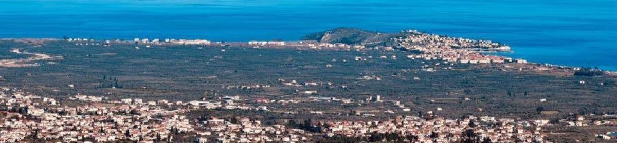
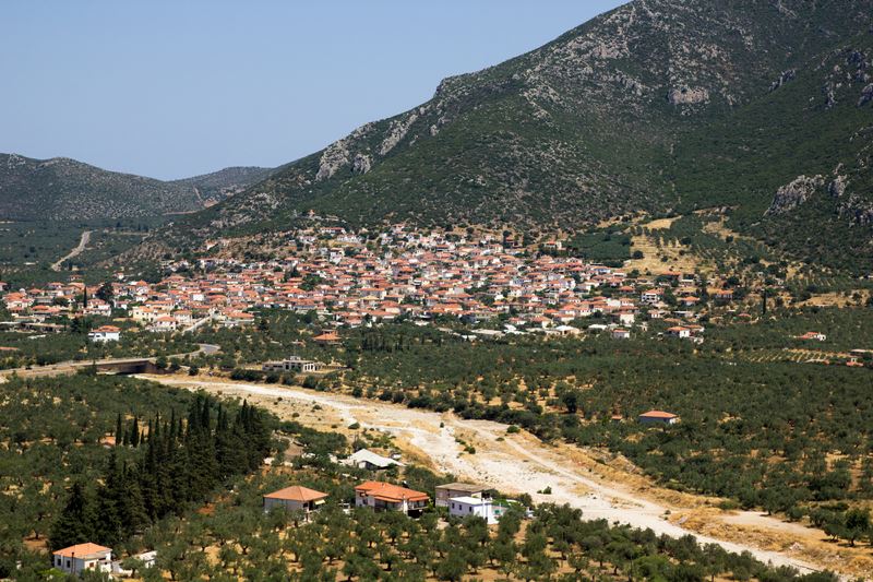
Astros is 170 km from Athens and Paralio Astros is 4 km from Astros.
The historical Astros Kynourias is located on the western beach of Argolikos, in the interior of the plain of Thyrea, where was the ancient city of Thyrea and later the polis Astron, south of the first city of Europe, the historic Argos and the seat of the Mycenaean civilization Mycenae.
On the map above, the historical Argos and Mycenae can be seen in the interior from ancient times, also later Astros and Leonidio are located in the interior. In recent years, also inland are the neighboring Agios Andreas, (from the settlement of Agios Andreas the Port of Agios Andreas was named, of course the ports are named after the settlements), Korakovouni, Meligou and Koutroufa.
It is obvious that the inhabitants in ancient times preferred the inner ones.
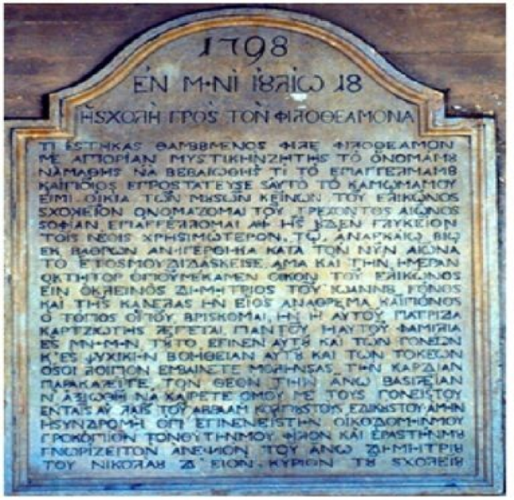
Astros existed thousands of years earlier, it was found there by the proxies of the National Assembly and Kolokotronis, “the National Assembly of liberated Greece met in Astros” said Alexandros Mavrokordatos, president of the Electoral Commission (i.e. Prime Minister), and “En Astrei”, “in Astros” the proxies did the obvious, and with the proclamation that was “Issued in Astros inside the Karytsiotis Museum” they proclaimed to the world and the powerful of the time “and let us become completely independent, a separate, autonomous and independent Nation”
The National Assembly did not take place to name the settlement Astros, on the first day of the National Assembly on March 29, 1823, Petrobeis Mavromichalis, Grigorios Dikaios i Papaflessas, Th. Negris, Panos Zafeiropoulos i Akuros, K. Zafeiropoulos, Bresthenis Theodoritos, G. Psyllas and about 80 other distinguished proxies. “In Astros on March 29, 1823 and third of Independence”, the Astros were found there by the representatives of the National Assembly.
It is wrongly stated that the Assembly in 1823 named the settlement Astros, because all the decisions of the Constitutional Assembly were made and had to be made in writing (it was a Constitutional Assembly, it was not a coffee house) and the Assembly did not decide with any document for the name Astros, simply and self-evidently used and officially confirmed the existing name Astros of the settlement, “in Astros” with the first documents from the first day on March 29, 1823, almost before the Assembly began.
At the current location of Paralio Astros , there was no settlement for thousands of years, because there were marshes, rushes and reeds. It was an “uninhabited place”, said Akοuros, and the island was a desert rock. It was the port of the area and in recent times before 1845 the name of the location was Skala or Skala tou Astros and in ancient times it was probably Pyramia or Apovathmoi . Leake mentions “Leaving the Scala of Astro= leaving the Scala of Astro, Travels in the Morea (p. 485). Leake in 1805 mentions and also confirms that there was no settlement at the site, “on the scala there is a tank, an inn, a tower house of the (Turkish) tax collector, and two or three small warehouses” (Travels in the Morea p. 482), as other historical scholars also report.
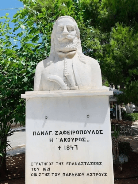
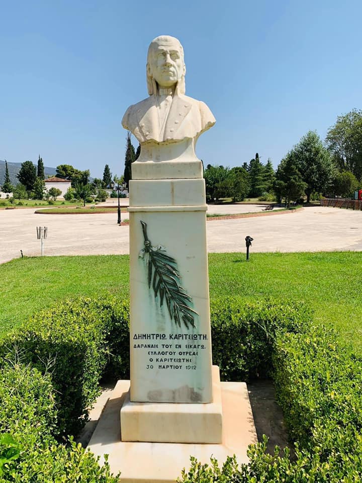
Paralio Astros is the newest settlement in the area and was built from 1832-1845 by the Agiannite general Panos Zafeiropoulos i Akouros, as the Paraliotes honor with his aridan in the central square, “SETTLER OF PARALIO ASTROS”. Paralion Astros Kynourias, Gazette 32A – 08/12/1845. The settlement is annexed to the municipality of Thyrea.
From “Castiello la Estella” (Castle of Astros) (1256), in Agianni of Astros, a part of the site “Xerokambi” can be seen in the background, “around the aegialon of Astros in the camp of Malevi”. (Adronikos II Paleologos). The photo from our friend and neighbor in the old “metropolis of Agiannis Soulinari” Thodoros Maglis.
The reference is official, of the Byzantine Emperor Hadronikos II Palaiologos (1259-1332 AD), he was the Byzantine Emperor (1282-1328), but the main thing is clear about the location, “around the aegialon of Astros in the camp of Malevi”, in “Xerokambi” of Agiannis Astros. (Adronikos II Palaiologos Chrysovulos (4) 1320 p.114), The mentioned land is Xerokambi, in the plain of the neighboring monastery of Malevi, in Agianni of Astros below the castle Estella (=Astros). Apart from the specific location “around the aegialon of the Astros in the camp of Malevi” he then refers to the interior of the mountainous Kynouria “around the place called Saint Nicholas…. the invoked bubble” and does not leave room for interpretations for another location. Some scholars strangely cut “in the camp of the Malevi” which most accurately describes the location and simply refer to the wider area “around the aegialon of the Astros” or incorrectly report a different location, because they do not know the location of the neighboring Malevi monastery ….
Holy Monastery of Malevi, is located in the east in Xerokambi of Agiannis, “in the plain of Malevi”, between Agiannis of Astros and Agios Petros.
It appears from the following official report of Hadronikos II Paleologus, in 1320 Agiannis was called Astros and also this report confirms the report of 1256 of the Chronicle of Moreos about the castle Estella (=Astros), which was located very close above Xerokambi, the “declared land of six hundred modius. they were, about the aegialon of the Astros in the camp of the Malevi”.
Below is the detailed account of the Byzantine Emperor Andronikos II Paleologus also by Nikos Vei.
He concedes to the monastery of Odegetria of Vrontochi in Mystra and to the abbot Pachomios various places among them “about the aegialon of Astros in the plain of Malevi about the holodomiko” and about the place called Saint Nicholas, about six hundred (5) (land)’ in the esti monydrio in the name of the venerated saint of Nicholas and enthroned fuska” Andronikos II Palaiologos in 1320 (Nikos Veis, Mneiai of Astros, p. 94).
: “… as well as the part of the above-mentioned land of six hundred modios. they were, the one about the aegialon of Astros, the one about the camp of the Malevi, the one about the cholodomitiko, and the one about the place called Saint Nicholas, .. and the said monydrio of Saint Nicholas also owns the said monydrio of Saint Nicholas, the invoked bubble after the exiles residents of this and others of these rights”. (Adronikos II Paleologos, Chrysovoulos (4) 1320 p.114).
The Byzantine Emperor confirms the name of the area is Astros (Agiannis), under the neighboring castle “Castiello la Estella” (Castle of Astros), which took the name Estella from Astros (as Agiannis was then called).
William Villardouinos built in Agios Ioannis (Agiannis) Kynourias, at the location “Xerokambi” (2 km) on a steep hill like a “natural pyramid”, “the castle, called “Castiello la Estella” (Castle of the Astros) (1256) ), for easier subjugation of the Tsakones neighbors in Sitaina, Kastanitsa and Prastos, where the Tsakones were, “up in the mountains” suso en law montanyas, as stated in the Chronicle of Moreos.
“And Astros was indeed two-sided even during medieval times… Agios Ioannis first had a status as a summer residence of Astrinoi called (above) Astros and Agiannis Astros, and later it became an independent village, when after the Alosin of Vasilevousis… And exactly on a single mountain above Agios Ioannis (=Epano Astros) lies … the Castle of Orias … In my opinion, after the above explanations, we can probably identify the Castle of Orias of Parnonos with Estella = Astros.(( Nikos A. Vei , Meniai of Astros 99-100).
“Central tower of Astros” (Castle Estella on Agiannis) By, Anastasios I. Ballas, Peloponnesian, Volume KG of the Society of Peloponnesian Studies, Prize of the Academy of Athens Astros (p. 209-210 Castle of Astros)
Leake 500 years later confirms the reference of 1320 by Hadronikos II Paleologus “the plain of Astros”, which is the Xerokambi of Agiannis.
“This road departs to the left of the Greek fortress (Castle Estella=Astros) which I saw from the plain of Astros, (i.e. from Xerokambi) which is two miles above the Ayiannite Kalyvia, then enters the cultivated plain of Xerokambi near Agiannis (Leake Travels in Morea, p. 492)
Everyone agrees and the Byzantine Emperor Andronikos II Paleologos the “Castiello la Estella” (Castle of Astros) (1256), is located in Agianni of Astros, in the location “Xerokambi”, above the “Astros in the camp of Malevi” In 1256 Guilielmos Villardouinos built in Agios Ioannis (Agianni) Kynourias at the location “Xerokambi” (2 km) on a steep hill like a “natural pyramid” “the castle, opera is called”… “Castiello la Estella” (Castle of Astros ) (1256) ), “to more easily subjugate the neighbors of the Tsakones in Sitaina, Kastanitsa and Prastos, where the Tsakones were, “up in the mountains” suso en law montanyas, as stated in the Chronicle of Moreos. (The photo from our friend and neighbor in the old “metropolis of Agiannis Soulinari” Thodoros Maglis)
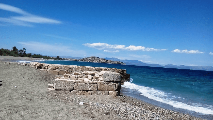
The Estella castle in Agiannis stands out like a distant star “up in the mountains” suso en law montanyas, as mentioned in the Chronicle of Moreos. Straight ahead in the distance is Argolikos and in the center on the small hill is the “island” which is the Paralio Astros Castle.
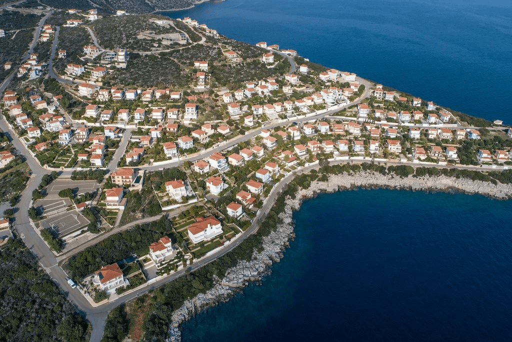
Not far from Astros, about 4 km, is Paralio Astros which has enchanting beaches and the “sun and sea” of the Argolic gulf is charming. Paralio Astros was built from 1832-1845 by the general Panos Zafeiropoulos and Akouros, as the inhabitants of the village honor with his statue in the central square, “SETTLER OF PARALIO ASTROS”. Paralio Astros, the amphitheatric coastal village of Arcadia with its picturesque alleys and traditional tile-roofed houses, intensively resembles a Greek Island.
“With the main feature of the area the” meeting “of the beautiful mountain with the sparkling sea, the Municipality of North Kynouria invites its visitors on a magical journey.”
From our Municipality
« One of the most famous summer resorts in the Peloponnese is experiencing rapid growth in recent years due to the short distance from the urban centers. It is 165 km from Athens and 49 from Tripoli. It has developed tourist infrastructure for every taste, kilometers of beaches with crystal clear waters and the possibility of marine activities. Area visitable all year round, ideal for weekends and three days. There is a Nautical Sailing Club in Paralio Astros, while there is a possibility of excursions to the islands of the Saronic Gulf and the villages of Kynouria. The picturesque natural harbor and the so-called “Island” by the locals with an incredible view of the Argolic Gulf are of special beauty. “Island” is the name of a part of the settlement that is built on the slopes of an asteroid hill. The houses in this part have retained their traditional color while at the top there is the famous medieval castle of Paralio Astros. Every summer in the small theater of the town there are many cultural events, while the sports activities are rich»
The most picturesque Paralio Astros, “the island” Paralio Astros, is perched on the hill and the ancients called the hill the “island”. Paralio Astros has nothing to envy from any Aegean island, it has it all, it is only two hours from Athens, it is very close “to the mountain” Parnonas, from its port the access to the “Aegean islands” is easy, is located close to the most important archaeological sites of our country and is very close to the historic Astros, the historic Agiannis and beautiful historical traditional villages.
For visitors Kynouria has a number of activities depending on the mood and physical endurance! Of course in summer the beaches of the area are full of life and invite the visitor to enjoy them. Portes, Atsiganos, Anavalos, Xiropigado, Heronissi, Arkadiko village and Kryoneri, are just some of the options we suggest! Those who wish to explore the beautiful waters of the area, can dive in the Arcadian village, Xiropigado and Paralio Astros.
“The Aegean Islands” are beautiful and offer many attractions that we all “must” visit. After all, it is not a coincidence that the prevailing view <the Greek name Atlantis helps this view> that in the Aegean existed about 12,000 years ago and Atlantis <Atlantis> which was the center of the world ….. There are many ways we can visit Aegean.
From the picturesque port of Paralio Astros in the summer there are many cruises to the “Aegean islands Spetses, Hydra
How to get there: From Athens airport follow the route to Athens, Corinth, Tripoli, exit to Argos (At the exit Sterna after Nemea), Argos, Tripoli (from the old road), exit to Astros (Left after the Mills), Astros.
Distances are from Astros, Paralio Astros is 4 km away from Astros
Astros is approximately 34 km from Argos, 33 km from Nafplio, 40 km from Tripoli, 48 km from Leonidio, 82 km from Sparta, 90 km from Mystras, 170 km from Athens and 200 km from Athens Airport.
In Astros and Paralio Astros there are many hotels and restaurants with traditional food, as in most neighboring villages.
Other options for Accommodation / Food: it is in Nafplio (33 km), in Tripoli (40 km),
Accommodation & Catering from the website of our municipality
For health issues there is the Astros Health Center in Astros, also many clinics and in Tripoli the Panarkadiko Hospital (see useful telephone numbers)
Schools, kindergartens: In Astros there is a kindergarten, elementary and high school, also lessons are given by private teachers for foreign languages and other subjects
Paralio Astros From Wikipedia, the free encyclopedia
«Paralio Astros is a seaside village in Arcadia. It belongs to the Municipality of North Kynouria and according to the national census of 2011 has a population of 1,043 inhabitants [2]. Formerly, the current existing Local Community of Paralio Astros (te as a Municipal District), was an independent Community, within the boundaries of the former Province of Kynouria
Paralio Astros Castle
The castle played an important role during the Turkish occupation. During the period of 1821, rich foreign merchants, brothers Zafeiropoulos (Konstantinos, Ioannis and Panagiotis), originally from Agios Ioannis, fortified the castle, building their houses there. On August 4, 1826, 1,200 soldiers locked inside the castle defeated the numerous army of Ibrahim who was besieging it. In 1833, Panos Zafeiropoulos (Akouros), dedicated the castle to the Kingdom of Greece and to King Otto. At the beginning of the 20th century, the castle was abandoned and deserted».
Panos Zafeiropoulos, was the most important Agiannitis before the revolution of 1821 and his contribution to Thyreatida Earth and his homeland is incalculable and went through the fine print of history.
“At the beginning of July 1826, the military corps of Panos Zafeiropoulos slaughtered 400 Arabs in an ambush set up by Mehmet aga of Tripoli. This was a very heavy blow to the Ottomans. That is why Ibrahim Pasha completely destroyed Agios Ioannis and the whole province of Agios Petros “
Ibrahim slaughtered and burned the whole Peloponnese, but he could never defeat Akuros, although he had been temporarily captured, not even in the castle of Paralio Astros, someone had to resist… and it is our great honor, this was Agiannitis Panagiotis Zafe Ακουρος).
500 books were saved from the burning of the School, which were kept in 1827 in the house of Zafeiropoulaia (Castle of Paralio Astros). These books were, according to tradition, placed in an old wooden library located in the offices of the School. Many of these books have been saved and recorded today. These books were mostly texts of ancient philosophers and writers, ecclesiastical texts, textbooks of physics, mathematics, etc. “
The settlement of Paralio Astros has a long history with the first important settlement by the Aeginians who were fortified in Paralio Astros in 424 BC. The construction of this fortification project was stopped by the Athenians, who at the same time, led by Nikias, came to Thyrea, captured it and destroyed it. But the Aeginians also settled in Agiannis, as historians report that the Aeginites came from Aeginites. Before the revolution of 1821 the Agiannites brothers Zafeiropoulos and many Agiannites made the second large settlement in Paralio Astros, and today many names from Paralio Astros are Agiannitika names.
“In November 1824, the Zafeiropoulos brothers began the restoration work of the ruined Frankish Castle of Paralio Astros and were completed in August 1825. More than 200,000 groschen were spent on the construction (according to a report by the widow Euphrosyne). The Zafeiropoulos brothers now settled permanently in the Castle and were the first settlers of Paralio Astros. Many Agiannites followed them and settled permanently in Paralio Astros, between 1825 – 1828 and later. These were mainly fighters who belonged to his military corps. The first Agianni families that followed the Zafeiropouloi were indicative: the family of Paschos, Logothetis, Nikolaidis, Maroudis (some of its members), Zafeiris (some of its members), Koralli, Bortzou, Diamantis, Karabatsou, Konstantinos, Vasilitheou, Vasileinos, etc., as well as the Avrantini and Nestora families from Spetses. We receive information about the first inhabitants of Paralio Astros from the memoir of Agiannitis Michael Logothetis, who was also the first president of Paralio Astros and from electoral lists of 1871 & 1881. “
Paralio Astros was built from 1832-1845 by the general Panos Zafeiropoulos and Akouros, as the inhabitants of the village honor with his statue in the central square, “SETTLER OF PARALIO ASTRO”.
By extension we can say that the inhabitants of Agiannis, Astros and Paralio Astros are almost the same inhabitants.
Administrative changes of the Local Authorities of D. Thyreas, Prefecture of Arcadia
Government Gazette 16A – 24/05/1835 Establishment of the municipality based in the settlement of Agios Ioannis
Government Gazette 5A – 08/03/1841 The settlement of Astros is defined as the winter seat of the municipality, The settlement of Agios Ioannis is defined as the summer seat of the municipality
ADMINISTRATIVE CHANGES IN SETTLEMENTS Paralion Astros (Arcadia)
With the actions of the Zafeiropoulos, the settlement named Paralio Astros was annexed to the municipality of Thyreas in 1845.
Government Gazette 32A – 08/12/1845 The settlement is annexed to the municipality of Thyreas
Government Gazette 252A – 24/08/1912 The settlement is detached from the municipality of Thyreas and is designated as the seat of the community of Paralio Astros
It is no coincidence that in the electoral list of 1871 of “Common. Paralio ‘Astros’ is mentioned first by Anastasios Paschos from Agiannis , a landowner.
See the links for more
From the Astros of the Sea electoral list of 1871
(Από το Άστρος της Θαλάσσης εκλογικό κατάλογο του 1871,1881)
“The Second National Assembly of the Greeks met in this place, March 30 – April 18, 1823”
Alexandros Mavrokordatos, president of the Electoral Parliament (i.e. Prime Minister), in a letter dated April 22, 1823 states. “It is a pleasant task for me to inform the Philhellenic Committees that the National Assembly of liberated Greece convened in Astros, in the bay of Nafplio” (Aristidedis N. Hatzis p. 121).
The “Sacred Space” of the Second National Assembly of the Greeks is undoubtedly one of the most important historical monuments not only of Kynouria, but also of our homeland. The anniversary of this event is celebrated with special splendor every year on Easter Friday.
The Greek state, recognizing the great contribution of the Karytsiotis School and the “Sacred Space” of the Second National Assembly of the Greeks to the Greek nation, declared it a “historic monument”, “historic site” and “archaeological site”. Astros Tuition
YA 47192/1433/11-6-1946 – Official Gazette 127/B/8-8-1946
“Let us declare as a historical preserved monument the lecture hall in Astra where the second National Assembly met in 1823”.
Characterization of the Karytsiotis school square and part of the farm, in Astros Kynourias, as a historical site.
HY Ministry of Defense/GDAPC/ARCH/B1/Φ30/65069/3340/1-8-2005 – Official Gazette 1194/B/30-8-2005
We classify as a historical site the remaining section of 18,850 square meters. of the old farm (total area of 46 acres), which belonged to the Karytsiotis School…
This area is part of the farm – originally 46 acres, which Dimitrios Karytsiotis had donated to the School, which he had founded in 1805 – planted with orange, lemon and olive trees, the product of which was used to pay the School’s teachers and covering its expenses.
In this farm, two important events of the Revolution took place, the known as the “Kolokotronis Table” on June 19, 1821, to which the chieftains had come, in order to overcome their differences and agree on the success of the Revolution that was starting at that time, as also the Second National Assembly of the Greeks (March 30 to April 18, 1823) with the presence of chieftains, politicians, masses of people and the army. Within the School, which is included in the area under declaration, the declaration of the National Assembly was drawn up”.
Nafplio, which had originally been chosen to hold the Assembly, was rejected as it was considered a “partial place”, i.e. party, under the absolute influence of Kolokotronis. Thus, Astros was finally chosen for the National Assembly as the “place of the Nation.” The meetings took place in the countryside, “in an orchard,” according to Kolokotronis.
The Archaeological Museum of Astros (Karytsiotis school building), the forecourt area of the school and the neighboring “Sacred Space” of the Second National Assembly of the Greeks are physically and functionally three separate spaces with their own particular historical significance, but harmoniously linked together, modest and imposing, it is an enchanting space, in itself a wonderful and unique “museum” that our visitors admire.
Members of the government began arriving at Astros in early March, but it took about a month for the proxies to arrive. The assembly began on March 30, 1823 in Astros Kynourias and lasted until April 18.
The decisions of the National Assembly were very important for the establishment and organization of the Greek State.
On April 13, 1823, the Provisional Government of Greece, the constitution which had been voted on January 1, 1822 by the First National Assembly of Epidaurus, was revised. The new Constitution was called the “Law of Epidaurus” (showing the continuity of the new Constitution with the previous one).
The Nation acquired a definitive Constitution, which, by decision of the assembly, was “the supreme law” and prevailed over the laws of the parliament. By decision of the assembly, the catalytic intervention of Kolokotronis, the anger of the people and the army, prevented the expropriation of the national lands – estates, which were left behind by the Turkish lords, which the kotzabasides of the assembly sought and wanted. The revised Constitution, extremely progressive and innovative for its time, contained liberal and democratic provisions that guaranteed the individual rights of the citizen. Public education was instituted, issues of religious freedom were resolved, the principle of free press was established, etc. The Criminal Code was also drawn up, based on Byzantine Law, to protect the citizen from the indecency of the authorities.
It gave the right of ownership to all persons who were in Greece, without restriction on their nationality.
During the Assembly it was decided to abolish the local organizations, the Messinian Senate in Kalamata by Petrobeis Mavromichalis, the Peloponnesian Senate in the Kaltezon Monastery, the Senate of the Western Peninsula of Greece in Messolonghi, by Al. Mavrokordatos and Areios Pagos in Salona, for Eastern Greece, from Th. Negri, so that there is a single center of authority and coordination.
One of the important points of the Second National Assembly is the abolition of the chief strategy, a decision which, although without mentioning his name, abolished the position of Theodoros Kolokotronis. The decision was considered as a declaration of the democratic state, in which all powers belonged to the representatives of the nation elected by universal suffrage.
“It was issued in Astros within the Museum of Karytsiotis,” says the proclamation of the National Assembly. The Astros Archaeological Museum is housed in the Karytsiotis School
Also important is the final text of the National Assembly, where the re-declaration of National Independence and the decision to continue the Revolution with every sacrifice is made.
The Assembly, following the standards of the Constitutions of the French Revolution of 1789 AD, drew up the “Declaration of the Second Greek Assembly”. The proxies of the National Assembly and Kolokotronis honored our great national benefactor Dimitrios Karytsiotis, “Was published in Astros within the Museum of Karytsiotos,” says the proclamation of the National Assembly. The assembly responded with the proclamation, to the world and the greats of the time. “We are determined to become independent, as an autonomous and independent nation.” a bit topical today…
The proclamation begins with the words: “The pro-independence national war of the Greeks has been going on for the third year already, and the tyrant has not been defeated either by land or by sea. While the tyrannical hands of the Greeks sent a myriad of Turks to hell, and they acquired fortresses and secured the territory, and the sound of the weapons, echoing, disturbed Byzantium, the nation was happy to proclaim in Epidaurus for the first time as a nation, its independence , to legislate and establish a national administration. Already after sixteen months, Second to convene in Astros Assembly.
DCIM\101MEDIA\DJI_0184.JPG
The “Sacred Space” of the 2nd National Assembly of the Greeks can be seen with the yellow line and the Courtyard of the Karytsiotis School with the blue line.
From the “Mount Parnon and Moustos Wetland Management Agency, 2015. Guide for the protected area of Mount Parnon and Moustos Wetland. Nature, Culture, Ecotourism. Astros of Arcadia “.
Korakouvouni, a lowland settlement built on a small hill next to the river Vrasiatis and the main provincial road Astros – Leonidi, is located 8 km south of Astros. It is a Kefalochori of the area with several stone-built mansions. In the center and the square of the village dominates the three-aisled Church of Agios Vassilios, Agios Georgios and Agia Varvara. Here are the busts of Georgios Leventis, who was a prominent Friend and head of the Tax Office of the Friends of Bucharest and the benefactor Georgios Kazakis. With a panoramic view of the settlement, the visitor can admire the lush olive grove that stretches in the plain of Vrasiatis and the blue-green beaches of the area. Mountainous Korakovouni at an altitude of 579 m., Is built on the slopes of Mount Parnon and at a distance of about 20 km southwest of Astros. At the entrance of the village the visitor meets the church of the Assumption of the Virgin built in the 17th century, the impressive three-fountain fountain with crystal clear waters built in 1886, in a beautiful paved and stone-built square surrounded by impressive centuries-old plane trees. The stone houses of the village combine harmonious elements of mountain and island architecture.
Museum of Traditional Olive Mill in Korakovouni:
The olive mill was built in 1884 by Petros P. Petropoulos and operated until 1920. It was biomobile, ie all processes were done by biological beings (a horse and workers) and not by machines. The olive mill was renovated in 2006 by Evangelos Anast. Petropoulos, grandson of the owner. In the museum the visitor can observe and get acquainted with the method of processing the olive for the production of olive oil, before the industrial modernization, presented by human models. The exhibits include the baskets in which the workers brought the olives, the sacks in which the olive pulp (commonly hummus) was placed to squeeze the oil, the millstone that melted the olives, the press where the pressing took place and finally the “libi” (container) that ended the olive oil and the other juices (liozoumia) of the olive. Among the museum’s exhibits are the cauldron that boiled the water they used to process the extraction of olive oil, the damizans that transported the oil, the liokoki and the stone wood that remained after the extraction of the oil. The museum also houses the “dynamari”, a mechanism for increasing the pressure of the presses, the plate that was bought in 1913 for weighing olives and oil and the office where the transactions were recorded. Of course, there are also additional tools of the mill, such as those of lighting (lamps) and tools such as the vise, scales, hand drills and wrenches. We will see the first screw of the press which was wooden, before it was replaced by the iron one. The area of the olive mill also served as a processing area for edible olives with salt that was made in the “lanza”, a large barrel with a capacity of 2.5 tons that survives to this day. Inside the museum there are agricultural tools of pre-industrial era, such as plows, zebras and goats.
The castle of Artikaina
Within walking distance from the village, the visitor deserves to know the medieval castle of Artikaina (See p. 208), in an imposing area with unrestricted views to the peaks of Parnon and the turquoise of the Argolic Gulf. At the initiative of local associations, a variety of cultural activities, events and festivals are organized every year. Of particular interest is the traditional carnival carnival, with unique hospitality and rich treats to the public, such as the famous traditional plate pie
Korakovouni, Arcadia
From Wikipedia, the free encyclopedia
Winter Korakovouni (also Karakovouni and Korakovounion) is a lowland settlement in the prefecture of Arcadia, built amphitheatrically on a hill at the foot of Mount Parnon. In a short distance flows the river Brasiatis. [3] It is located in the southeastern part of the prefecture, 52 km SE of Tripoli, in the former province of Kynouria. It belongs administratively to the municipality of North Kynouria. Korakovouni also includes the Mountainous Korakovounika and Neochori. Its history is lost in the depths of the centuries, as originally there was Mount Karakovouni (from Zaritsi Kynouria to Kastraki Astros) where in between there was only one settlement where it took the name of the mountain. During the Byzantine times, the General of Byzantium Pervainas came from Korakovouni or Karakovouni.
The name of the village has been associated with the Greek Revolution of 1821 as it is the birthplace of: • Varsami Konstantinou: He came from Korakovouni, Kynouria. Heavily injured f Agios Sostis, outside Tripoli. When he was healed, he continued to fight until his release. • Leventi, Georgiou: (Korakovouni, Kynouria 1790 – Athens 1847
Mountainous Korakovouni of Arcadia\
From Wikipedia, the free encyclopedia
Mountainous Korakovouni is a mountainous settlement, built at an altitude of 534 m. It is 12 km from Korakovounika and 22 km from Astros. T
he village belongs administratively to the Municipality of North Kynouria and has a population of 8 permanent residents according to the 2011 census The village, according to tradition, was founded after the destruction of Paleo Korakovouni (a settlement that existed near Prastos) by Turkish troops in 1687. [2] Along with Paleo Korakovouni, Agios Ioannis, Meligou, Kastanitsa and Prastos were also destroyed. After the destruction of the village, the inhabitants founded a new village in the place where the Mountainous Korakovouni is today. During the years of Ottoman rule the settlement belonged to the Vilaeti of Agios Petros. According to a Venetian census of 1699, the village had two churches: Agios Dimitrios and Panagia, as well as two vicars. [3] In the 18th and 19th the Korakovounites developed trade relations with various areas, as the Korakovounites lived and traded in places such as Spetses, Hydra, Constantinople, Odessa etc.
During the years 1750 – 1775 in the village acted the thief George Leventis (grandfather of the friend), who was the first son of Konstantis Kolokotronis. [4] With the founding of the Friendly Society, many Korakovounites became members, most importantly the merchant George Leventis (1790 – 1847). The contribution of the Korakovunites to the Revolution of 1821 was significant, as more than 100 fighters were distinguished in the battles of Doliana, Vervena, Tripolitsak. In 1826 the village was completely destroyed by the hordes of Ibrahim Pasha. After the liberation, the village was subordinated to the Municipality of Vrasia (1834 – 1912). From Korakovouni came the Winter Korakovouni, which was created during the 18th century. and is a permanent residence of the Korakovounites.
The village
Mountainous Korakovouni is a mountain village built amphitheatrically on the slopes of a mountain. It is overgrown with trees, while it has many traditional mansions that combine Tsakoniki with Spetsiotiki architecture. A marble point is the marble fountain together with the small square and the church of Panagia, located at the entrance of the village. The village has churches such as: of Agios Dimitrios (patron saint) in the central square of the village, building of 1688, of Panagia at the entrance of the village, which was the catholic of the Monastery of Panagia Katakekrymeni, building again of 1688. It also has chapels like of Agios John of the Forerunner in the place “Klima”, of Agioi Anargyroi in the place “Klima”, of Agios Georgios (former monastery of Endysenas), of Agios Ioannis the Theologian in the place “Cerbena” and the shrine of Profitis Ilias, above the village.
Orino Korakovouni also has a traditional cafe – tavern. Near the village are the villages of Korakovouni, Agios Andreas and the villages of Prastos, Kastanitsa and Sitaina. An important attraction is the Byzantine, ruined Castle of Artikaina, located east of the village. In winter the village lives with few inhabitants, while in summer it “comes to life” mainly during the feasts of Prophet Elias and the Fifteenth of August.
Leaving Agios Andreas, in the direction of Leonidio, the visitor meets the Arcadian Village, a modern and model settlement for expatriate Hellenism which was created with the main goal of reconnecting the ubiquitous Arcadians with their place of origin and strengthening Greek culture. their identity.
Beaches From our Municipality “
The homonymous beach of the model settlement of the Arcadian village on the road from Agios Andreas to Leonidio. It is located 1.5 km from the settlement. The beach is a small bay that extends 110 meters in length. Pebble beach. The waters are clear and not very deep. Access to the beach is via a path. The beach is not organized, but has toilets, showers and trash cans. Along the coast there are canopies of cloth on iron stakes. The maximum number of bathers is estimated at 150 people. “
The beach To Kryoneri “Magnificent beach, between Arkadiko Chorio and Tyros, with turquoise cold waters, rich pebbles and vegetation that reaches the water. Favorite beach of young people and those who feel young. It has a beach bar that gives rhythm to the summer holidays with party until morning and special events. It got its name from the springs that exist on land, one of which supplies water to the island of Spetses via watercraft – but also from the fresh water that gushes into the sea. The settlement has rooms to let and cottages. “There is an important underwater cave in the area for those who are engaged in underwater exploration and are looking for underwater emotions.”
The beach of Sampatiki Probably the most beautiful beach of Arcadia.
The name Sampatiki came from the obvious admiration of the neighbors who said “as you go there” you will see…. Sampatiki is 41 km from Astros and 26 km from the Arcadian Village Leonidio is 50 km away from Astros and the holy monastery of Elona 65 km.
From the Greek Travel Pages
“After Tyros on the road to Leonidio is the idyllic bay of Sampatiki on the south side of a small peninsula. With crystal clear waters and beautiful natural environment is probably the most beautiful beach of Arcadia. On the north side is the settlement of Livadi with a large nice beach. Sampatiki and Livadi are old fishing settlements and are inhabited mainly by the inhabitants of the nearby village of Pramatefti. The beach of Sampatiki with its picturesque port and beautiful small settlement is an attraction for many vacationers in summer. The small church of Panagia is located on the beach, while many fishing boats moor in the bay “.
From Wikipedia, the free encyclopedia
“Arkadiko Chorio is a settlement in the province of North Kynouria in Arcadia. It is built on a peninsula at Mikri Pepontina, after the village of Agios Andreas on the road to Leonidio. To the west rises the Parnon mountain range. It is 55 km east of Tripoli, 45 km south of Nafplio, 12 km south of Astros and 33 km north of Leonidio. It is a model and independent settlement that was conceived as an idea in the early 80’s by Arkades expatriates of America and began to be implemented at the end. It joined a national pilot program aimed at reconnecting Greeks abroad with their place of origin through the creation of holiday homes. “In the final phase of the program, 300-350 houses, a hotel, a conference center, sports facilities and other facilities were planned to be built, [2] but the Greek debt crisis has put its completion in doubt.”
Kefalochori of Tsakonia. With the tradition of the area preserved unchanged. It is 6 km from Astros and is located on the road to Leonidio. Village with constant population growth and tourist development with infrastructure and overgrown with olives and citrus fruits. The green settlement of Agios Georgios and the model settlement for the expatriates, the Arcadian Village, belong to its borders. The visitor can find rooms for rent, taverns, holiday centers, beaches with crystal clear waters and suitable for water sports. The village is characterized as a “gateway” for the picturesque Kastritochoria, since one can visit Kastanitsa, Prastos, while 5 km outside the village begins the unique gorge of Zarbanitsa. The visitor can also see the ruins of ancient Anthini near the port of Agios Andreas, the metochi of the Orthokostas Monastery which has a church dedicated to the Annunciation and a tall tower and the stone arched bridge over the river Vrasiatis. In the village also all seasons of the year festivals and cultural events are organized.
From the “Mount Parnon and Moustos Wetland Management Agency, 2015. Guide for the protected area of Mount Parnon and Moustos Wetland. Nature, Culture, Ecotourism. Astros of Arcadia “.
Agios Andreas, the main village of the area with stone-built, traditional houses, is surrounded by olive groves and citrus trees. The village is 9 km away from Astros and most of its inhabitants speak the Tsakonian dialect. In its typical paved square, in the center of the village, there are cafes, shops and restaurants. Special festivals are the festivals of Agios Panteleimon, Ypapantis, Agios Apostolos, Profitis Ilias and the rich Constantine and Eleni, while many cultural events take place throughout the year (music events, carnival, etc. .). .
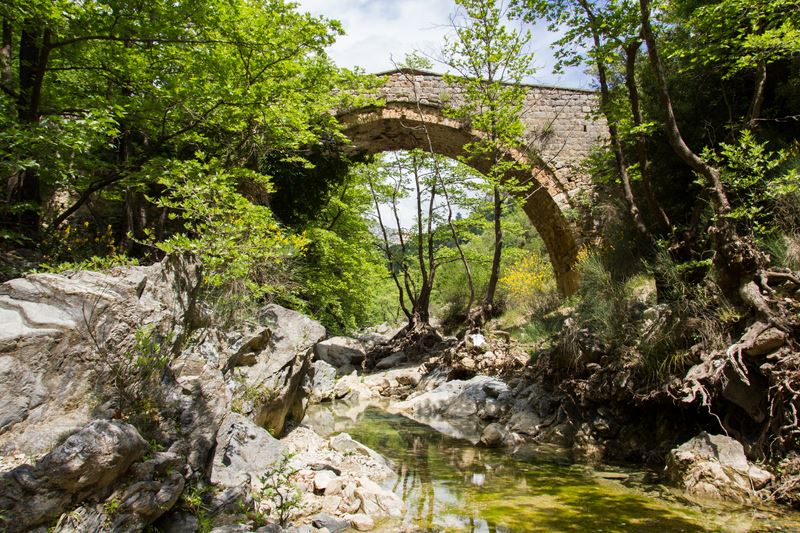
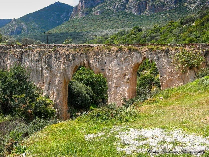
At a distance of 3 km east is the beach of Agios Andreas, which extends to a great length, where the remains of the old mill still stand, which over time is handed over to the power of the sea (See p. 222). The picturesque port marks another rich and beautiful image of the area. Near the coast is a small rocky hill, known as “St. Andrew’s Island”. In this place there are ruins of a cyclopean wall that according to archaeologists belong to the ancient Kynourian city of Anthini. Parts of the outer fortification with towers of the 5th – 4th c. e.g. Later the settlement was moved lower to the sea, where Late Roman ruins and additional fortifications from Byzantine times are preserved. Also of archeological interest is the hill of Heronisios which is located north of the Island (2 km NW). Finds from the early Bronze Age, from the Geometric to the Archaic times, were found here. The plain of Agios Andreas is crossed by the river Vrasiatis, inside the riverbed of which shortly before its estuary, there is an elaborate two-chamber stone bridge (See photo p. 227). The visitor of the area has the opportunity to be found 5 km west of Agios Andreas in the enchanting world of the gorge of Zarbanitsa (See p. 123).
From Wikipedia, the free encyclopedia
Agios Andreas is a settlement in the municipality of North Kynouria, built on the slopes of a hill near the sea, next to a plain overgrown with olive trees. It is located on the road Astros-Leonidio at a distance of 6 km from the first. At this point the gorge of Zarbanitsa ends as the river Brasiatis also crosses, just before its estuary in the Gulf of Thyreatiko. It is the Kefalochori of the area and is inhabited mainly by Tsakones. · At a distance of 3 km is the beach of Agios Andreas with a picturesque harbor. On a hill near the spot one can see the ruins of a cyclopean wall that according to archaeologists belong to the ancient Kynourian city of Anthini. Also nearby is an old stone arched bridge. · At the borders of the community is the model settlement for the expatriates, Arkadiko Chorio, the last settlement before South Kynouria. · The village has a football club called A.M.S. Boiling.
From the “Mount Parnon and Moustos Wetland Management Agency, 2015. Guide for the protected area of Mount Parnon and Moustos Wetland. Nature, Culture, Ecotourism. Astros of Arcadia “.
The Tsakonian dialect is spoken by Leonidio, Pragmatefti, Melana, Tyros, Sapounakeika, Agios Andreas, Prasto, Sitaina, Kastanitsa. Settlements: Sampatiki, Livadi, Vaskina, Paliochora, Agios Panteleimonas (Fouska), Dernikeika The Tsakonian dialect The Tsakonian dialect, the Tsakonian dance, the costume, the customs and traditions of the Tsakonians, are another dynamic of the Parnon area. According to the “Chronicle of Monemvasia “:” And the prefectures and peasants of the threshing floors settled in the rugged places adjacent to it, and at the end the jaconia were named “. The Tsakones, as true descendants of the Dorians, kept their roots intact and the Tsakonian language is still the living expression of the Doric dialect. In the cradle of Tsakonia, today insists on walking and creating in the footsteps of yesterday in a perpetual and uninterrupted breath of Greece.
The special linguistic treasure of our place The Tsakonian dialect has been included in the list of endangered languages of UNESCO and is recognized as a cultural achievement and a unique treasure of culture. The language was preserved genuine and unadulterated in the mouths of ordinary people, peasants, shepherds and farmers. In the wishes, in the greetings, in the curses, in the everyday expressions, in the teasing and the jokes, there is for centuries now the linguistic treasure of the Tsakonians. In this special part of the Greek land called Tsakonia (the cradle of Tsakonia was Prastos, Kastanitsa and Sitaina), in these rugged places, the inhabitants of the area, with few means, not only survived, but left behind a valuable heritage, the Tsakonian tradition, the beautiful language, the unique evocative Tsakonian dance, the Tsakonian songs, the weaving art, their habits, what we call today customs and traditions. All this composes the identity of the place with a living language that is in the hands of the Tsakonians, but also of all Hellenism, to embrace it and protect it from oblivion
“It is estimated that the population of Prastos in medieval times amounted to 9,000 inhabitants. Prastos then had 9 parishes, 30 churches and intense economic activity. “
Agiopetritis, the protagonist and memoirist of the Struggle, Anagnostis Kontakis, writes that:
“if it were not for Prastos, who fed the army for 4 months, the struggle for freedom would have been lost”.
Prastos is approximately 220 km from E. Venizelos Airport, 72 km from Tripoli, 32 km from Astros and 69 km from Sparta.
To get there you will follow the following routes:
· Astros – Agios Andreas- Prastos (approximately 32 km)
· Tripoli – Astros – Prastos (approximately 72 km)
· Sparta – Kastanitsa – Prastos (approximately 69 km)
From our Municipality
Old capital of Tsakonia. Rich Medieval City.
The lost greatness of the mountain village of Tsakonia is reflected in the song “Tell me where your towers are, where your nobility is”. It is located at an altitude of 750 meters, is 20 kilometers from the village of Agios Andreas, with a difficult route that compensates the visitor with its beauty and its special local architecture. The tower houses are typical in the village and are preserved of Sarantari, Kalimeris, Merikas, Karamanos, Gounelos, while there are remains of Byzantine temples such as Taxiarches, Agios Dimitrios and Panagia which was the Diocese. On the road to the village from Agios Andreas the visitor meets the monastery of Artokosta while one can also see the old monastery of Englestouri (building of 1733). The village is adjacent to the mountainous Korakovouni, while nearby is the gorge of Mazia, where one can see watermills and water mills. There is no tourist infrastructure in the village and so the visitor must find accommodation in other villages of Parnonas. Manolis Dounias came from Prastos and led the Fall of Tripoli in 1821. There is a bust of him in the village.
From the “Mount Parnon and Moustos Wetland Management Agency, 2015. Guide for the protected area of Mount Parnon and Moustos Wetland. Nature, Culture, Ecotourism. Astros of Arcadia “.
Built amphitheatrically on the slope of Mount Parnon, at an altitude of 750 m and at a distance of 30 km from Astros and 20 km southwest of Agios Andreas, is the traditional and preserved settlement of Prastos, the historic capital of Tsakonia from the Middle Ages to 1826. It is a beautiful and picturesque village that charms with its traditional houses, tower houses and churches. Its houses retain the main elements of the local architecture, which is simple and characteristic: arched doors, narrow windows, decorative window, built staircase with high arch, slate slabs and often with strong defensive and fortified elements. From medieval times it was a crowded and prosperous city, full of towers, rich mansions and churches. The choice of the steep location, where the village was built, was mainly due to defensive reasons due to the pirates. Most of the Tsakonian population had settled here, where they maintained their main residence. It is estimated that the population of Prastos in medieval times amounted to 9,000 inhabitants. Prastos then had 9 parishes, 30 churches and intense economic activity.
At that time the maritime trade was flourishing while the trade relations of Prastos had reached as far as Constantinople, Russia, Turkey, Egypt and France. The saying “the city produces white and Prastos makes them castles” is typical. The goods were usually transported by ships from Spetses and Hydra, the main shareholders of which were the merchants from Prastia. In 1826 it was set on fire by Ibrahim and since then it was deserted, when the inhabitants of the village in their attempt to escape fled to Leonidio, “the safe place”, according to Th. Kolokotronis. The prosperity and glamor of the village in the past have left their mark strongly on today. Several old tower houses are preserved with the most characteristic features of Sarantari (one of the best preserved, with a built-in inscription of 1722), Kalimeris, Merika, Karamanos (1788) and Gounelos, built in the second period of Ottoman rule. All are fortified houses with rifles. From the numerous and majestic churches of the heyday, are preserved today and stand out: Taxiarches (18th century), Agios Dimitrios (17th century) and Panagia, old metropolis. Below the old metropolis is the small square of the village, which has recently been renovated. Here is the bust of Prastiotis Manolis Dounias, fighter of 1821 and conqueror of Tripolitsa on September 23, 1821. In the nearby gorge of Mazia there are today the remains of dozens of watermills and water mill, which mark the great prosperity of the village in the past. The memories and nostalgia for this rich and historical past of the village Mr. are also recorded in the Tsakonian folk song: “Prastos me, your towers say and your nobility says!”.
Prastos, who during the period of Ottoman rule was a vilayet (administrative district), actively participated in the Orloff Revolution (1769-1770), as well as in the Klefturia movement. Dozens of Friends from Prastos will contribute decisively to the uprising of the Genos but also to the beginning of the Revolution in the area of Kynouria. Led by Theodoros Goulelos and Giorgakis Manolakis or Michalakis, 250 Prastian warriors set out to occupy the fortress of Monemvasia, of great military importance and invincible, as it was considered. At the same time, the Proestos and Demogerdos of Prastos, in consultation with Kolokotronis and the people of Verveni, Karabela and Kritiko, established in Vervena the famous “Cellar”, ie the chamber of the Army, to supply Prastos with food to the army. , in which many Prastian fighters also participated. Agiopetritis, the protagonist and memoirist of the Struggle, Anagnostis Kontakis, writes that: “if it were not for Prastos, who fed the army for 4 months, the struggle for freedom would have been lost”.
The Prastiotes fighters took part in many battles of the Revolution of 1821. Their contribution to the fall of Tripolitsa was decisive, where Manolis Dounias is considered as its conqueror.
Prastos holds many golden pages in the Revolution of 1821 with invaluable contribution and heroic struggles.Dozens of dignitaries and leaders, chiefs, teachers, clergy, sponsors and hundreds of activists, offered the maximum and contributed decisively to the successful outcome of the Struggle for Freedom. From Prastos start paths and picturesque routes that lead to rich and important cultural and natural monuments. In addition to the traditional festivals of the village during the summer, various cultural events and activities are organized and several tributes to the Tsakonian dialect and tradition.
From Wikipedia, the free encyclopedia
Prastos is a traditional mountain village of Arcadia, built amphitheatrically on the slopes of Mount Parnon at an altitude of 649 meters. It is located 20 km from the village of Agios Andreas.
Administratively it belongs to the Municipality of North Kynouria. In medieval and modern times it was the historic capital of Tsakonia. Even today, the Tsakonian dialect is spoken by the oldest History Prastos is mentioned for the first time in a gold bullion of the emperor Andronikos II Palaiologos in 1293 with the name Proastion.
It succeeded the ancient city of Orion, as it became the seat of the Diocese of Reontos Prastos, thus becoming the largest Tsakonochori. He gained great power and wealth during the Second Ottoman Empire (18th & early 19th century). At that time it is estimated that Prastos had a population of over 6,000 people, 30 churches, 9 parishes, 3 monasteries, 2 castles and several mansions – tower houses. People traveled to Spetses, Hydra, Istanbul and other places and acquired large fortunes.
In 1770, during the Orlofiks, Prastos and the whole of Tsakonia actively participated, led by Nektarios, Metropolitan of Reontos-Prastos, the priest Giannakis Goulenos, the teacher Emmanuel Trochanis and many more. With the founding of the Friendly Society, in 1814, the Prastiotes – Tsakon merchants, began to become members, reaching 10, including the Prastiotis merchant George Panou (Captain Giorgakis), the distinguished Giannoulis Karamanos and many people from surrounding villages. Kastanitsiotes Giannis Kapsampelis and the prostitute Nikolaos Palladas. In 1819, Prastos was separated from the Vilaeti of Agios Petros and became the capital of the Vilaeti of Prastos. This vilayet also included Kastanitsa, Sitaina, today’s Agios Andreas, Korakovouni, the area of Tyros, up to Leonidio.
Prastos also offered a lot during the Revolution of 1821. On March 16, the Prastiotes – Tsakones, proclaim the Revolution in Tsakonia. A few days later, the Prastiotes, under the leadership of Goulenos and Manolakis, started with a body of 250 men to the castle of Monemvasia, where it was captured on July 23, 1821. In addition, their contribution to the Fall of Tripoli was important, with a body of 300 men, united with the bodies of Agiopetrites, under Anagnostis Kondakis, Agiannites, under Panos Zafeiropoulos, Verveniotes, Dolianites and many others. On September 23, 1821, Manolis Dounias from Prasti was the first to enter Tripolitsa, which was besieged for a long time. The Prastiotes successfully participated in other battles (eg Battle of Bervena, Battle of Doliana, etc.). In 1826, Ibrahim Pasha completely destroyed the village. areas. In the following years, Prastos became the capital of the Province of Kynouria and the seat of the municipality of Vrasia.
The village Prastos has beautiful mansions, tower houses and churches, characteristic examples of Tsakonian architecture. In the 18th and 19th centuries, the merchants who were rich in Constantinople, Spetses, Hydra and elsewhere, built great mansions – tower houses, which survive to this day, such as Sarantari (1722), Kalimeris, Merika, Goulenos, Karamanou (1788), by Hadjipanagiotis, but also by the German Deffner. Prastos also has old, important churches, such as Panagia (1762), where it was the Diocese, Agios Dimitrios (17th c.), Taxiarches (17th c.), Agios Nikolaos (17th c.), Profitis Elias , Saint Athanasios (16th century) and others. In the past there were more churches that do not survive today, such as Panagia Stoliotissa, Agia Paraskevi, Agios Georgios and Agios Ioannis.
Near the village are Kastanitsa, Sitaina, the Monasteries of Artokostas, Karya and the ruined monasteries of Agios Dimitrios Reontinos and Prodromos (Englestouri). To the east is Mount Korakovouni. In winter, the village is left with few inhabitants, while in summer it is full of people. It has also been declared a traditional settlement
From the GUIDE FOR THE PROTECTED AREA OF MOUNTAINS PARNONA & WET WET ·
The Tsakonian dialect, the Tsakonian dance, the costume, the customs and traditions of the Tsakonians, are another dynamic of the Parnon area. According to the “Chronicle of Monemvasia”: “And the prefectures and peasants of Thremte were settled in the rugged places adjacent to it, and finally the jaconia were named”. The Tsakones, as true descendants of the Dorians, kept their roots intact and the Tsakonian language is still the living expression of the Doric dialect. In the cradle of Tsakonia, today insists on walking and creating in the footsteps of yesterday in a perpetual and uninterrupted breath of Greece. ·
The special linguistic treasure of our place. The Tsakonian dialect has been included in the list of endangered languages of UNESCO and is recognized as a cultural achievement and a unique treasure of culture. of farmers. In the wishes, in the greetings, in the curses, in the everyday expressions, in the teasing and the jokes, there is for centuries now the linguistic treasure of the Tsakonians. In this special part of the Greek land called Tsakonia (the cradle of Tsakonia was Prastos, Kastanitsa and Sitaina), in these rugged places, the inhabitants of the area, with few means, not only survived, but left behind a valuable heritage, the Tsakonian tradition, the beautiful language, the unique evocative Tsakonian dance, the Tsakonian songs, the weaving art, their habits, what we call today customs and traditions. All this composes the identity of the place with a living language that is in the hands of the Tsakonians, but also of all Hellenism, to embrace it and protect it from oblivion.
See the link
The Offer of Prastos in the Revolution of 1821 “
This shortage forced the besieged Turks to trade with the Greek besiegers, in order to save food. This fact was taken advantage of by Prastiotis Manolis Dounias and he gained acquaintances, “friendly” relations with the guards of the wall so that, at the critical moment, he could enter the city and open, together with others, the so-called Nafplio Gate, “to be invaded by the Greek warriors, with the first Tsakones-Prastiotes, who had been properly prepared by their leaders, and to occupy Tripoli together in a few hours.”
Kastanitsa is the first village of Tsakonia and one of the oldest villages of Parnon. We had no problem finding sources for our post, the problem was that we found many good sources. I’m sure there are other better ones than the ones we have below.
We all say our village is the best and the second village is Kastanitsa, the conclusion is easy ….. Someday we all have to visit Kastanitsa and on the chestnut festival even better ..
From our Municipality
The oldest Tsakonochori with the Tsakoniki dialect is still spoken by its inhabitants. The first written appearance of the village takes place in Chrysovoulos of Andronikos in 1293m. X. At an altitude of 840 meters and 152 kilometers from Athens and 72 from Tripoli, it is a historic preserved settlement with special architecture and white houses made of slate slabs from Malevo. The colored windows in houses, many of which are tower houses of more than 300 years and the flowers in gardens and courtyards, give an island color to the village that has been built between two green streams. Its inhabitants fought the Turkish conqueror in 1896 from the Castle of the village, from which the view is excellent. The chestnut forest of the area is of special beauty and recognized as a natural monument. In fact, the chestnut festival attracts many people, while the visitor can walk on beautiful natural routes, enjoy the unique landscape of Parnon and relax from the hustle and bustle of the city. The village has a guest house, small accommodation and a beautiful square with excellent views. While just outside the village is the church of Ag. Nikolaou and Panteleimonos Kontolinas. The church has been saved from the homonymous monastery of the 17th century. destroyed by Ibrahim’s army. Traces of fire can still be seen today, mainly in the dome. From this point begins the impressive gorge of Mazia, one of the many gorges of Parnon.
From the Ethnos
“Kour made the country of Namos” that is “Welcome to our village” “And for history, for the Tsakonians, he first speaks in the 9th century AD. the emperor of Byzantium Constantine the Purple-Born. Around 1000 AD. the Tsakonians left over from the great Slavic invasions began their peaceful work, necessary for their survival. A few years later – in 1293 AD – the first Tsakonochori, Kastanitsa, made its official written appearance. “
Kastanitsa, perched on the slopes of Mount Parnon, at 840 m., Is the oldest Tsakonochori, with a history of more than seven centuries and one of the oldest mountain villages of Kynouria (s.s. belongs to the municipality of North Kynouria). Characterized since 1967 by the Ministry of Culture by Presidential Decree, a traditional – preserved settlement with special natural and architectural beauty, built on a narrow hill, stands out with its tower houses, painted white, with roofs of local slate Malevos and wood with bright colors on the doors and windows and flowered courtyards.
And why whites, in a mountainous settlement, in the heart of Parnona Because, once upon a time, Kastanitsa was famous for its production of lime, from where it got its color, and in which there were more than 30 traditional lime kilns for roasting lime.
The village retains unchanged elements of the Tsakonian tradition, while some elderly people from 30 – 40 permanent residents speak the Tsakonian dialect.
• How to get there: From Athens follow the route to Corinth, Tripoli, exit to Nafplio, Argos, Astros and from there either from Agios Andreas or from the villages of Platanos and Sitaina. You will travel 205 km. From Astros, Kastanitsa is 31 km, from Tripoli 71 km and from Sparta 65 km. From Thessaloniki calculate the 500 km to Athens and then the 205 km to your final destination.
• Accommodation / Food: In Kastanitsa operates the traditional guesthouse “Antoniou” which has 5 rooms. The tavern “To Stolidi” also operates in the hostel (tel. 27550 52255). For food, there are two other taverns, “O Parnon” in the square, “O Liakouris”, and a cafe. Other accommodation options are in Platanos (20 km), Polydroso in Laconia (11 km), Agios Petros (11.5 km), Astros (31 km), Parnonas shelter above the village of Vamvakou ( EOS Sparta) etc.
From the “Mount Parnon and Moustos Wetland Management Agency, 2015. Guide for the protected area of Mount Parnon and Moustos Wetland. Nature, Culture, Ecotourism. Astros of Arcadia “.
Kastanitsa Kastanitsa, a traditional and preserved settlement since 1967 with special natural and architectural beauty, built in the heart of Parnon at an altitude of 840 m. And at a distance of 31 km southwest of Astros. It used to be famous for its production of lime, from where it got its color, as well as for the chestnuts that gave it its name. The large chestnut forest that surrounds it has an area of 4,500 acres. It is one of the p older existing mountain villages of Kynouria and the oldest village of Parnonas. The first written report of the village is found in 1293 in a golden decree of the Byzantine emperor Andronikos II Palaiologos, in which Kastanitsa is listed as “Komi the so-called Constanta”. Since then and in the following centuries, according to written historical sources, its historical course has never been interrupted. Kastanitsa is built on a passage of strategic importance. During the 14th century a castle was built on the top of the hill above the settlement by Byzantines of the Despotate of Mystras, whose ruins are preserved to this day. The village actively participated in the revolution of 1821 with several chiefs and hundreds of ordinary freedom fighters. The people of Kastanitsa strongly resisted Ibrahim’s troops who invaded the area on July 27, 1826, on the day of St. Panteleimon, saving the village from destruction. In the subsequent struggles, Kastanitsa was present, culminating in the National Resistance 1941-44.
DCIM\100MEDIA\DJI_0076.JPG
The village preserves the traditional Tsakonian architecture with its characteristics, painted white, tower houses with local slate roofs, wooden balconies, bright colors in the windows and the flowered courtyards. The view from the hill – the Kapsampelis Tower (See p. 216) – at the top of the settlement, as well as from the renovated square, is excellent. It is surrounded by a dense and unspoiled forest of firs and chestnuts and is an ideal place for tranquility and walking tourism. In the center of the village dominates the patron church of the Transfiguration of the Savior, built around 1780. In 1810 and with the money of the late Kastanitsiotis Elias Manesi, an official of Catherine the Great but also by the founding members of the Friendly Society from 1818, it was built in Odessa and transferred to Kastanitsa the ornate wooden iconostasis of Russian style. dominates the center of the village. Along with the iconostasis at the same time were donated both large gilded manuals, which are still preserved in very good condition. Around the village there are 15 chapels excellently preserved, with the oldest being that of Agios Panteleimon. The folk festivals, which for centuries stood as points of reference and social and cultural creation of the ancestors, are preserved today with the most important one being the Transfiguration of the Savior on the 5th and 6th of August. An important annual cultural event is the “Forest Festival” during the first fortnight of August, and the “Chestnut Festival” which is organized every year on the last weekend of October (See page 274). The village has a very active Educational & Nature Association with many important activities and young children at the forefront. Important and with special characteristics are also the paths that connect Kastanitsa with the nearby settlements of Prastos, Sitaina and Platanos, but also the unique routes in the gorges of Mazia and Koutoupou-Zarbanitsa as well as the path that leads to Megali Tourla. A few kilometers outside of Kastanitsa is the Monastery of Kontolina (See p. 189).
The Tsakonian dialect is spoken by Leonidio, Pragmatefti, Melana, Tyros, Sapounakeika, Agios Andreas, Prasto, Sitaina, Kastanitsa. Settlements: Sampatiki, Livadi, Vaskina, Paliochora, Agios Panteleimonas (Fouska), Dernikeika
The Tsakonian dialect
The Tsakonian dialect, the Tsakonian dance, the costume, the customs and traditions of the Tsakonians, are another dynamic of the Parnon area. According to the “Chronicle of Monemvasia”: “And the prefectures and peasants of Thremte were settled in the rugged places adjacent to it, and finally the jaconia were named”. The Tsakones, as true descendants of the Dorians, kept their roots intact and the Tsakonian language is still the living expression of the Doric dialect. In the cradle of Tsakonia, today insists on walking and creating in the footsteps of yesterday in a perpetual and uninterrupted breath of Greece.
The special linguistic treasure of our place The Tsakonian dialect has been included in the list of endangered languages of UNESCO and is recognized as a cultural achievement and a unique treasure of culture. The language was preserved genuine and unadulterated in the mouths of ordinary people, peasants, shepherds and farmers. In the wishes, in the greetings, in the curses, in the everyday expressions, in the teasing and the jokes, there is for centuries now the linguistic treasure of the Tsakonians. In this special part of the Greek land called Tsakonia (the cradle of Tsakonia was Prastos, Kastanitsa and Sitaina), in these rugged places, the inhabitants of the area, with few means, not only survived, but left behind a valuable heritage, the Tsakonian tradition, the beautiful language, the unique evocative Tsakonian dance, the Tsakonian trago yds, the weaving art, their habits, what we now call manners and customs. All this composes the identity of the place with a living language that is in the hands of the Tsakonians, but also of all Hellenism, to embrace it and protect it from oblivion
From Clikatlife
Lime, chestnuts and celebration ·
For centuries, Kastanitsa was famous for its production of lime, which was baked in traditional kilns (once there were over 30 lime kilns in the village), while today, the houses, courtyards, churches and walls of Kastanitsa, continue to be whitewashed and white, like on an Aegean island. · The village is also famous for the chestnuts, which probably gave it its name. The large chestnut forest that surrounds it has an area of 4,500 acres and in the past, the chestnut harvest exceeded 400 tons. ·.
From Wikipedia, the free encyclopedia
Agios Nikolaos-Panteleimon Kontolina Kastanitsa The monastery is located in a lush forest area, between chestnut trees and firs, 12 km from the settlement of Kastantitsa to Stravotrachi. Today the repaired katholikon is preserved and frescoes of the 18th century are preserved. of Kyriakos Koulidas and the nephew of “Panos” (1760 AD). The monastery was originally named Agios Nikolaos and according to tradition took its current name, from the victorious battle against Ibrahim (eve and day of Agios Panteleimon on 26 – 27 July 1826 AD), as the inhabitants of the area attributed part of the victory to the help of Saint Panteleimon. The monastery according to a patriarchal sigil of 1628 AD. was built at the beginning of the 15th c. and operated between 1628 and 1834 AD. when it is dissolved after the decree of Otto. In 1826 he was destroyed by Ibrahim’s hordes in retaliation for the defeat of his army in the area of Kastanitsa. The all-wood carved iconostasis is preserved in its original form, with floral decoration. It is celebrated on the feast of St. Panteleimon, on July 27. When you open the links you see our sources. Sources, photos and texts <, Clicatlife Nation, newsbeast.driverstories>
Please see the links, they are very excellent like Kastanitsa …..
From the “Mount Parnon and Moustos Wetland Management Agency, 2015. Guide for the protected area of Mount Parnon and Moustos Wetland. Nature, Culture, Ecotourism. Astros of Arcadia “.
Sitaina The fir-covered Sitaina, Tsakonochori, at a distance of 23 km southwest of Astros and at an altitude of 740 m., Is built left and right of a beautiful – green ravine and below the imposing peaks of Parnon. Its traditional stone houses have the characteristics of Tsakonian architecture. The first written mention of the village is made in a chronicle of the well-known historian Georgios Frantzis, in the year 1435.
During the period of Kleftouria, Dimitrios Kaliotzis, Sitainiotis, is among the seven most famous Thieves of the Peloponnese, will be the terror of the Turks and his rich action will be praised by the popular Muse in many folk songs. The participation of the people of Sitaini in the national uprising of 1821 is impressive. In Sitaina, two military corps will be created, with more than 100 fighters and led by Georgios L. Bourmas and Theodoros Ioannou or Kritikos. With the beginning of the Revolution, Th. Ioannou will leave Nafplio, where he lived with two privately owned ships and the coal monopoly. In Sitaina he will organize and arm at his own expense, having sold his two ships, more than 80 Sitaini, under whose leadership they fought in all the battles of the Peloponnese. In the Byzantine castle of Zagoli, 3 km northeast of the village, late July-early August 1826, the fortified inhabitants and fighters of Sitina will successfully repel and humiliate the hordes of Ibrahim. In 1835, with a royal decree, the Municipality of Sitaini was created. The three impressive and intricately shaped cobbled squares of the village, the vaulted rich fountains and the crystal clear waters of many rich springs, the churches of Taxiarches and Agios Ioannis the Theologian with the strong Byzantine characteristics, the watermill and the rich , in combination with the rich and varied natural environment, create unique images of enchanting beauty, which win the visitor. The fir forest of Sitaina is a unique natural monument. Impressive plateaus, such as those of Profitis Ilias-Kambos, Loutsa and Kambos, rich and complex flora, a multifaceted world of trails, with strong traces and signs of intense human activity in the past marked by lime kilns and marbles , the wells. In the wider area of the village there are also interesting caves, which were a refuge of the inhabitants, both during the Turkish occupation and during the German occupation (Karatza, Kaliotzi, Karahaliou). Sitaina, thanks to its rich natural environment and the numerous paths, many of which follow the ancient road network of the area, is today a pole of attraction for groups of hikers and mountaineering clubs, for the needs of which a free camping area has been formed near the square. Theologos, from the cultural association of the village. Among the many and interesting paths that open and unfold from the village, those to the gorge and the waterfall of Louluga-castle Zagolis and to the plateau Profitis Ilias-peaks of Tourlas are routes known in Greece and with the greatest walking traffic. From the other routes, the old path-mule road that leads to Platanos, the route to the forest of Leka, the path to the bridge and the gorge of Koutoupou stand out. Sitaina is also an ideal starting point for exploring the wonderful world of Brasiatis Gorges. The poet Theodoros Papagiorgopoulos (1862-1941) was born and lived in Sitaina for many years, and he wrote articles in various newspapers and magazines in Athens under the pseudonyms “Sfouggis” and “Parnis”. Sitaina was also the birthplace of the monk Joseph Karatza, founder of the Holy Monastery of Malevi (1916). In addition to the religious festivals, the Cultural Association of the village organizes every summer rich cultural events and activities, such as the Meeting of the Sitainiotes, Youth Festivals, the Gorge Festival, the Bread Circle.
From ExploringGreece
Sitaina together with Kastanista and Prastos formed the original core of Tsakonia. Very picturesque village among the firs, offers multiple possibilities for excursions in the nature of Parnon. The village has traditional stone houses and a lot of water
From Wikipedia, the free encyclopedia
Sitaina is a mountain village in the prefecture of Arcadia, built amphitheatrically on the slopes of Mount Parnon at an altitude of 700 m., Near its highest peak, Megali Tourla (1934 m.). The village is located 30 km from Astros .
Sitaina is administratively part of the Municipality of North Kynouria. Sitaina is a Tsakonochori in which, along with the nearby villages of Prastos and Kastanitsa, the Tsakoniki dialect is still spoken by the elders.
History
Sitaina is mentioned for the first time in the Chronicle of the Fall of Georgios Sfrantzis, under the name Sitana. The name “Sitaina” is Slavic [3] and means swamp, swamp. In the following years, it is mentioned in various documents of the Turkish occupation and the Venetian occupation. During the pre-revolutionary years, the well-known thief and captain of Captain Zacharias, Dimitrios Kaliontzis, was born in Sitaina. The contribution of the village was also important during the Revolution of 1821, as 150 Sitainiotes joined various corps, with great success. In 1826 Ibrahim Pasha completely destroyed the village, as well as all the other villages of Kynouria. According to tradition, the villagers took refuge in the cave of Zaggoli. In the following years Sitaina became the seat of the Sitaini Community.
The village
The village is full of firs and various trees, while, like the other Tsakonochoria, it has many mansions – tower houses, samples of Tsakonian architecture. Sitaina has two churches: Taxiarches and Agios Ioannis Theologos. Near the top of Parnon, there is the church of Profitis Ilias.
Near the village there is the fortified church of Panagia Zaggoli, mentioned by the traveler William Martin Lake in 1805. The inhabitants of Sitaina took refuge in this cave, after its destruction by Ibrahim. Nearby are the gorges of Loulouga, Koutoupou, Zarbanitsa and Mazia, where hiking and mountaineering takes place. Near Sitaina are the villages of Prastos, Kastanitsa, Arcadia, Platanos, Arcadia, etc.
From the “Mount Parnon and Moustos Wetland Management Agency, 2015. Guide for the protected area of Mount Parnon and Moustos Wetland. Nature, Culture, Ecotourism. Astros of Arcadia “.
The Tsakonian dialect is spoken by Leonidio, Pragmatefti, Melana, Tyros, Sapounakeika, Agios Andreas, Prasto, Sitaina, Kastanitsa. Settlements: Sampatiki, Livadi, Vaskina, Paliochora, Agios Panteleimonas (Fouska), Dernikeika
The Tsakonian dialect
The Tsakonian dialect, the Tsakonian dance, the costume, the customs and traditions of the Tsakonians, are another dynamic of the Parnon area. According to the “Chronicle of Monemvasia”: “And the prefectures and peasants of Thremte were settled in the rugged places adjacent to it, and finally the jaconia were named”. The Tsakones, as true descendants of the Dorians, kept their roots intact and the Tsakonian language is still the living expression of the Doric dialect. In the cradle of Tsakonia, today insists on walking and creating in the footsteps of yesterday in a perpetual and uninterrupted breath of Greece.
The special linguistic treasure of our place The Tsakonian dialect has been included in the list of endangered languages of UNESCO and is recognized as a cultural achievement and a unique treasure of culture. The language was preserved genuine and unadulterated in the mouths of ordinary people, peasants, shepherds and farmers. In wishes, in greetings, in curses, in everyday expressions, in teasing and jokes, there is for centuries now the linguistic treasure of the Tsakonians. In this special part of the Greek land called Tsakonia (the birthplace of Tsakonia was Prastos, Kastanitsa and Sitaina), in these rugged places, the inhabitants of the area, with few means, not only survived, but left behind a valuable heritage, the Tsakonian tradition, the beautiful language, the unique evocative Tsakonian dance, the Tsakonian songs, the weaving art, their habits, what we call today customs and traditions. All this composes the identity of the place with a living language that is in the hands of the Tsakonians, but also of all Hellenism, to embrace it and protect it from oblivion
From our Municipality A picturesque village built on the southeast side of Parnonas at an altitude of 450 meters, is 180 kilometers from Athens. The settlement has been characterized as a preserved traditional and the visitor is enchanted at first sight by the rich vegetation and the many waters that he faces when he reaches the village.
The village is known for its microclimate and its water. “Like Platanos, you will not find water anywhere else. With one sip you do not want a doctor, with two you find a match “. The old watermill, the stone fountain, the imposing church, the alleys, the Fire of Fate that meets whoever arrives in the village offer images that relax and calm the mind and soul. Those looking for adventure and direct contact with nature can find it by exploring the Cave Canyon.
In the area there is the Cave of Sotiros or Sosimos, you can also go hiking in the gorge of Lepida. The fauna of the area is also rich, while the feasts of love, water and moons in August with the filling of the Moon and the feasts of cherries in May are special and well-known. Nearby the villages of Haradros and Sitaina with rich vegetation and incomparable natural beauty.
From the “Mount Parnon and Moustos Wetland Management Agency, 2015. Guide for the protected area of Mount Parnon and Moustos Wetland. Nature, Culture, Ecotourism. Astros of Arcadia “.
Platanos is known for its climate and its water. The marble inscription on the fountain in the central square “warns”: Like Platanos you will not find water in other places with one sip you do not want a doctor with two you find a match. Platanos is 20 km from Astros and is built amphitheatrically, at an altitude of 450 m. On the northeast side of Mount Parnon, at the base of a green ravine. It is surrounded by beautiful and unspoiled natural environment full of chestnuts, pines, plane trees and firs. Platanos is a picturesque village full of narrow cobbled streets, stone houses, plenty of water, but also many fruit trees, such as cherries, pears, walnuts. His houses retain the main elements of the local architecture, which is combined with island elements.
At the entrance of the village is the central cobbled square with the first waterfall of the village “Chares” and impressive rich vegetation. The central church of the village is Agia Anna, while there are two more post-Byzantine churches, Agios Georgios and Agios Theodoros with elaborate hagiographies. Also of interest is the Tower of Squadron with a defensive corner construction (18th century), which is a typical tower house. Opposite the village, an emblematic rock with the name “Kalogeros”, due to its shape, provides a wonderful view to the village, but also to Parnonas.
Southeast of the village, near the bridge begins the idyllic gorge of Spilakia (See p. 121) with dense vegetation and abundant water that ends in the river Vrasiatis. Another path, shortly after the bridge, leads to the chapel of Agiorgis. In the area of the gorge there is the Cave of the Savior or Sosimos, which during the years of the Revolution became a refuge for the inhabitants of the village due to the rage of Ibrahim’s soldiers. The visitor can also enjoy the nature of the area by hiking in the gorge of Lepida (See p. 119). Another path, between the terraces where the Platanites cultivate their orchards, leads to the Monastery of the Assumption of the Virgin or Sela, as it is known, in an area of exceptional beauty. The ornate frescoes of the Monastery represent martyrdoms, with direct references to the period of Ottoman rule.
The permanent residents of Platanos are few, but in summer the village comes to life. Rich cultural events are organized throughout the year, such as the famous “Feast of Cherries, Waters and Love” (See p. 282), the “Feast of Chestnuts and Figs”, the original “Backgammon Meeting” tournament, the “Full Moons” And many others.
Watermills and Water Mill :.
In the central square of Platanos is the Barkaikos watermill and next to it the two-story traditional stone fountain. It is the only mill of the four that the village used to have, with an internal mechanism that still works by grinding wheat and corn serving local needs, while at the same time it is a museum space for the visitors of the village. Next to and just below the Barakaikos watermill is the Perraean water mill or dristella (See p. 219). Before the ravine there is the Latsaikos watermill which is covered by large centuries-old plane trees.
Nymphs Waterfall & single-arched bridge: Descending to the ravine, the well-maintained path leads to the Nymphs Waterfall. The waterfall is about 10 m high and is surrounded by lush vegetation and imposing plane trees. The spot is especially popular with nature lovers especially in summer. Crossing on the path, parallel to the river, we meet the old single-arched bridge (See p. 354)
The stone bridge of Platanos:
The single-arched stone bridge of Platanos is a part of the history and tradition of the village. Nowadays its usability has been limited, however its beauty abounds. Built at the beginning of the 19th century, it served the daily needs of the inhabitants, as it connected Platanos with the coastal Kynouria. The conductors and shepherds of Platanos transported their wares and herds using this bridge, especially in winter, as the only passage to Eastern Kynouria and Argolida. In addition, residents of neighboring villages (Agios Ioannis, Orini Meligous, Haradros, etc.) easily transported their cereals to the watermills of Platanos located near the bridge. Today, the need to maintain and enhance the stone bridge – which is an integral part of Platanos’s physiognomy and is of particular cultural interest – is imperative, as the rapid water volumes collected by Lepida (Lepida waterfall) and the surrounding torrents, which in They end up in the river Vrasiatis, they may possibly threaten this beautiful monument of the village in the future.
From Wikipedia, the free encyclopedia
Platanos is a village, which is located amphitheatrically built on the slopes of Mount Parnonas. Administratively it belongs to the Municipality of North Kynouria in the Prefecture of Arcadia. It has a distance of 180 km from Athens and 22 km from Paralio Astros. It is surrounded by many plane trees of hundreds of years, hence the name of the village. It has the form of an island with alleys where no cars can enter. The inhabitants claim that their origin is from an island, probably Aegina. It has been declared a traditional settlement. Next to the village flows the river Vrasiatis. Due to the river, many public fountains and ditches in the alleys have been created in the village. It borders the village of Haradros, Agios Ioannis and the Tsakonian village of Sitaina. At a distance of 2 km from the village is the gorge of Lepida
History
Platanos is mentioned for the first time in the Chronicle of the Fall of Georgios Sfrantzis in 1435, with the name Platamonas. In the following years, he refers to several documents during the Venetian period. Before and during the Second Ottoman Empire (18th and 19th century) the village flourished, along with other neighboring villages. At the same time, several mansions and tower houses were built. The contribution of the village was important during the Revolution of 1821. In 1826, Ibrahim passed through the village but the inhabitants were saved because they hid in a cave on the opposite hill which the inhabitants still call “troupa”. There is an oven and a cistern inside.
After the liberation, it became the seat of the municipality of Platanountos, while in the following years, after its merger with the Municipality of Thyreas, it became the seat of the homonymous community.
The village
In Platanos, due to its abundant waters, watermills, water saws and water mills used to operate. The inhabitants are mainly engaged in the cultivation of agricultural products, such as cherries, chestnuts, figs, but also tomatoes and various squash. The ancients remember the fields full of lanterns at night where the inhabitants went and watered them. Also, half of the population of the village was once engaged in animal husbandry. Now there are 3-4 families. The traditional musical instruments of the village are the lute and the violin. The organ players were invited to festivals and weddings in the neighboring villages.
In the village there are 5 churches: Agios Georgios, which is located on the opposite hill and is considered the first church of the village. According to tradition, the first settlement was located there, Agioi Theodoroi, located at the top of the village. Beyond Panagia, located on the second hill to the right of the village, surrounded by water and terraces of residents plowing. The area there is called Sela and used to be a monastery which was built at the end of the 15th century. and was hagiographed by Georgios Koulidas. According to tradition, the church took its name from a Turkish aga, who placed a golden saddle in order to save his child from an illness, which was eventually saved. In the church lived monks who were hanged by the Turks. A fountain and concrete benches have been created in the area of the chapel. There, on Easter Tuesday, there was a celebration with organ players.
The church of the Transfiguration of the Savior is located at the top of the village and is open every year on August 6. And this church was formerly a monastery (18th century) where monks had cells. Finally, the church of Agios Petros, located next to the community office of the President of the village. The central church of the village is Agia Anna, whose sleep is celebrated on July 25, with an image procession in the alleys of the village. The church has a half-burned icon from the raid of Ibrahim. In the old days, in the neighborhood
The market of the village called Karakala was concentrated, with a barber shop, a grocery store and two wine shops.
The hostel has been operating in the village since 2010 with coffee and food. There are 2 more cafes. The visitors are mainly climbers and nature lovers, who hike in the gorge of Lepida, on the bridge that leads to the old road to Astros called Skala and served the people before the road network. They are still hiking on the old Platanos-Sitaina path.
See the links below, for texts and photos <our sources>
“Climbed to the closing of a small green ravine of Parnonas. Platanos Kynourias is exactly what you are looking for for an excursion out of the ordinary“
From the “Mount Parnon and Moustos Wetland Management Agency, 2015. Guide for the protected area of Mount Parnon and Moustos Wetland. Nature, Culture, Ecotourism. Astros of Arcadia “.
“Meligou is a neighboring village of Astros, the seat of the Municipality of North Kynouria. Inside the settlement the visitor will observe the bust of Kolokotronis, who had encamped here with the military during the Second National Assembly of the Greeks and will admire the churches of Timios Prodromos and Agios Nikolaos, the squares and the park- recreation area and stadium next to the primary school. Of interest are the stone-built water bridges next to the village and especially the imposing water bridge (Mylovageno) in the area of Agios Georgios. Impressive view from Kastraki Meligous (See p. 215) to the plain of Thyrea, the wetland of Moustos and the Argolic Gulf. The church of Agia Anastasia, with architectural members from antiquity, is located in an area which may hide and mark the ancient city of Thyrea, which according to the written reports of Thucydides “is ten steps away”. Two km south of Meligos is the lagoon of Moustos (See p. 31), an important pole of attraction for visitors, the waters of which end through a complex of artificial and natural canals in the Argolic Gulf, with their impressive estuary and the bridge of Kazarba (See . photo p. 228). From the Bavarian bridge of Casarba to Portes stretches a unique beach, in an idyllic environment that remains unchanged, since it is located in the Area of Absolute Protection of the wetland Moustos.
At a distance of 12 km southwest of Astros and at an altitude of 616 m. Is built the mountainous Meligou. The stone houses of the village and the churches of Agios Georgios and Panagia are impressive. A reference point for the visitor is the beautiful square of Panagia with the imposing age-old plane trees and the rich waters. Northwest of the village of Meligou and a short distance from it, in Spathokommeno, is an ancient prison. The historic Monastery of the Holy Trinity is another dynamic attraction of Meligou. Numerous cultural events and rich festivals are organized by the Cultural and Sports Associations of the village throughout the year. «
The enchanting Portes beach is located in Kato Meligou, is a reference point for all locals and “belongs” to all όλους .. Paralio Astros, Astros and Meligou. The Astrinos agree with the visitors who report that they enjoyed their baths “in Portes, the best beach of Astros”.
Mountainous Meligou Arcadia
From Wikipedia, the free encyclopedia “
The mountainous Meligou of Arcadia, is a mountainous, traditional settlement [of Kynouria. It is built at an altitude of 616 m., At a distance of 12 km west of Astros and next to the village of Agios Ioannis. Administratively it belongs to the Municipality of North Kynouria
History
Orini Meligou is mentioned for the first time in the Chronicle of Moreos by Georgios Sfrantzis in the year 1435 with the name Meligou. The name “Meligou” is of Slavic origin and comes from the tribe of Milingos (or Melingos), who together with the Ezerites settled in the 9th century. in Parnonas, leaving many place names. In the 17th and 18th c. Meligou developed and became one of the richest and most powerful villages in the area along with Agios Ioannis, Agios Petros, Platanos and others. Meligou’s contribution to the Revolution of 1821 was important, as many Meligiotes took part in various battles such as the Bervens, the Dolians, the Tripolitsakas. In 1826, Orini Meligou was completely destroyed by the armies of Ibrahim Pasha, while other villages in the area had the same fate. After the liberation, Meligou became part of the Municipality of Thyreas (based in Agios Ioannis and Astros), while its inhabitants settled permanently in Meliggiotika Kalivia (today’s Winter of Meligou, Arcadia).
The village
Orini Meligou, is built on the slope of a lush and green mountain. The village is full of traditional mansions, fountains, taverns and churches. In the village, there is the church of Agios Georgios with the cemetery and Panagia, which celebrates on September 8. Nearby from the village, there are the chapels of Agios Savvas, Profitis Ilias and Agia Triada, a former monastery built in the 17th century. To the north of the village are the remains of an ancient outpost, at Spathokommeno. In the village take place every year events and festivals, with the most important of the Virgin Mary (September 7-8) and the Holy Trinity. In winter the village is left with few inhabitants, since most of the inhabitants go down to Meligou “
Wall – Greek
Nearby opposite Ano Meligou is the Wall – El At a distance of about 5 km from Astros at the top of the hill above the bends “kodeles” at a short distance from the uphill road to Agiannis is the Greek Wall, from there the view of Thyratida Gis and the Argolic gulf is excellent . At the point there is an inscription of the archeological service that leads to a rural road and after 2 kilometers the visitor reaches a plateau, which is the beginning of a 15 minute walk that leads to the top of a hill, the Wall or Elliniko. Here one can see the ruins of the ancient sanctuary of the god Apollo, ruins of walls, buildings and underground tanks and relics of the Upper Thyrea or for some others of the Nereid.
Holy Triada
“On the road from Astros to Orini Meligou, just before we reach the inn of Kopanitsa, we follow on the left the dirt road and the signs to the Monastery of the Holy Trinity (1612). The monastery is in ruins, but its katholikon is preserved in very good condition
From FBMeligios Symposium
About Meligou
MELIGIOTIS SYMPOSIUM · MONDAY, FEBRUARY 4, 2019 ·
Meligou as we should know is a Village of Kynouria, a Community of the former Municipality of Thyrea and now an Apartment of the Municipality of North Kynouria. The most similar of Meligos are its two parts “in one body and one heart”, the Upper Meligou (Spring house, or Mountainous Meligou, or the “Village”) and the Lower Meligou (Winter house, or Pedini Meligou, or the ” Gialos “, or” Kalivia Meligous “). It is inhabited by the Meligiotes or Meligites, and in addition to Gialos have settled many xenohorites from the mountains of Kynouria (Platanites and Verveniotes mainly, but not only) assimilated. The closest, to a misunderstanding, village in Meligou is Agiannis or Astros, which is the seat of the Municipality of North Kynouria. Some additional information about our village:
1.HISTORY
Our village “Meligou”, as it is officially called today, owes its name – experts say – to the Meligos or Miligos Slavs, who during the middle ages (6th-7th etc. centuries), settled at the foot of the mountains “Parnos” or “Malevos” (as we call it) and “Taygetos” and especially for us in today’s “Orini Meligou” and in fact in the places “Koutri” and “Meliggaria” where there are obvious traces of old settlements and locations with Slavic names.
The descent of the Slavs in the Peloponnese during the Middle Ages, their attitude towards the empire and the Franks and the eventual assimilation with the Greekness of the area and the majority of the population is a great chapter of continuous study for historians and archaeologists.
The “Chronicle of Moreos”, an unknown text of the 14th century, gives information about the Slavs of the Peloponnese, including the Milingos or Meligos (drougos or drogos of Miligos or Meligoi which consisted of Slavic and Greek or ambiguous villages).
Furthermore, Meligou (ie the primitive settlement in the mountainous part) is also known in the year 1435 AD, where it is mentioned by George Frantzis as “Meligon” along with other neighboring villages that still exist today.
During the period (1683-1699), when the Venetian-Turkish dispute over the sovereignty in the Peloponnese was raging, and specifically in 1687, our village is mentioned again in code number 61 of the Monastery of Iveron on Mount Athos by Theophylaktos Agorastos who notes that ” Meimet Pasha came and not wanting the villages to worship him, they enslaved and burned Agios Ioannis, in Melingou, Kastanitsa, etc.
” In the year 1700, during the Venetian occupation, Meligou is mentioned in the census of Grimani as a village in the region of Agios Petros with 43 families (about 160 inhabitants).
During the 18th and 19th centuries our village is mentioned by European visitors, travelers or even spies of that time.
2. ADMINISTRATION
During the second Turkish occupation and the Revolution until 1833, Meligou was administratively part of the Province of Agios Petros. In 1833-1834 Meligou was included in the Province of Kynouria as a Community of the Municipality of Thyrea. With the abolition of the old Municipalities in 1914, Meligou was named as Community of Meligou with a single geographical area, the Mountainous and Winter Meligou. With the introduction of the “Kapodistrias” and “Kallikratis” systems, Meligou is today a Community Department of the Municipality of North Kynouria.
The administrative affiliation of Meligos is in the Province of Kynouria in the Prefecture of Arcadia in the Peloponnese Region
Judicially, Meligou belongs to the Court of First Instance and the Court of Appeal of Nafplio. Meligou as a whole occupies about 25,000 acres of open space and its population is about 900 inhabitants.
3. IDENTITY
During the second Turkish occupation, the Meligiotes, who owned land in the so-called field of Astros, built makeshift houses on the edge of the plain, where they remained for a while, as long as it was necessary for the cultivation of the estates. Over time these buildings became ground floor houses and were named “Kalivia Meligous” or “Meleggitika or Melig iotika Kalivia ”and were the winter residence of the inhabitants. The huts became normal houses, two-storey, the people got rid of the fear of various dangers from the sea and the plague of malaria of the swamp of lake “Moustos” and we arrived today where the main residence of the people of Meligioti is in Pedini or Winter or Kato Meligou or in “Gialos”, while Orini or Apano Meligou or “Chorio”, is a place of recreation and festivals at every opportunity.
“Chorio” is located at an altitude of about 600 meters and “Gialos” about 50 meters above sea level.
“SOUGELOS – WATER MILL – MOTHER OF WATER
These monuments in Kato Meligou were once monumental works for the survival of the inhabitants of the Village. They were built before the liberation by the Turks and the water followed the course from the spring (Mana) with an open aqueduct (Sougelos from the Turkish homonymous su yollari), passed through the imposing Mill Mill of the Watermill to the chapel of Agiorgis, by two stone bridges of the two torrents of Meligos (one survives), from intermediate reservoirs and ended in three public fountains in the village for water supply and in earthen ditches for irrigation. The oldest written reference that has been found so far for these monuments is the notarial contractor of the year 1837 with which the Special Assistant Meligous commissioned the repair of the Mother of Water and Sougelos to a carpenter (“mason”) from Kastri. The course from Meligou along Sougelos to Mylovagenos and from there to Mana tou Nero is for every visitor a true course of history in the natural environment, which is worth experiencing. “
“Mana tou Nerou” is also the name of the spring above the monastery of Loukous, from which Astros and Kato Doliana were supplied with water by Karytsiotis. Two hundred years ago, Karytsiotis donated the school to us and brought us water in the village to pay for the school’s teachers from the farm.”
We bravely borrowed photos and texts from our friends Meligiotes
From the “Mount Parnon and Moustos Wetland Management Agency, 2015. Guide for the protected area of Mount Parnon and Moustos Wetland. Nature, Culture, Ecotourism. Astros of Arcadia “.
Haradros is a beautiful semi-mountainous village, 17 km southwest of Astros, on the northeastern slopes of Mount Parnon, built at an altitude of 568 m. Large and small hills, varied ridges, slopes with olive trees, streams and gorges compose the landscape.
The Haradros land becomes more beautiful with the color compositions and contrasts it acquires in the seasons. Remarkable archeological sites are observed on the borders of the village, such as the Cave of Asoulas (Ai Giorgis) (See p. 126), with timeless habitation from the Neolithic period to the Byzantine times, and the ancient prison at Elliniko, just before entrance to the village, which is preserved in very good condition. The few inhabitants of the village today are engaged in the cultivation of olives and livestock. The oldest church of Haradros is the Prophet Elias, which according to tradition has been built on the ruins of an older church. He is the patron saint of the village and celebrates on the 20th of July. In the village stand out the renovated school (1927) and the fountain Variko (1937) with its two very tall plane trees. At a distance of 2 km southeast of Haradros are Agioi Asomatoi, a small settlement that was once the winter home for the inhabitants of Vourvourou.
From Wikipedia, the free encyclopedia
Haradros (or Trestena until 1927 [3]) is a small semi-mountainous village in the prefecture of Arcadia, built at an altitude of 535 meters on the northeastern slopes of Mount Parnon. It is surrounded by mountains and overlooks a small plain. Slopes with olive trees, streams and gorges compose the landscape of the area.
It is located in the province of Kynouria and is 18 km from Astros. Sights of the village are the school building built in 1927 and the Variko fountain of 1937, which is shaded by two tall plane trees. An olive mill operated in the settlement until 1999
The Municipality of North Kynouria, based in the historic Astros, consists of 26 Local Apartments and 40 settlements, located in the northeastern part of the Prefecture of Arcadia and to the east is bathed by the waters of the Argolic Gulf.
In the whole of Thyrea it is not an exaggeration to say that if you pick up a small stone you will find a historical monument and an archeological treasure.
Agios Petros Arcadia is 224 km from Athens Airport , 33 km from Astros and 36 km from Tripolis.
From our Municipality
Drowned in the green village of Parnon. It has a perfect tourist infrastructure with hotels, taverns, shops with local products and is a destination all year round, as it covers almost all tastes. 192 km from Athens, 36 from Tripoli, Agios Petros is a traditional settlement that does not leave its visitor complaining. The sights of the village include the Church of the Apostles Peter and Paul in the square, the Tower of Trikalitis, the renovated stone school, an excellent example of the architecture of its time, the Tower of Aga, of the 18th century, the old carpet factory, the stone “Anna’s bottom”.
The historical past of the village is special since in 1821 the captain Anagnostis Kontakis raised the Banner of the Revolution and in 1826 set fire to Ibrahim. The visit to Agios Petros can not be combined with the visit to the well-known monastery of the area, the Monastery of Malevi. Lovers of mountaineering and nature getaways will not be left complaining, since from the village start paths that end at Mikri Tourla and Megali Tourla, the highest peak of Parnon, at 1936 meters, which is far from the shelter, where one can to spend the night, about 6 hours. In the village the visitor can get to know the tradition through the festivals, which take place on the occasion of the religious holidays, while in the wider area (between Agios Petros-Agios Ioannis) there is the Castle of Oria or Estella (Astron), where one can see the ruins of a settlement. and fort.
From the “Mount Parnon and Moustos Wetland Management Agency, 2015. Guide for the protected area of Mount Parnon and Moustos Wetland. Nature, Culture, Ecotourism. Astros of Arcadia “.
Agios Petros is a green traditional settlement, with picturesque alleys, at an altitude of 950 m. It has a perfect tourist infrastructure with hotels, taverns and shops with local products, as the surrounding slopes are overgrown with chestnuts, walnuts, cherries, pears and apples. . It is located 33 km southwest of Astros and is an ideal destination for all seasons.
The past of the village is historically special since on March 24, 1821 the noble and chief Anagnostis Kontakis raised the Banner of the Revolution here. Other personalities related to the village, apart from Anagnostis Kontakis, who was also a memoirist of the revolution of 1821, in whatever form and whose contribution is decisive in the wider region, in the Panhellenic or in the world, are considered until now the : Athanasios Sakellarios, Thanos Vagenas, Amalia Fleming, Stefanos Vassiliadis, Nana Mouskouri and Petros Themelis.
The sights of the village include the Church of the Apostles Peter and Paul of 1850, whose iconostasis is made in 1875, from gray marble of Parnon. Sights are the vaulted fountain of Kerastas in the main square, with the inscription of 1769, the renovated stone school of 1920 – an excellent example of the architecture of his time, the Tower of Trikalitis, the old tapestry and the stone bridge of “Bithou” which joins the two banks of the river Tanos. From the village start paths that end in Mikri and Megali Tourla. Nearby from the village is the shelter of Parnon, a reference point for climbers and mountaineering clubs. The mapped European hiking trail E4, which crosses all of Greece, passes through Agios Petros. Five km east of Agios Petros, is JM Malevi, one of the most famous religious destinations in our country (See p. 185). The Monastery is surrounded by the unique, not only for Greece, but also for Europe, forest of the Syrian juniper Juniperus drupacea. In the area of Xirokambi, east of Agios Petros, at the top of a hill, remains of the imposing Castle of Oria are preserved (See p. 214). At the same time, the visitor can get to know the tradition through the festivals that take place on the occasion of the religious holidays, such as Agios Nilos of Myrovlitis on May 7, the Apostles Peter and Paul on June 29, as well as the feast of Panagia Malevi on August 23. . Trikalitis Tower in Agios Petros The Trikalitis Tower is a two-storey tower, of exceptional architecture, built around 1800 with the loopholes in its corners and the scalpel above the entrance. It includes two floors and a floor. It was built for the local Aga for use as a fortified residence and in the process it was also named “Aga Tower”. A characteristic architectural “symbol” of the village that was used as a Kapodistrian – Greek School – Half High School, after the revolution of 1821 (period 1829-1835), while today and after its recent renovation (courtesy of the Stavros Niarchos Foundation), is a inside there is a small folklore museum
From Wikipedia, the free encyclopedia
Agios Petros is a mountain village and community in the municipality of North Kynouria. It is built on the north side of Mount Parnon at an altitude of 961 meters [3]. It is located 3 km south of the village of Elatos, 5 km east of Vourvoura, 6 km northeast of Karyes Laconia, 18 km southwest of Astros and 26 km southeast of Tripoli.
It has been declared a traditional settlement. [4] History Agios Petros is mentioned for the first time in 1435 in the Chronicle of the Fall of Georgios Sfrantzis. In the following years the village is mentioned in various documents of the time.
Around 1600 in the village was born Agios Nilos the Myrovlitis (according to the world Nikolaos Terzakis, † 1651), who consecrated himself in the Monastery of Malevi and later on Mount Athos. During the Venetian period, in 1687, Agios Petros became the seat of the Province of Agios Petros Tsakonia (Territorio di San Pietro di Zacognia). At the same time (18th century) the village experienced great growth due to trade, with a population then almost 4,000 inhabitants and many mansions – tower houses.
During the Turkish occupation, Agios Petros became the seat of the Vilaeti of Agios Petros, which included Kastri, Agios Ioannis, Platanos, Meligos, Haradros, Astros, Korakovouni, Prastos, Sitaina, Kastanitsa, B Doliana et al. After 1775 the thieves Giannis Karabelas, Antonakis Alevizos, fought and resisted against the Turkalvans. In 1786 these two revolutionaries, in collaboration with Captain Zacharias and other Agiopetrites, fought the Turks in the Monastery of Malevi.
With the founding of the Friendly Society, in 1814, several Agiopetrites begin to participate, including the prostitute Anagnostis Kondakis, the abbot of the Malevi Monastery, Kallinikos Tsiamouris and others The contribution of the village to the Revolution of 1821 was important. On March 24, 1821, Anagnostis Kondakis proclaims the Revolution in the area. Several Agiopetrites, under Anagnostis Kondakis, participated with great success in the battles of Doliani and Vervena, Tripolitsa, Valtetsiuk, etc., in collaboration with the other military corps of Kynouria. In 1826 Ibrahim Pasas completely destroyed the village, as well as all the other villages in the area.
In the following years Agios Petros became the seat of the Community of Agios Petros. In 1944, during the German occupation, 48 civilians were executed by the Germans in St. Peter
The village Agios Petros is overgrown with firs, walnuts and other trees, it has a lot of water and several fountains, such as Kerastas, Katsis, Karabelas and Kapeletzis etc. The village has old mansions tower houses, with the most important being the house of the Turkish aga Trikalitis of the 18th century and many churches, with the most important being Agios Petros (19th century), the Entrances of the Virgin Mary, Agios Nilos etc. Finally, it has various services such as a school, a community office and various Associations.
Nearby are the so-called Kastritochoria (Kastri, Elatos, Oria, Tou Karatoula, Mesorrachi, Nea Chora and Perdikovrisi), Agios Ioannis and other villages. To the south is the top of Mount Parnon with an altitude of 1,934 meters. Nearby is the Monastery of Malevi and the medieval Castle of Oria
“In the area around the Monastery of Malevi, in Kynouria, lies the only forest in Europe made of cedar trees, which has been declared a protected natural monument and is protected by the Natura 2000 network. The tree cedar or juniper or Syrian juniper is a rare species, endemic to the Eastern Mediterranean and found in forests only in Syria. Nevertheless, it is characteristic of the flora of Parnon and in this location is found in a pure cluster of 740 acres. “Other species of rare plants have been recorded in the same forest, which confirms the uniqueness of the environment in this area.”
ΥΑ 26120/1194/17-8-1953 – ΦΕΚ 204/Β/21-9-1953
Official Gazette Title On the designation of the “Trikalitis Tower” as a preserved monument.
Text
“We characterize the Trikalitis tower in Agios Petros Kynourias as a historical preserved monument”.
The Archaeological Museum of Astros is housed in the Karytsiotis School, a local traditional style building.
Our great national benefactor Dimitrios Karytsiotis (1741-1819) was born in Agios Ioannis (Agiannis). In 1798 he built the magnificent and “marble” Karytsiotis School on Koutri hill in Agiannis and in 1805 he built the annex of the School of Agiannis in Astros. The school was a kind of university for that time, since students from all over Greece were taught ancient Greek authors, mathematics, physics – chemistry, French and Italian, etc. The “marble” school in Ayiannis was burned to the ground in 1826 by Ibrahim. The school in Astros was also destroyed in 1826 by Ibrahim, but was later restored by relatives of Karytsiotis and reopened in 1829 under the name “Museion Karytsiotis”. Agios Ioannis (Agiannis) Kynourias was the capital of revolutionary Greece, from August 20 to October 1, 1822.
The School of Karytsiotis (Archaeological Museum of Astros) and the neighboring “Sacred Space” of the Second National Assembly of the Greeks is undoubtedly one of the most important landmarks of Kynouria and our homeland and has been declared by the Ministry of Education as a “preservable historical monument of the doctorate in Astros” and by the Ministry of Culture “historic site”.
The entrance to the “Sacred Space” of the Second National Assembly of the Greeks and the Archaeological Museum of Astros is a historical monument. This is where the old man of Moria and the delegates of the national assembly walked to participate in the national assembly.
The revolutionary Greeks finally chose Astros Kynourias and Agrokipio Karytsiotis for the National Assembly as the “place of the Nation”. The Assembly, following the standards of the Constitutions of the French Revolution of 1789 AD, drew up the “Declaration of the Second Greek Assembly”. The proxies of the National Assembly and Kolokotronis honored our great national benefactor Dimitrios Karytsiotis, “He was published in Astrος within the Museum of Karytsiotιs,” says the proclamation of the National Assembly. The assembly responded with the proclamation, to the world and the greats of the time. “We are determined to become independent, as an autonomous and independent nation.” a bit topical today…
The site of the museum, the building of the Karytsiotis School. surrounded by the stone wall (mantra), together with the Courtyard of the Karytsiotis School (of the Astros Museum) where the chimneys of the rooms of the school’s boarding students are preserved to this day and the separate neighboring “Sacred Space” of the Second National Assembly of the Greeks is modest , harmonious and imposing, is a “preservable historical monument” and “a museum in itself”. Next to the School in the “historic site” of the Karytsiotis Agricultural Garden is the tilio which, according to Astrini tradition, became the Kolokotronei table in honor of Dimitrios Ypsilantis in 1821. G. Tercetis mentions “Dimitrios Ypsilantis and Kolokotronis eat together in the shade of the trees of Astros”.
With the reconstitution of the Greek state, the School Karytsioti functioned as a school until 1971 and today houses the Archaeological Museum. The idea of the Astros museum began and became a reality in 1959 in a building of the neighboring farm of Karytsiotis by our late respected professor “ancient Greek” Kyriakos (Koulis) Hasapoyannis. The Karytsiotis School was granted to the Ephorate of Antiquities Ministry of Culture )by the Municipality of Astros and after significant repairs and maintenance, it was turned into the Archaeological Museum of Astros in 1985.
The Museum’s collections include a collection of sculptures of the Roman Prefect and collaborator of the Roman conquerors Herodes Atticus from his mansion in Eva, Doliana Kynourias (4 km), with a multitude of works, which included both original sculptures of the classical and Hellenistic times, as well as Roman copies. The Museum’s collections also include sculptures, ceramics, bronze objects, inscriptions, coins and other finds from various sites of ancient Kynouria, such as Thyrea and Anthini. Sculptures and architectural members, such as capitals, are also exhibited in the open-air courtyard of the museum.
In 2008, under the “pretext of a crack”, the Ministry of the Interior closed the Archaeological Museum of Astros and to this day, under the revised “pretext of static adequacy”, it continues the “many and other studies” and recklessly does not open the museum.
Our great benefactor Dimitrios Karytsiotis (1741-1819) was born in Agios Ioannis (Agiannis) and according to the Agianni tradition, he left “with one sandel”. In 1798 he built the magnificent and “marble” Karytsiotis School on Koutri hill in Agiannis and 1805 he built the annex of the School of Agios Ioannis in Astros.
The Greek state, recognizing the great contribution of the Karytsiotis School to the Greek nation, declared it a “historic monument”, “historic site” and “archaeological site”.
“Koutri” area of Agios Ioannis (where the historic School of Karytsiotis)
YA 147099/8654/11-4-1960, Official Gazette 199/B/11-5-1960
About declaring an archaeological site.
“We characterize as an archaeological site the area “Koutri” of the village of Agios Ioannis Kynourias, summer seat of Astros, where the historical school of Karytsiotis operated in 1798″.
Astros Tuition
YA 47192/1433/11-6-1946, Official Gazette 127/B/8-8-1946
“Let’s declare as a historical preserved monument the doctorate in Astra where the second National Assembly met in 1823”.
The square of the Karytsiotis school and part of the farm, in Astros Kynourias, as a historical place.
HY Ministry of Defense/GDAPC/ARCH/B1/Φ30/65069/3340/1-8-2005, Official Gazette 1194/B/30-8-2005
Gazette title Characterization of the Karytsiotis school square and part of the farm garden, in Astros Kynourias, as a historical site.
From the founding inscription of the Karytsiotis School of Agiannis.
“1798 IN THE MONTH OF JULY 18
THE SCHOOL TO PHILOTHEAMON
WHY ARE YOU DAZZLED, FRIEND PHILOTHEAMON, ASKING ME MY SECRETLY ASKING MY NAME TO LEARN TO MAKE SURE WHAT MY OCCUPATION IS AND WHO PROTECTED ME AND THIS GUARD OF MYS
I AM THE HOUSE OF THE MUSES, OF THE SCHOOL OF HELICONUS, MY NAME IS OF THE CURRENT CENTURY, SOFIAN, MY OCCUPATION, NO SWEETNESS FOR YOUNG PEOPLE, I NEED TO LIVE
I RAISED FROM BATHRON DURING THE PRESENT CENTURY, THE YEAR YOU TEACHED ME AND THE DAY, THE BUILDER WHO MADE ME THE HOUSE OF HELICONOS IS THE LITTLE DEMETRIUS, THE SON OF JOHN AND OF CANELLA, THE SON OF AUGMENT AND PAIN
THE PLACE WHERE I AM IS HIS HOMELAND KARYTSIOTIS IT IS CALLED EVERYWHERE THIS FAMILY IN MEMORY OF THIS HAPPENED TO HIM AND TO HIS PARENTS AND THEY MENTALLY HELPED HIM AND TOKEO
THEREFORE THOSE OF YOU WHO ENTER WITH YOUR WHOLE HEART, ASK GOD THE HIGH KINGDOM TO LET HIM AND HIS PARENTS BE IN THE GATES OF ABRAHAM, THE GUYS OF HIS OWN, AMEN
SYNDROMIN APEGIENEN IN MY BUILDING FOREGOING, MY DEAR FRIEND AND MY LOVER KNOWS THE NEPHEW OF ANO DIMITRIOS OF NIKOLAOS IV, THE SON OF THE SCHOOLMASTER”
From the same seal of 1638 we are informed that Agiannis became a patriarchal exarch “thanks, of course, to the School of Agios Ioannou, functioning much earlier”. So, according to the specific passage, a school operated in Agios Ioannis, long before 1638. In Agios Ioannis, there were also “lower” schools, such as that of Papakyriakou, and hidden schools, initially in Metochi of Loukous Monastery, Agios Dimitrios and later in the splints of the village churches.
The Ayyannites really never surrendered to the conquerors and to prove it in their way they managed to keep their schools open throughout the Turkish yoke and secretly and openly kept the flame of the nation burning.
The Karytsiotis school played a catalytic role for the local community for many years and still to this day, since all the Agiannites, with great effort and with every sacrifice, wanted their children to learn letters and, as graduates of the “Square” school, to change their lives, according to the “smart” expectations of their great benefactor Dimitrios Karytsiotis. The school was attended by young people from the wider region and from all over Greece.
Pre-revolutionary Greece had many small “hidden” and few overt schools. One of the few visible schools was the famous Karytsiotis School which was built in 1798, 23 years before the Greek revolution and this is of great importance. It was built on the Koutri hill of Agiannis Kynourias and was one of the few “universities” of our pre-revolutionary homeland and its students were from all over mainland Greece and our islands. Our great benefactor Dimitrios Karytsiotis, a powerful Agiannian patriot of the diaspora, found a way to allow the 400-year conquering Turks to build and operate the school in Agiannis and in the annex of the Karytsiotis school in Astros Kynourias, which opened in 1805.
The Karytsiotis school played a catalytic role for the local community, it played a primary and decisive role for Agiannis to become the capital of revolutionary Greece, from August 22 to October 1, 1822 and for the Second National Assembly of the Greeks to take place in Astros in 1823. The “government” located very close to the Karytsiotis school of Agiannis was the seat of the government. Before the National Assembly, the catalytic construction of the Karytsiotis School had preceded.
The school was a kind of university for that time, since the students were taught ancient Greek authors, mathematics, physics – chemistry, French and Italian etc. He also built buildings for the students studying at the School and for the teachers. In addition, he supplied the School with instruments for physics, astronomy, chemistry, maps and other teaching aids. He even sent sums of money to pay the teachers and doctors who worked there. Karytsiotis enriched the School with books and created a large library. He wanted to establish in his homeland a school, comparable to European ones, which would provide knowledge to students, giving them the opportunity to choose two directions: commercial and professional. From the burning of the School, 500 books were saved, which were kept in 1827 in the house of the Zafeiropoulos (Astrous Beach Castle). These books were, according to tradition, placed in an old wooden bookcase located in the School’s offices. A large part of these books has been saved and recorded nowadays. These books were mostly texts of ancient philosophers and writers, church texts, textbooks of physics, mathematics, etc.
The Karytsiotis square, part of the “historic place” the so-called “Agrokipio” Karytsiotis.
The Astros Archaeological Museum is currently housed in the building of the school in Astros. He also built rooms for students and teachers to stay at the school. In the courtyard of the school of Astros, the imposing chimneys of the rooms of the school of the school’s home garden students are preserved to this day with their own special history. In 1805 he donated to the residents of Astros and to the School an area of approximately 48 acres, the so-called “Agrokipio” , next to and around the School so that the teachers of the school can be paid for their tuition fees and the boarding students of the school can eat the fruit of the “garden” such as grapes, loquats. In the same year (1805) his brother, Georgios Karytsiotis, also a large merchant in Trieste, transported the water from the <<Mother of Water>>, near the Loukos Monastery, with a “sugelo” <stone channel> for 5-6 kilometers Star. To “water the farm so that the School is open”. The project resulted in three taps (one opposite the Primary school, the other next to Agios Konstantinos and the third next to the City Hall.
In the location of Koutri in Agiannis, the new primary school built on the site where the Karytsiotis School was located.
“At the end of July – beginning of August 1826, both schools were set on fire by the hordes of Ibrahim Pasha and the School of Agios Ioannis was completely destroyed. Along with the school, the entire village was destroyed, as well as its 13 churches and 2 monasteries. According to the historian Phaedon Koukoule, the school “became a pile of stones from the fire of the common enemy of the faith, Ibrahim…”. According to the Agiannite tradition, the School burned continuously for a week, as its inhabitants were scattered and could not put out the fire. The school of Astros was soon renovated and received the name “Karytsiotou Museum”. 500 books were saved from the burning of the School, which were kept in 1827 in the house of the Zafeiropoulos (Castle of Paralio Astrous). These books were, according to tradition, placed in an old wooden bookcase located in the School’s offices. A large part of these books has been saved and recorded nowadays. These books were mostly texts of ancient philosophers and writers, church texts, textbooks of physics, mathematics, etc. The books are today at the Zafiris Foundation in Astros.
The Karytsiotis School in Astros, today houses the Archaeological Museum of Astros and the “Sacred Space” of the Second National Assembly of the Greeks
Our great benefactor Dimitrios Karytsiotis <1741-1819> was born in Agios Ioannis <Agianni> and according to the Agianni tradition, he left “with one tsarouhi”. In 1798 he built the magnificent and “marble” Karytsiotis School on Koutri hill in Agianni in which young people from all over mainland Greece and our islands studied there and in 1805 he built the annex of the School of Agios Ioannis in Astros.
In 1805 he donated to the people of Astros and to the School an area of about 48 acres, the so-called “Agrokipio”, next to and around the School so that the teachers of the school could be paid for their tuition and the boarders of the school could eat the fruits and vegetables. of the “garden” such as grapes, loquat. He also enclosed the “Agrokipi” with a stone wall (mantra), in some places higher than two meters. The mantra is preserved to this day to the east of the farm, the rest was eaten by “development”.
The large square of Karytsiotis is located in the “Agrokipio” of Karytsiotis.
HY Ministry of Defense/GDAPC/ARCH/B1/Φ30/65069/3340/1-8-2005 – Official Gazette 1194/B/30-8-2005
Characterization of the Karytsiotis school square and part of the farm, in Astros Kynourias, as a historical site.
We classify as a historical site the remaining section of 18,850 square meters. of the old farm (with a total area of 46 acres), which belonged to the Karytsiotis School and within which the Karytsiotis School is located, as shown on the 1:1000 scale Land Map and marked with elements 1, 2, 3 to 15, due of the important historical events that took place in the specific area.
This area is part of the farm – originally 46 acres, which Dimitrios Karytsiotis had donated to the School, which he had founded in 1805 – planted with orange, lemon and olive trees, the product of which was used to pay the School’s teachers and covering its expenses.
In this farm, two important events of the Revolution took place, the known as the “Pumpkin Reconciliation Table” on June 19, 1821, to which the chieftains had come, in order to overcome their differences and agree on the success of the Revolution that was starting at that time, as also the Second National Assembly of the Greeks (March 30 to April 18, 1823) with the presence of chieftains, politicians, masses of people and the army. Within the School, which is included in the area under declaration, the declaration of the National Assembly was drawn up.
In 1805, with the help of his brother, Georgios, he brought water for the village from the “manna of water” about 5 km, above the holy monastery of Loukos, with a stone aqueduct, (aqueduct) that still exists in some places, for for the village to have water and “to water the farm garden so that the School can be open”. According to his brother’s will, the water belonged 1/3 to the holy monastery of Lukous, 1/3 to the School and 1/3 to the village. Astros and Paralio Astros lived with this water for irrigation and irrigation until the 1960s, and then with the increase in the population, water from the wells was added.
There were two entrances to the farm, one of which is still preserved today near and east of the school. The other entrance was a magnificent and historical monument, further down from Astrous primary school, opposite the house of Dimitrakis Efthimiou, through which the old man of Moria and the delegates of the National Assembly passed, but after 1966 it was also eaten by “development”. and our kutamara, as the same happened with the eaten steps of the school.
In the corner next to the entrance was the adobe building used by the farm’s agronomist and gardeners. This building in 1959 became the Astros museum by our late respected professor Kyriakos (Koulis) Hasapoyannis. .In the 1960s Astros had a Museum which unfortunately today it seems we cannot have, with the “prefaces of the crack and static adequacy”.
The farm or a large pervoli in the 1960s still had the stone paddock all around and near the road there were palm trees. Where Karytsiotis square is today, there were large square streets with various trees and flowers, mainly rose, orange, and mint trees and at the bottom of the square there were two rows of medlar trees. Where is the entrance of the current Astros high school, there was a cistern that collected the water from the “sugelo” for the gardeners to water the orchards and trees. In the paddock near the road below the Zafeiri Foundation there were banana and palm trees. The “farm” of about 48 acres starts from where the OTE building is located to the cemetery, with all the schools, fields and squares, the site of the Zafeiri Foundation.
From the neighboring Karytsiotis School, thousands of students passed by and “ate” the building’s stairs, which a stupid employee replaced with a new one. wild marbles, because he did not know and “there was no other way” to preserve our history and the safety of the visitors.
The mansion “ASTROS” in Trieste, later Pallazo Cartiotti in Trieste. Our great benefactor left Agiannis at the age of 15 in 1756 but he never forgot his place and Astros. It is of great importance that our great benefactor named the magnificent mansion in Trieste “ASTROS”.
From the “Mount Parnon and Moustos Wetland Management Agency, 2015. Guide for the protected area of Mount Parnon and Moustos Wetland. Nature, Culture, Ecotourism. Astros of Arcadia
Kastritochoria
Kastritochoria, centered on Kastri-Agios Nikolaos, are located on a verdant and complex in terms of flora slope of Parnon. Magnificent natural landscape and beautiful settlements that create a separate unit of seven villages, Kastri, Elatos, Karatoulas, Mesorrachi, Nea Chora, Perdikovrisi and Oria. The oral tradition states that the seven settlements were created by inhabitants of the coastal area of Thyrea, near Astros, who, in order to escape the invasions of the enemies, coming from the sea, proceeded to the mountainous areas, following mainly its riverbed. of the river Tanos and its tributaries. These first settlers were followed by other Thyrates who were scattered in the settlements of Kastri and thus their population increased. During the Turkish occupation, the Kastritochoria actively participated in the revolution of 1821. After the liberation from the Turks, when by a decree of 1834/5 the Municipalities of the Prefecture of Arcadia were formed, the Municipality of Tania was created, which included the Kastritochoria. In 1912 the Municipality of Tania was abolished and communities were established in the area. In the years that followed, the population almost doubled until the war of 1940, when it began to decline due to the blood tax on the Germans, the civil war and later internal and external immigration. Kastri- Mountain village of Parnonas at an altitude of 950 m. Kastri is surrounded by chestnut trees, walnuts, cherries and plane trees and is located 35 km west of Astros. It is the largest village of a complex of seven villages that all together used to be called Kastri or Kastritochoria and due to the rich vegetation are characterized as the “Pelion of Arcadia” (See p. 322). Its old name was Agios Nikolaos and most of its inhabitants are engaged in the production of chestnuts and the cultivation of the land. Particularly characteristic is the paved central square of the village with unrestricted views of the river Tanos and Mount Parnon, around which operate most of the shops, cafes and taverns. The church of Agios Nikolaos is an attraction of the village, with its imposing bell tower and clock. The stone architecture of the village is typical in the houses, but also in the public buildings. The visitor can get acquainted with the popular culture of the area that unfolds in the shrines, watermills, threshing floors and stone fountains that are preserved to this day and explore the natural environment of Parnon through the actions of the Environmental Education Center that operates on the ground floor of the stone primary school of the village (See p. 447). From the village begins an interesting path to the gorge of the river Tanos. It is worth noting that until the period of the 1970s Kastri was the most dynamic center of North Kynouria, since here, in addition to the rich economic traffic, the flourishing of trade and the intense cultural activity, there was a radio station, an organized hospital and many public -administrative services.
From our Municipality
Beautiful Village, named after the complex of seven Kastritochorion, as the largest village in the area until 1960. The other villages are Messorachi, Perdikovrisi, Nea Chora, Karatoulas, Oria and Elatos. 25 Kilometers from Tripoli, it is located at an altitude of 950 meters and is a traditional mountain village that combines tranquility and leisure opportunities, such as walks, the discovery of mountain nature and the gorges of Parnon but also offers the possibility of religious ascension as northeast of the village is a one of the most picturesque monasteries, of Timios Prodromos. It has a tourist infrastructure with rooms for rent and many taverns for food. The visitor can get to know the popular culture through shrines, watermills, threshing floors and traditional fountains that are still preserved today and explore the environment and nature of Parnon through the Environmental Education Center that operates in the square. For those who are enchanted by unique routes in nature, from the village begins a road that ends through Vourvouron and Karya in the national Tripoli-Sparta. Captain Zacharias Varvitsiotis acted in Kastri with a great participation in the struggle of 1821. https://www.discoverkynouria.gr/el/sights/kastri
From Wikipedia, the free encyclopedia
Kastritochoria
Kastri or Kastritochoria is a mountainous historical community of Arcadia, which consists of seven villages (complex of villages) and specifically these are: Agios Nikolaos which is considered the head of Kefalochori, Mesorrachi, Oria, Nea Chora, Elatos, Perdikovrisi ,Karatoulas. [3] In the area is also the Monastery T. of Prodromos, while it is also crossed by the river Tanos. It borders with the villages: Agios Petros, Ano Doliana, Vourvoura, Koutroufa and Stolos.
From the “Mount Parnon and Moustos Wetland Management Agency, 2015. Guide for the protected area of Mount Parnon and Moustos Wetland. Nature, Culture, Ecotourism. Astros of Arcadia “.
Koutroufa
At a distance of 5 km south of Astros and shortly after the lagoon of Moustos, next to the provincial road Astros – Leonidi are Koutroufa. It is a relatively modern settlement created by the inhabitants of the mountainous Koutroufon. In the center of the village dominates the beautiful, paved and stepped square, above which stands the imposing olive tree of Koutroufon that impresses every visitor. The inhabitants of the village are mainly engaged in the intensive cultivation of edible olives and the production of olive oil. The mountain settlement of Koutroufon is located on the northern slopes of Mount Parnon, 42 km from Astros and at an altitude of 1,120 m (southeast of Vervena), in a green and rich natural environment. The churches of Panagia and Agios Georgios, the old primary school and the stone-built fountains are the jewels of the village. The inhabitants here continue their agricultural activities with the cultivation mainly of chestnut and walnut. Of the cultural activities of the village, special mention should be made of the Olive Festival ().
From Wikipedia, the free encyclopedia
Koutroufa is a mountain village in Arcadia. They are built on the northern slopes of Mount Parnon at an altitude of 1,120 meters and is one of the most mountainous villages in the prefecture of Arcadia. Administratively, they belong to the municipality of North Kynouria and according to the 2011 census, their population is 153 inhabitants, who during the winter months leave the settlement and settle in Kato Koutroufa, Astros and the surrounding settlements of the area.
From ExploringGreece.gr
KOUTROUFA
Community consisting of Ano Koutroufa (mountain village 7Km.> From Ano Doliana. We separate the church of Panagia and the old Primary School) and Koutroufa (on the road Astros – Agios Andreas. 5 km from Astros) We distinguish the square with the centuries-old olive tree). Centuries-old Olive Koutroufa Centuries-old olive tree, older than 2,000 years and with a trunk circumference of 11 meters. In 2010 it was uprooted for the purpose of selling it, but finally with the intervention of the Municipality of North Kynouria it was transplanted in a specially designed space above the village square
“Green mountain village with a wonderful view and known for the victorious battle of Nikitaras, also called Turkophagus, in May 1821. It is located at 1050 meters, 25 km from Tripoli, 45 from Astros and has good tourist infrastructure, with hostels, taverns Ideal village for weekends and three days, suitable for those who love nature and walks, through the village passes the European Trail E4. While visitors show a special preference for the forest village located just outside Ano Doliana. Dolian marble while you can visit the Christofili Folklore Museum and see the art and tradition of the area.The chestnut festival, a local product of the mountainous Kynouria, which takes place in Autumn, has a large attendance, and where the visitor can taste the chestnut in The villagers are transported to Ano Doliana from Kato Doliana on April 23 where they also transport the image a of Agios Georgios from one village to another on foot, a custom that is passed down from generation to generation. ” https://www.discoverkynouria.gr/el/sights/ano-doliana
A friend of ours observes from “Doliana Arcadia”
“The right thing is: The transfer of the icon of Agios Georgios takes place on the first Sunday of November on foot from Ano Doliana to Kato Doliana as the residents used to move to spend the winter in the winter (Kato Doliana). The village also has a large omitted cherry production. “
From the Ministry of Rural Development
The forest village “Ano Doliana” of the Prefecture of Arcadia is located on the northern slopes of Mount Parnon, at an altitude of 1,180m. approximately, at the location Horeftarou – Krekiza of the mountain settlement `Ano Doliana of the Municipality of Kynouria, at a distance of 20km. SE of Tripoli.
It was built by the Kynouria Forestry Department, with credits from our Ministry, and has two access roads. Its area is 29 acres and consists of 20 wooden houses. Of these, others have a bedroom – which can comfortably accommodate 2-3 people – and two other separate bedrooms – where 4-5 people can stay. The houses are completed with bathroom, kitchen, refrigerator, and a spacious living room with fireplace and dining area.
There is also a central restaurant for two hundred people, with a large fireplace in the middle, where guests can enjoy local delicacies, made with Arcadian recipes, from genuine local products.
The construction of the forest village has been done with special care. The electromechanical installations, the lighting, water supply and sewerage networks are excellent, while the special extinguishing means that exist ensure the safety of the stay.
The visitor, in all seasons, can escape for a while away from the stress and pollution of the environment of big cities, and wander in the picturesque environment of the forest village, with its stone walls, terraces and paths, to observe and to admire the rich nature and its functions, to love it and to protect it. He can also learn the history and get to know the life of the modern inhabitants of Arcadia, as the location of the forest village is such that it can be used as a base for visits to the beautiful traditional villages of the area.
Visitors to the forest village have the opportunity to engage in various other alternative activities, such as horseback riding, archery, mountain biking, paint bull, hiking.
The forest village of Ano Doliana is offered for environmental education and information of visitors, for conferences and seminars of forestry and environmental content, while there is the possibility of providing facilities to students of all levels of education.
From the “Mount Parnon and Moustos Wetland Management Agency, 2015. Guide for the protected area of Mount Parnon and Moustos Wetland. Nature, Culture, Ecotourism. Astros of Arcadia “.
Doliana
The historic village of Doliana is built at an altitude of 1,050 m and at a distance of about 35 km west of Astros, being the “gate” to Mount Parnon. It is a traditional, picturesque and dynamic mountain destination, known in Greece. Doliana is known since antiquity for the marble of excellent quality from which important temples of antiquity were built as well as the Metropolitan Church of St. Basil in Tripoli (1855). The impressive stone houses of the settlement, the picturesque cobbled streets, the ornate fountains, surrounded by chestnuts, oaks, cherries, walnuts, plane trees, compose a unique anthropogenic and natural environment for the visitor. Numerous hiking trails start from the village and in many places meet the European path E4. Dolian They are also known from the famous battle of Doliana that took place here on May 18, 1821 (See p. 268). The historically preserved building “Tambouri tou Nikitaras” (building owned by Afon Christofili) in Ano Doliana, where Nikitaras and his companions were fortified, has been turned into a museum. Just outside the village, in a green location of chestnut trees, is the church of Ai Giannis, the stream and the homonymous waterfall. The village has a rich tourist infrastructure, hostels, hotels, restaurants and taverns, as well as the versatile Forest Village. Kato Doliana, northwest of Astros is the winter home of the Dolianites. Here the inhabitants of Ano Doliana spend the winter and return to the village in the spring, to spend the hot summer months, where they carry the image of the patron saint of the village Agios Georgios on the first Sunday of November. This transfer takes place from one village to another on foot (25 km), a custom that is passed down from generation to generation. In the wider area of Kato Doliana, there are important archeological sites and monuments, such as the Asclepieion of the Warrior and the Villa of Herodes Atticus in the area of Loukous, the archeological sites in Kourmeki and Tsiorovo, ancient prisons (Anemomylos) ancient alabaster quarry at “Koufogi”. The traditional product of Ano Doliana is the chestnuts that the inhabitants pick in the fall, when the chestnut festival is organized, while in Kato Doliana the inhabitants are engaged in the production of olive oil and edible olives (typical varieties are manaki and coarse olives). Citrus fruits are also grown. · Earth Festivals, such as the Chestnut Festival and other rich cultural events, the famous Herodias, historical representations, etc. are organized in Doliana every year. Since 2015, a mountain half marathon has been held in Ano Doliana as part of a two-day event organized on the occasion of the anniversary of the historic battle of Doliana on May 18, 1821.
From Wikipedia, the free encyclopedia
Ano Doliana, Arcadia
Ano Doliana (or Doliana) is a mountainous, stone-built village in the province of North Kynouria in Arcadia, which belongs to the local community of Doliana. [2] In winter it is inhabited by a few inhabitants, as most spend the winter in Kato Doliana and many return to it in the spring. In the 2011 census it had 90 inhabitants. It is characterized as a traditional settlement, according to the relevant legislation of the Ministry of Environment, Physical Planning and Public Works [3] [4]
In recent years it has experienced remarkable mild tourism development, with a significant number of visitors, especially on winter weekends. [5] [6]
The settlement is located in the southern surroundings of the Tripoli plain. It stretches at an altitude between 950 and 1,050 meters and is built amphitheatrically on the northern slopes of Mount Parnon, with a northern view, spread over two neighborhoods and surrounded by ravines and small waterfalls. Of particular value is the panoramic view from the spot, as it looks like a balcony [7] overlooking the plateau of Tripoli and the plain of Mantineia, with the visual horizon reaching the mountains Mainalo, Artemisio, Helmos and Erymanthos. [8]
The village is overgrown with chestnut trees and plane trees, while a forest with fir trees starts from its northeastern end. The cherries thrive in the area, while in the past there were also sour cherries. You will also see apple, fir, walnut, oak and some hazelnuts and pears, in a spectacle that is especially interesting in autumn, with the alternation of colors in the foliage of deciduous trees. [9] [10]
It is at a distance of 175 kilometers or about 2 hours from Athens, 20 kilometers (25 minutes) from Tripoli and 33 kilometers (35 minutes) from Astros
History
Ancient quarries National Archaeological Museum of Athens: Sculptures of Damophon from the temple of Despina in Lykosoura. From left to right: Artemis, Dimitra, Veil of Despina, Anytos (Titan), female Third (fragment of the throne). Exhibits 2 and 3 are made of Doliana marble.
Northwest of the community, in the places “Alepotrypes” and “Psofiaika”, there are ancient quarries dating from the archaic-classical era and produce the homonymous local marble of Doliana, [17] which is white, with a tone of light blue or light blue. [18] [19] It is one of the highest quality marbles of the Peloponnese, presenting similarities with the Pentelic marble of Attica, although it does not reach the quality characteristics of the latter. [20] It was used more commonly as a building stone and less often in sculpture.
Revolution
Bust of Nikitaras in the stream of Tsakonas, where the Battle of Doliana took place.
On May 18, 1821, during the Greek Revolution, the village was given the so-called Battle of Doliana. In this particular battle, Nikitaras who was holding Ano Doliana with 300 men, managed to repel 4,000 Turks who attacked with artillery. That day he also received the nickname “Turkophagus” which accompanied him later, because according to tradition many Turks fell from his hand. A statue has been erected in his memory at the entrance of the settlement and specifically in the area of ”Tsakonas stream”, the main theater of the battle.
Sights
The Historical and Ethnographic Museum of Doliana
On May 23, 2015, the “Historical and Ethnographic Museum of Doliana” was inaugurated, dedicated to the historical battle that took place in the village but also to the wider folklore of the daily life of the area. It is housed in the house of Christofili, one of the houses in which the Greek fighters drummed, an incident from which the house was christened “The drum of Nikitaras”. [45] [46] It is open to the public every Saturday and Sunday morning with free admission. [47]
Of particular beauty is the old school, which today operates as a traditional guest house. It consists of two buildings, which have been declared protected by the Ministry of Environment, Physical Planning and Public Works. [48] The smallest and oldest of these was erected in 1853. [7]
As a school, it operated in the months of September and October of each school year, until the inhabitants completed the harvest of chestnuts and saplings and were transferred to the plain settlement. It ceased operation in October 1982.
At a distance of 1.5 km from the center of the village, on the road to the settlement Dragouni and after the waterfall in the stream of Ai Gianni, is the picturesque chapel of Ai Giannis, in the middle of a green slope with panoramic views of the village.
Nikitaras had encamped here with his lads since May 16, 1821, coming from the camp of the Bervens with a final destination in Nafplio to procure scabbard. On the morning of May 18, when he had planned his departure, an Ottoman phalanx under Kehayabe Bey Mustafa began to ascend to the settlement with the ultimate goal of flanking the Berven camp. As a result, Nikitaras listened to the call of the villagers, postponed his departure and returned to the settlement to defend him. This is how the Battle of Doliana broke out.
The church of Ai Giannis opposite the settlement
Traditional fountains
Due to the abundant water in the area, several traditional marble fountains had been built in the village, which are still preserved today, although some have now dried up. Indicative:
• Sopot, immediately after the settlement of Kouvli and just before the entrance to Doliana. According to its Arabic inscription, it was built in 1713 and its name means “good waters” in Slavic. [49]
The Battle of Doliana or Battle of Bervena took place in May 1821 between the Greek revolutionaries led by Nikitaras against the Turks in Ano Doliana of the Peloponnese, in the context of the Greek Revolution.
The battle On May 18, four thousand Turks with cannons under Mustafa left Tripoli with the aim of dismantling the camp at Vervena and were divided into three phalanxes. The first phalanx attacked Doliana, the second at Vervena and the third at Dragouni. [3] Nikitaras had just passed from Doliana in the direction of Argos and Nafplio. He immediately ran with 120 armed men back there and fortified himself in the strongest houses of the village. [2] A battle broke out in which the Greeks managed, although far fewer, to repel the Turks. In the meantime, reinforcements arrived from the camp of Bervena but were forced to retreat and fortify themselves in the camp where they put up effective resistance against the Turks and then chased them to Doliana where they joined the men of Nikitaras. [3] The Turks fled, leaving seventy dead, their cannons and three flags. [2]
Nikitaras also “won” the nickname of “Turkophagus”. Georgakis Digenis and Anagnostis Roris Dolianitis were killed in the battle, while twelve others were wounded. [2]
The importance of battle The battle of Doliana thwarted the dismantling of the camp at Vervena. There were 2,500 fighters there and his loss would be significant. [2] It also boosted the morale of the revolutionaries and paved the way for the fall of Tripoli
A village of the plain created by the double inhabitants of Ano Doliana for their winter residence during the years of Ottoman rule. We distinguish the beautiful primary school (building of 1904) and the remains of an ancient tower (and settlement) in Tsiorovo. In Kato Do. liana, near the historic Monastery of Loukous, about 4 km from Astros, is the Villa of Herod of Attica, Prefect of the Roman conquerors.